Maps of Manhattan Community Board 9
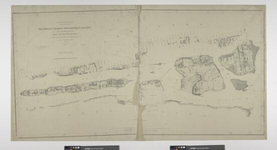
Blackwell's, Ward's and Randall's islands and adjacent shores of East and Harlem Rivers : from 51st St. New York to Lawrence's Pt. / U.S. Coast and Geodetic Survey, F.M. Thorn, superintendent ; surveyed by E. Hergesheimer, assistant, 1885.
from New York harbor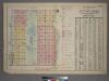
Outline and Index Map of Atlas of New York City, Borough of Manhattan. 59th St. to 110th Street. Street Index.
from Atlas of the city of New York, borough of Manhattan. From actual surveys and official plans / by George W. and Walter S. Bromley.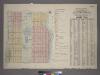
Outline & Index Map of Volume One, Atlas of New York City, Borough of Manhattan : 59th Street to 110th Street.
from Atlas of the city of New York, borough of Manhattan. From actual surveys and official plans / by George W. and Walter S. Bromley.
Outline and Index Map of Atlas of New York City.
from Atlas of the borough of Manhattan, city of New York.
New York N.
1 : 21120 Letts, Son & Co.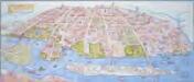
Map of the Astoria, Long Island City waterfront parks and environs: history, culture, ecology, parks / artwork, David Cain (map poster); George Colbert, Guenter Vollath (wayfinding map).
David Cain; George Colbert; Guenter Vollath,
M-T-10-100: Index Map of Central Park, Boro. of Manhattan.
from Topographical survey of portion of Central Park, Boro. of Manhattan ... / City of New York, Department of Parks, Topographical Division.
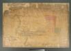
Hell Gate and its approaches / from a trigonometrical survey under the direction of F.R. Hassler and A.D. Bache, superintendents of the Survey of the Coast of the United States.
from New York harbor
64 Central Park Lots, New York City.
From Manhattan
Key
From Atlas 134. Vol. 2, 1915.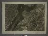
9A - N.Y. City (Aerial Set).
from Sectional aerial maps of the City of New York / [photographed and assembled under the direction of the chief engineer, July 1st, 1924].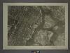
6C - N.Y. City (Aerial Set).
from Sectional aerial maps of the City of New York / [photographed and assembled under the direction of the chief engineer, July 1st, 1924].
Area District Map Section No. 9; Area district map / City of New York, Board of Estimate and Apportionment.
from Area district map / City of New York, Board of Estimate and Apportionment. New York (N.Y.). Board of Estimate and Apportionment,
Height District Map Section No. 9; Height district map / City of New York, Board of Estimate and Apportionment.
from Height district map / City of New York, Board of Estimate and Apportionment. New York (N.Y.). Board of Estimate and Apportionment,
Hell Gate & approaches.
1 : 5000 Hassler, F. R.
Data for population from census of 1910, Borough of Manhattan
From Manhattan
Sheet 16: [Bounded by E. Hundred & Twenty Fourth Street, 1st Avenue, E. Hundred & Twenty Second Street, Avenue A, E. Hundred & Twelfth Street, 1st Avenue, E. Ninety Second street and 5th Avenue.]
from Plan of New York City, from the Battery to Spuyten Duyvil Creek. Showing every lot and building thereon; old farm lines, strreet numbers at the corners of blocks, railroads, steamboat landings, bulkhead and pier lines, etc. Based on the surveys made by Messrs. Randall & Blackwell, and on the special survey by J. F. Harrison.
Sheet 14: [Bounded by E. Ninety Second Street, Avenue A, E. Nintieth Street, Avenue B, E. Seventy Second Street, Avenue A, [E. Fifty Ninth Street] and 5th Avenue.]
from Plan of New York City, from the Battery to Spuyten Duyvil Creek. Showing every lot and building thereon; old farm lines, strreet numbers at the corners of blocks, railroads, steamboat landings, bulkhead and pier lines, etc. Based on the surveys made by Messrs. Randall & Blackwell, and on the special survey by J. F. Harrison.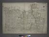
[Plate 2: Bounded by (East River) Vernon Avenue, Boulevard, Fulton Avenue, Mill Street, Orchard Street, Boulevard, Hoyt Avenue, Barclay Street, Woolsey Avenue, Rapelje Avenue and Freeman Avenue.]
from Atlas of the city of New York, borough of Queens, Long Island City, Newtown, Flushing, Jamaica, Far Rockaway, from actual surveys and official plans / by George W. and Walter S. Bromley.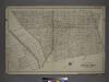
[Plate 4: Bounded by Rapelje Avenue, Woolsey Avenue, Flushing Avenue, Old Bowery Bay Road, Woodside Avenue, Middleburg Avenue, Celtic (Woodside) Avenue, Foster Avenue, Laurel Hill Avenue, Skillman Avenue, Harold Avenue and Jackson Avenue.]
from Atlas of the city of New York, borough of Queens, Long Island City, Newtown, Flushing, Jamaica, Far Rockaway, from actual surveys and official plans / by George W. and Walter S. Bromley.
Map of the Village of Astoria, queens Co., N.Y.
From Queens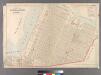
Part of Long Island City, Ward No. 5 (Steinway)
from Atlas of Queens Co., Long Island, New York / compiled from official records, private plans & actual surveys by and under the direction of Chester Wolverton.
Central Park
From Manhattan
Manhattan V. 7, Plate No. 55 [Map bounded by Columbus Ave., Cathedral Parkway, Central Park West, W. 108th St.]
From Atlas 121. Vol. 7, pt. 1, 1912.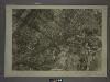
9C - N.Y. City (Aerial Set).
from Sectional aerial maps of the City of New York / [photographed and assembled under the direction of the chief engineer, July 1st, 1924].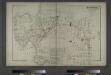
Astoria. Part of Long Island City, Town of Newtown, Queens Co. L.I.
from Atlas of Long Island, New York. From recent and actual surveys and records.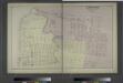
Ravenswood. Part of Long Island City. Queens Co. L.I.
from Atlas of Long Island, New York. From recent and actual surveys and records.
41. Central Park, Blackwells Island.
1 : 6000 G.W. Bromley & Co.; Geo. W. Bromley & E. Robinson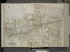
Queens, Vol. 2, Double Page Plate No. 8; Part of Long Island City Ward One (Part of Old Wards 4 and 5); [Map bounded by Hoyt Ave., Emily Terrace, Edward St., Barclay St., Vanalst Ave., Woolsey Ave., De Bevoise Ave. (Bradford St.), Lockwood St.,
from First and second wards: Long Island City and Newtown.