Maps of Manhattan Community Board 9

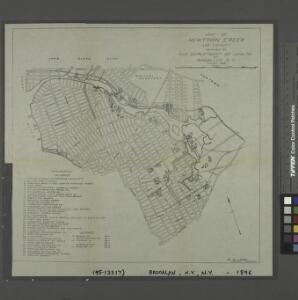
Map of Newtown Creek and vicinity / prepared by the Department of Health of Brooklyn, N.Y., January 1896 ; W.W. Locke, sanitary engineer.
from Brooklyn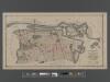
[Long Island City, Queens] Record of searches in relation to the legal status of avenues and streets in the 1st Ward of the Borough of Queens.
From Queens
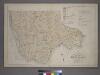
Map of Long Island City, Queens County, N. Y., showing farmlines, reduced from Commissioners new city map.
From Queens
Upper West Side, Yorkville, Lenox Hill, Welfare Island. (cont.)
From District 8
Key
From Atlas 141. Vol. 5, 1903.
Map and plan showing the street system in the 1st ward of the borough of Queens, formerly Long Island City.
From Queens
Maspeth, Sunnyside, Woodside. (cont.)
From District 2
Area District Map Section No. 13
from Area district map / City of New York, Board of Estimate and Apportionment.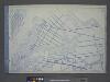
Use District Map Section No. 9
from Use district map / City of New York, Board of Estimate and Apportionment.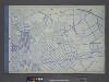
Use District Map Section No. 13
from Use district map / City of New York, Board of Estimate and Apportionment.
Area Zoning Map Section No. 13
From Area zoning map of the city of New York, compiled in the Dept. of City Planning, Division of Mapping and Zoning, May 27, 1953. Irving F. Ashworth, senior civil engineer.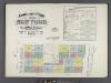
Insurance maps of the City of New York. Surveyed and published by Sanborn-Perris Map Co., Limited. 115 Broadway, 1892. Volume 6. / Key
From Atlas 117. Vol. 6, 1892.
Key
From Atlas 134. Vol. 2, 1915.
Map of Newtown Creek and vicinity [and factories nearby.]
From Brooklyn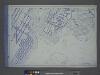
Use District Map Section No. 6
from Use district map / City of New York, Board of Estimate and Apportionment.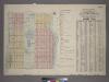
Outline & Index Map of Volume One, Atlas of New York City, Borough of Manhattan : 59th Street to 110th Street.
from Atlas of the city of New York, borough of Manhattan. From actual surveys and official plans / by George W. and Walter S. Bromley.
Outline and Index Map of Atlas of New York City.
from Atlas of the borough of Manhattan, city of New York.
Jackson Heights, North Corona, East Elmhurst. (cont.)
From District 3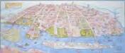
Map of the Astoria, Long Island City waterfront parks and environs: history, culture, ecology, parks / artwork, David Cain (map poster); George Colbert, Guenter Vollath (wayfinding map).
David Cain; George Colbert; Guenter Vollath,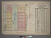
Outline and Index Map of Atlas of New York City, Borough of Manhattan. 59th St. to 110th Street. Street Index.
from Atlas of the city of New York, borough of Manhattan. From actual surveys and official plans / by George W. and Walter S. Bromley.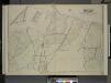
Queens, Vol.2, Double Page Plate No. 29; Part of Ward Two Newtown (East Williamsburgh, Melina and Nassau Heights); [Map bounded by Rotting Course Lane, Dry Harbor Road, Boundary between the Boroughs of Queens and Brooklyn, Newtown Creek, Bradle
from First and second wards: Long Island City and Newtown.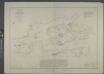
Hell Gate and its approaches / from a trigonometrical survey under the direction of F.R. Hassler and A.D. Bache, superintendents of the Survey of the Coast of the United States.
from New York harbor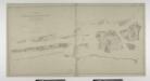
Blackwell's, Ward's and Randall's islands and adjacent shores of East and Harlem Rivers : from 51st St. New York to Lawrence's Pt. / U.S. Coast and Geodetic Survey, F.M. Thorn, superintendent ; surveyed by E. Hergesheimer, assistant, 1885.
from New York harbor
Map and plan showing the street system in the 1st ward of the borough of Queens, formerly Long Island City.
From Queens
Key
From Atlas 137a. Vol. 3, 1914.
Outline and Index Map, Sections 9 and 10, Borough of the Bronx.
from Atlas and owners names, borough of the Bronx, sections 9 & 10 : from actual surveys and official plans / by George W. and Walter S. Bromley.
Williamsburg, Greenpoint. (cont.)
From District 1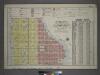
Outline and Index Map of Volume Four.
from Atlas of the city of New York, borough of Manhattan / from actual surveys and official plans by George W. and Walter S. Bromley.
Key Continued
From Atlas 148, Vol. 10, 1914.