Maps of Maryland

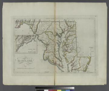
Maryland.
from Carey's general atlas, improved and enlarged : being a collection of maps of the world and quarters, their principal empires, kingdoms, &c.
Neueste Karte von Maryland und Delaware mit seinen Canaelen, Strassen und Entfernungen der Hauptpunkte
Grosser Hand-Atlas über alle Theile der Erde in 170 Karten Meyer, J. Verlag des Bibliographischen Instituts
A new map of Maryland and Delaware : with their canals, roads & distances / by H.S. Tanner ; E. Gillingham, sc.
from Parts
Nova Virginiae Tabula [Karte], in: Novus Atlas, das ist, Weltbeschreibung, Bd. 2, S. 325.
1 Karte aus Atlas Blaeu, Joan Blaeu, Willem Janszoon
Maryland und Delaware
1 : 500000 Sotzmann, D. F Bey Carl Ernst Bohn
Nova Virginiae Tabula [Karte], in: Le théâtre du monde, ou, Nouvel atlas contenant les chartes et descriptions de tous les païs de la terre, Bd. 2, S. 318.
1 Karte aus Atlas Blaeu, Willem Janszoon und Blaeu, Joan Blaeu, Willem Janszoon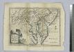
A map of Maryland with the Delaware counties and the southern part of New Jersey &c. / by T. Kitchin, geogr.
from Charts and maps Thomas Kitchin,
Delaware and Maryland. Baltimore.
1 : 958000 Gray, Ormando Willis
Map Of The Seat Of War.
1 : 633600 Monk, Jacob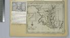
Maryland.
from Maryland
Delaware and Maryland.
1 : 960000 Colton, G.W.
The new war map of Virginia, Maryland & Pennsylvania
1 : 510000 Russel, B.B. (Benjamin B.)
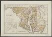
Maryland and Delaware.
1 : 1130000 Mitchell, Samuel Augustus
Maryland and Delaware.
1 : 1130000 Mitchell, Samuel Augustus
Shell Highway Map of Delaware - Maryland, Virginia, W. Virginia. (western portion).
1 : 950400 Shell Oil Company
Carte de la Virginie et du Maryland dressée sur la grande carte angloise de Mrs. Josué Fry et Pierre Jefferson, / par le Sr. Robert de Vaugondy, géographe; Groux.
from John H. Levine Collection Robert de Vaugondy; Mrs. Josué Fry et Pierre Jefferson,
Maryland and Delaware.
1 : 1190000 Tanner, Henry S.
Delaware and Maryland.
1 : 1000000 Colton, G.W.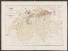
Nova Virginiae Tabula [Karte], in: Gerardi Mercatoris et I. Hondii Newer Atlas, oder, Grosses Weltbuch, Bd. 2, S. 392.
1 Karte aus Atlas Mercator, Gerhard und Hondius, Jodocus Jansson, Jan
NOVA VIRGINIÆ TABVLA
DGrijp Sculpt [Amsterdam : Joan Blaeu]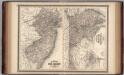
New Jersey, Delaware, and Maryland.
1 : 700000 Johnson, A.J.
Nova Virginae Tabula [Karte], in: Theatrum orbis terrarum, sive, Atlas novus, Bd. 2, S. 327.
1 Karte aus Atlas Blaeu, Joan Blaeu, Willem Janszoon
Map to illustrate the 1862 (Virginia) Campaign
Map to illustrate the 1862 (Virginia) Campaign. Map to illustrate the American Civil War of sixty years previously. This small map details the areas of Virginia around the capitals of Washington, D.C. and Richmond where a great amount of fighting took place in 1862 and indeed across the war period. Several places on the map, such as Fredericksburg, Petersburg and Manassas Junction/Bull Run witnessed heavy clashes during the conflict. The map also details railway routes in the region. War Office
A map of the most inhabited part of Virginia containing the whole province of Maryland with part of Pensilvania, New Jersey and North Carolina / drawn by Joshua Fry & Peter Jefferson in 1751.
From Parts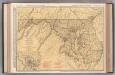
Maryland and Delaware.
1 : 602000 Rand McNally and Company
Delaware and Maryland.
1 : 1000000 Colton, G.W.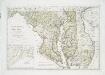
Maryland und Delaware / entworfen von D.F. Sotzmann ; W. Sander, sculp.
from Charts and maps
Maryland, Delaware.
1 : 1300000 Cram, George Franklin; Davis, Ellis Arthur