Maps of Kings County
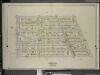
Brooklyn, Vol. 5, Double Page Plate No. 20; Part of Ward 29, Section 16; [Map bounded by E. 19th St., Dorchster Road; Including Argyle Road (E. 13th St.), Albemarle Road (Avenue A)]
from Ward 29 and part of 32.
Brooklyn V. 10, Plate No. 31 [Map bounded by 16th St., Church Ave., Ocean Ave., Albemarle Rd.]
From Atlas 92. Vol. 10, 1905.
Plate 5: [Bounded by Avenue A, Ocean Avenue, Avenue E, E. 13th Street, Avenue D, Coney Island Avenue, Avenue E, West Street and Church Lane.]
from Robinson's atlas of Kings County, New York : compiled from official records ... / under the direction of E. Robinson.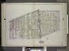
Brooklyn, Vol. 2, Double Page Plate No. 10; Part of Ward 29, Section 16; [Map bounded by Church Ave., Albemarle Road; Including E. 17th St., Cortelyou Road, West St.] / by and under the direction of Hugo Ullitz.
From Volume 2.
Part of Ward 29. Land Map Section, No. 16. Volume 2, Brooklyn Borough, New York City.
from Atlas of the Brooklyn borough of the City of New York : originally Kings Co.; complete in three volumes ... based upon official maps and plans ... / by and under the supervision of Hugo Ullitz, C.E.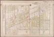
Plate 21: [Bounded by Ditmas Avenue, Coney Island Avenue, Ditmas Avenue, Ocean Avenue, Avenue I., Gravesend Avenue, 18th Avenue and West Street.]; Atlas of the borough of Brooklyn, city of New York: from actual surveys and official plans by George W. and Walter S. Bromley.
from Atlas of the borough of Brooklyn, city of New York : from actual surveys and official plans by George W. and Walter S. Bromley. G.W. Bromley & Co.,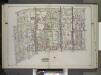
Brooklyn, Vol. 2, Double Page Plate No. 8; Part of Ward 29, Sections 15 & 16; [Map bounded by Church Ave., New York Ave., Clarendon Road; Including Dorchester Road, E. 17th St., E. 18th St.] / by and under the direction of Hugo Ullitz.
From Volume 2.
Part of Wards 29, 30, 31 & 32, Land Map Section, No. 16. Volume 2, Brooklyn Borough, New York City.
from Atlas of the Brooklyn borough of the City of New York : originally Kings Co.; complete in three volumes ... based upon official maps and plans ... / by and under the supervision of Hugo Ullitz, C.E.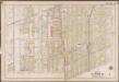
Plate 19: [Bounded by Albemarle Avenue, Ocean Parkway, Church Avenue, Coney Island Avenue, Avenue A., Ocean Avenue, Ditmas Avenue, Coney Island Avenue, Ditmas Avenue and West Street.]; Atlas of the borough of Brooklyn, city of New York: from actual surveys and official plans by George W. and Walter S. Bromley.
from Atlas of the borough of Brooklyn, city of New York : from actual surveys and official plans by George W. and Walter S. Bromley. G.W. Bromley & Co.,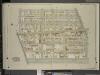
Brooklyn, Vol. 5, Double Page Plate No. 25; Part of Ward 29, Section 16; [Map bounded by Argyle Road, Cortelyou Road, Ocean Parkway; Including Church Lane, Albemarle Road]
from Ward 29 and part of 32.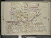
Brooklyn, Vol. 5, Double Page Plate No. 17; Part of Ward 29, Section 16; [Map bounded by Prospect St., E 26th St., Avenue D, Ditmas Ave. (Avenue E.); Including E. 19th St., Albemarle Road (Avenue A), Flatbush Ave., Tilden Ave.]
from Ward 29 and part of 32.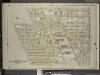
Brooklyn, Vol. 5, Double Page Plate No. 19; Part of Ward 29, 30, 31 & 32, Section 16; [Map bounded by E. 21st St., Kenmore Pl., Avenue G, Argyle Road; Including Dorchester Road, E. 19th St., Ditmas Ave.]
from Ward 29 and part of 32.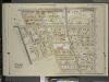
Brooklyn, Vol. 5, Double Page Plate No. 21; Part of Ward 29, Section 16; [Map bounded by Flatbush Ave., Albemarle Road (Avenue A), Rugby Road (E. 14th St.); Including Caton Ave. (Johnson Ave.), Parade Pl., Parkside Ave., Woodruff Ave.]
from Ward 29 and part of 32.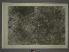
22B - N.Y. City (Aerial Set).
from Sectional aerial maps of the City of New York / [photographed and assembled under the direction of the chief engineer, July 1st, 1924].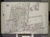
Brooklyn, Vol. 2, Double Page Plate No. 11; Part of Wards 22 & 29, Section 16; [Map bounded by Terace PL., Prospect Park South West, Coney Island Ave., Parkside Ave., Parade PL., E. 17th St.; Including E. 18th St., Albemarle Road, Church Ave., West A...
From Volume 2.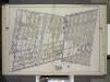
Brooklyn, Vol. 2, Double Page Plate No. 9; Part of Wards 29, 30 & 31 Section 16; [Map bounded by Cortelyou Road, E. 17th St., Avenue G; Including Foster Ave., Garvesend Ave., West St.] / by and under the direction of Hugo Ullitz.
From Volume 2.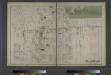
Flatbush. Town of Flatabush, Kings Co. L.I. - Prospect Park.
from Atlas of Long Island, New York. From recent and actual surveys and records.
Part of the Town of Flatbush, Kings Co., N.Y.
from Robinson's atlas of Kings County, New York : compiled from official records ... / under the direction of E. Robinson.
Part of Ward 29. Land Map Sections, Nos. 15, & 16. Volume 2, Brooklyn Borough, New York City.
from Atlas of the Brooklyn borough of the City of New York : originally Kings Co.; complete in three volumes ... based upon official maps and plans ... / by and under the supervision of Hugo Ullitz, C.E.
Part of Wards 22 & 29. Land Map Section, No. 16. Volume 2, Brooklyn Borough, New York City.
from Atlas of the Brooklyn borough of the City of New York : originally Kings Co.; complete in three volumes ... based upon official maps and plans ... / by and under the supervision of Hugo Ullitz, C.E.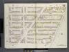
Brooklyn V. 2, Double Page Plate No. 51 [Map bounded by Clermont Ave., Atlantic Ave., S.Portland Ave., Lafayette Ave.]
From Atlas 66. Vol. 2, 1887.
Part of the Town of Flatbush, Kings Co., N.Y.
from Robinson's atlas of Kings County, New York : compiled from official records ... / under the direction of E. Robinson.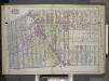
Brooklyn, Vol. 2, Double Page Plate No. 7; Part of Wards 29, 31 & 32, Sections 15 & 16; [Map bounded by Dorchester Road, Clarendon Road; Including E. 37th St., Glenwood Road, Avenue G, E. 17th St.] / by and under the direction of Hugo Ullitz.
From Volume 2.
Part of Wards 29 & 30, Land Map Sections, Nos. 16, 17 & 20, Volume 2, Brooklyn Borough, New York City.
from Atlas of the Brooklyn borough of the City of New York : originally Kings Co.; complete in three volumes ... based upon official maps and plans ... / by and under the supervision of Hugo Ullitz, C.E.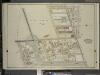
Brooklyn, Vol. 5, Double Page Plate No. 22; Part of Ward 29, Section 16; [Map bounded by Rugby Road (E. 14th St.), Albemarle Road (Avenue A), Church Ave., Church Lane, Ocean Parkway; Including Prospect Ave., Greenwood Ave., Parkside Ave., Cone
from Ward 29 and part of 32.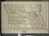
Brooklyn, Vol. 5, Double Page Plate No. 26; Part of Wards 29 & 30, Section 16; [Map bounded by Argyle Road, Avenue G, Foster Ave.; Including Ocean Parkway, Cortelyou Road]
from Ward 29 and part of 32.
Part of the Town of Flatbush, Kings Co., N.Y.
from Robinson's atlas of Kings County, New York : compiled from official records ... / under the direction of E. Robinson.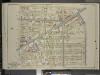
Brooklyn, Vol. 5, Double Page Plate No. 18; Part of Wards 29 & 32, Section 16; [Map bounded by E. 29th St., Avenue G, Kenmore Pl.; Including E. 21st St., Ditmas Ave., Avenue D]
from Ward 29 and part of 32.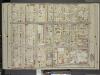
Brooklyn, Vol. 5, Double Page Plate No. 16; Part of Ward 29, Section 16; [Map bounded by Nostrand Ave., Tilden Ave. (Vernon Ave.); Including Flatbush Ave., Clarkson Ave.]
from Ward 29 and part of 32.
Area District Map Section No. 22; Area district map / City of New York, Board of Estimate and Apportionment.
from Area district map / City of New York, Board of Estimate and Apportionment. New York (N.Y.). Board of Estimate and Apportionment,
Use District Map Section No. 22; Use district map / City of New York, Board of Estimate and Apportionment.
from Use district map / City of New York, Board of Estimate and Apportionment. New York (N.Y.). Board of Estimate and Apportionment,
![Brooklyn, Vol. 5, Double Page Plate No. 20; Part of Ward 29, Section 16; [Map bounded by E. 19th St., Dorchster Road; Including Argyle Road (E. 13th St.), Albemarle Road (Avenue A)]](https://images-2.georeferencer.com/images/iiif/169090477122/full/,300/0/native.jpg)

