Maps of Kings County

Part of the Town of Flatbush, Kings Co., N.Y.
from Robinson's atlas of Kings County, New York : compiled from official records ... / under the direction of E. Robinson.
Part of Ward 29. Land Map Sections, Nos. 15, & 16. Volume 2, Brooklyn Borough, New York City.
from Atlas of the Brooklyn borough of the City of New York : originally Kings Co.; complete in three volumes ... based upon official maps and plans ... / by and under the supervision of Hugo Ullitz, C.E.
Brooklyn, Vol. 2, Double Page Plate No. 8; Part of Ward 29, Sections 15 & 16; [Map bounded by Church Ave., New York Ave., Clarendon Road; Including Dorchester Road, E. 17th St., E. 18th St.] / by and under the direction of Hugo Ullitz.
From Volume 2.
Brooklyn, Vol. 2, Double Page Plate No. 7; Part of Wards 29, 31 & 32, Sections 15 & 16; [Map bounded by Dorchester Road, Clarendon Road; Including E. 37th St., Glenwood Road, Avenue G, E. 17th St.] / by and under the direction of Hugo Ullitz.
From Volume 2.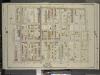
Brooklyn, Vol. 5, Double Page Plate No. 14; Part of Ward 29, Section 15 & 16; [Map bounded by Tilden Ave., Canarsie Ave., E. 37th St.; Including Avenue D, E. 26th St., Prospect St.]
from Ward 29 and part of 32.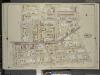
Brooklyn, Vol. 5, Double Page Plate No. 17; Part of Ward 29, Section 16; [Map bounded by Prospect St., E 26th St., Avenue D, Ditmas Ave. (Avenue E.); Including E. 19th St., Albemarle Road (Avenue A), Flatbush Ave., Tilden Ave.]
from Ward 29 and part of 32.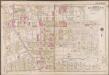
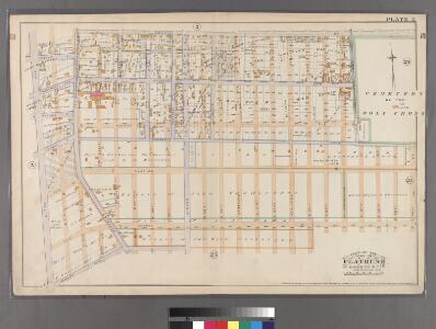
Plate 20: [Bounded by Regent Place, Tilden Avenue, (Holy Cross Cemetery) Canarsie Avenue, Canarsie Lane, E. 40th Street, Foster Avenue, E. 42nd Street, Farragut Road and Ocean Avenue.]; Atlas of the borough of Brooklyn, city of New York: from actual surveys and official plans by George W. and Walter S. Bromley.
from Atlas of the borough of Brooklyn, city of New York : from actual surveys and official plans by George W. and Walter S. Bromley. G.W. Bromley & Co.,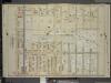
Brooklyn, Vol. 5, Double Page Plate No. 13; Part of Wards 29 & 32, Section 16; [Map bounded by Avenue D, E. 40th St.; Including Glenwood Road, E. 29th St.]
from Ward 29 and part of 32.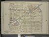
Brooklyn, Vol. 5, Double Page Plate No. 18; Part of Wards 29 & 32, Section 16; [Map bounded by E. 29th St., Avenue G, Kenmore Pl.; Including E. 21st St., Ditmas Ave., Avenue D]
from Ward 29 and part of 32.
Part of Wards 29, 30, 31 & 32, Land Map Section, No. 16. Volume 2, Brooklyn Borough, New York City.
from Atlas of the Brooklyn borough of the City of New York : originally Kings Co.; complete in three volumes ... based upon official maps and plans ... / by and under the supervision of Hugo Ullitz, C.E.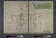
Flatbush. Town of Flatabush, Kings Co. L.I. - Prospect Park.
from Atlas of Long Island, New York. From recent and actual surveys and records.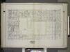
Brooklyn, Vol. 2, Double Page Plate No. 5; Part of Ward 29, Section 15; [Map bounded by Church Ave., E. 52nd St.; Including Clarendon Road, New York Ave.] / by and under the direction of Hugo Ullitz.
From Volume 2.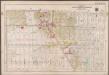
Plate 22: [Bounded by (Vanderveer Park) Farragut Road, Paerdegat Avenue, E. 42nd Street, Avenue J. and Ocean Avenue.]; Atlas of the borough of Brooklyn, city of New York: from actual surveys and official plans by George W. and Walter S. Bromley.
from Atlas of the borough of Brooklyn, city of New York : from actual surveys and official plans by George W. and Walter S. Bromley. G.W. Bromley & Co.,
Double Page Plate No. 5: [Bounded by Avenue D, East 53rd Street, Avenue E, East 52nd Street, Avenue F, East 51st Street, Paerdegat Avenue, Utica Avenue, Avenue G and Nostrand Avenue.]
from Atlas of the Brooklyn borough of the City of New York : originally Kings Co.; complete in three volumes ... based upon official maps and plans ... / by and under the supervision of Hugo Ullitz, C.E.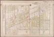
Plate 21: [Bounded by Ditmas Avenue, Coney Island Avenue, Ditmas Avenue, Ocean Avenue, Avenue I., Gravesend Avenue, 18th Avenue and West Street.]; Atlas of the borough of Brooklyn, city of New York: from actual surveys and official plans by George W. and Walter S. Bromley.
from Atlas of the borough of Brooklyn, city of New York : from actual surveys and official plans by George W. and Walter S. Bromley. G.W. Bromley & Co.,
Plate 2: [Bounded by Fenimore Street, Kingston Avenue, Winthrop Street, E. 39th Street, Linden Avenue, E. 40th Street, Grant Street, Flatbush Avenue, Church Lane, Ocean Avenue, Franklin Avenue and E. 21st Street.]
from Robinson's atlas of Kings County, New York : compiled from official records ... / under the direction of E. Robinson.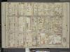
Brooklyn, Vol. 5, Double Page Plate No. 16; Part of Ward 29, Section 16; [Map bounded by Nostrand Ave., Tilden Ave. (Vernon Ave.); Including Flatbush Ave., Clarkson Ave.]
from Ward 29 and part of 32.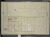
Brooklyn, Vol. 5, Double Page Plate No. 11; Part of Ward 29, Section 15; [Map bounded by Tilden Ave. (Vernon Ave.), E. 48th St.; Including Avenue D, E. 37th St., Canarsie Ave.]
from Ward 29 and part of 32.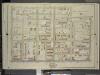
Brooklyn, Vol. 5, Double Page Plate No. 15; Part of Ward 29, Section 15; [Map bounded by E. 38th St., Canarsie Ave., Tilden Ave. (Vernon Ave.); Including Nostrand Ave., Clarkson Ave.]
from Ward 29 and part of 32.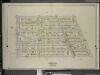
Brooklyn, Vol. 5, Double Page Plate No. 20; Part of Ward 29, Section 16; [Map bounded by E. 19th St., Dorchster Road; Including Argyle Road (E. 13th St.), Albemarle Road (Avenue A)]
from Ward 29 and part of 32.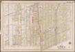
Plate 19: [Bounded by Albemarle Avenue, Ocean Parkway, Church Avenue, Coney Island Avenue, Avenue A., Ocean Avenue, Ditmas Avenue, Coney Island Avenue, Ditmas Avenue and West Street.]; Atlas of the borough of Brooklyn, city of New York: from actual surveys and official plans by George W. and Walter S. Bromley.
from Atlas of the borough of Brooklyn, city of New York : from actual surveys and official plans by George W. and Walter S. Bromley. G.W. Bromley & Co.,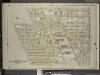
Brooklyn, Vol. 5, Double Page Plate No. 19; Part of Ward 29, 30, 31 & 32, Section 16; [Map bounded by E. 21st St., Kenmore Pl., Avenue G, Argyle Road; Including Dorchester Road, E. 19th St., Ditmas Ave.]
from Ward 29 and part of 32.
Brooklyn V. 10, Plate No. 31 [Map bounded by 16th St., Church Ave., Ocean Ave., Albemarle Rd.]
From Atlas 92. Vol. 10, 1905.
Brooklyn V. 15, Plate No. 1 [Map bounded by Flatbush Ave., Farragut Rd., Nostrand Ave., Glenwood Rd.]
From Atlas 101. Vol. 15, 1907.
23A - N.Y. City (Aerial Set).
from Sectional aerial maps of the City of New York / [photographed and assembled under the direction of the chief engineer, July 1st, 1924].
Plan of the city of Brooklyn, L.I. / by William Perris.
from Brooklyn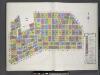
Key
From Atlas 92. Vol. 10, 1905.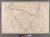
Plate 25: [Bounded by Avenue C, Ralph Avenue, Avenue L, Ocean Avenue, Avenue E, Avenue D and E. 31st Street.
from Robinson's atlas of Kings County, New York : compiled from official records ... / under the direction of E. Robinson.
Area District Map Section No. 23; Area district map / City of New York, Board of Estimate and Apportionment.
from Area district map / City of New York, Board of Estimate and Apportionment. New York (N.Y.). Board of Estimate and Apportionment,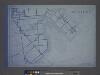
Use District Map Section No. 23; Use district map / City of New York, Board of Estimate and Apportionment.
from Use district map / City of New York, Board of Estimate and Apportionment. New York (N.Y.). Board of Estimate and Apportionment,