Maps of Kings County
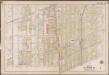
Plate 19: [Bounded by Albemarle Avenue, Ocean Parkway, Church Avenue, Coney Island Avenue, Avenue A., Ocean Avenue, Ditmas Avenue, Coney Island Avenue, Ditmas Avenue and West Street.]; Atlas of the borough of Brooklyn, city of New York: from actual surveys and official plans by George W. and Walter S. Bromley.
from Atlas of the borough of Brooklyn, city of New York : from actual surveys and official plans by George W. and Walter S. Bromley. G.W. Bromley & Co.,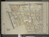
Brooklyn, Vol. 5, Double Page Plate No. 21; Part of Ward 29, Section 16; [Map bounded by Flatbush Ave., Albemarle Road (Avenue A), Rugby Road (E. 14th St.); Including Caton Ave. (Johnson Ave.), Parade Pl., Parkside Ave., Woodruff Ave.]
from Ward 29 and part of 32.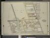
Brooklyn, Vol. 5, Double Page Plate No. 22; Part of Ward 29, Section 16; [Map bounded by Rugby Road (E. 14th St.), Albemarle Road (Avenue A), Church Ave., Church Lane, Ocean Parkway; Including Prospect Ave., Greenwood Ave., Parkside Ave., Cone
from Ward 29 and part of 32.
Brooklyn V. 10, Plate No. 31 [Map bounded by 16th St., Church Ave., Ocean Ave., Albemarle Rd.]
From Atlas 92. Vol. 10, 1905.
Part of the Town of Flatbush, Kings Co., N.Y.
from Robinson's atlas of Kings County, New York : compiled from official records ... / under the direction of E. Robinson.
Part of Wards 22 & 29. Land Map Section, No. 16. Volume 2, Brooklyn Borough, New York City.
from Atlas of the Brooklyn borough of the City of New York : originally Kings Co.; complete in three volumes ... based upon official maps and plans ... / by and under the supervision of Hugo Ullitz, C.E.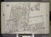
Brooklyn, Vol. 2, Double Page Plate No. 11; Part of Wards 22 & 29, Section 16; [Map bounded by Terace PL., Prospect Park South West, Coney Island Ave., Parkside Ave., Parade PL., E. 17th St.; Including E. 18th St., Albemarle Road, Church Ave., West A...
From Volume 2.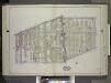
Brooklyn, Vol. 2, Double Page Plate No. 10; Part of Ward 29, Section 16; [Map bounded by Church Ave., Albemarle Road; Including E. 17th St., Cortelyou Road, West St.] / by and under the direction of Hugo Ullitz.
From Volume 2.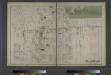
Flatbush. Town of Flatabush, Kings Co. L.I. - Prospect Park.
from Atlas of Long Island, New York. From recent and actual surveys and records.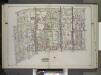
Brooklyn, Vol. 2, Double Page Plate No. 8; Part of Ward 29, Sections 15 & 16; [Map bounded by Church Ave., New York Ave., Clarendon Road; Including Dorchester Road, E. 17th St., E. 18th St.] / by and under the direction of Hugo Ullitz.
From Volume 2.
Plate 5: [Bounded by Avenue A, Ocean Avenue, Avenue E, E. 13th Street, Avenue D, Coney Island Avenue, Avenue E, West Street and Church Lane.]
from Robinson's atlas of Kings County, New York : compiled from official records ... / under the direction of E. Robinson.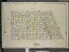
Brooklyn, Vol. 5, Double Page Plate No. 20; Part of Ward 29, Section 16; [Map bounded by E. 19th St., Dorchster Road; Including Argyle Road (E. 13th St.), Albemarle Road (Avenue A)]
from Ward 29 and part of 32.
Part of Ward 29. Land Map Sections, Nos. 15, & 16. Volume 2, Brooklyn Borough, New York City.
from Atlas of the Brooklyn borough of the City of New York : originally Kings Co.; complete in three volumes ... based upon official maps and plans ... / by and under the supervision of Hugo Ullitz, C.E.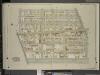
Brooklyn, Vol. 5, Double Page Plate No. 25; Part of Ward 29, Section 16; [Map bounded by Argyle Road, Cortelyou Road, Ocean Parkway; Including Church Lane, Albemarle Road]
from Ward 29 and part of 32.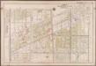
Plate 21: [Bounded by Ditmas Avenue, Coney Island Avenue, Ditmas Avenue, Ocean Avenue, Avenue I., Gravesend Avenue, 18th Avenue and West Street.]; Atlas of the borough of Brooklyn, city of New York: from actual surveys and official plans by George W. and Walter S. Bromley.
from Atlas of the borough of Brooklyn, city of New York : from actual surveys and official plans by George W. and Walter S. Bromley. G.W. Bromley & Co.,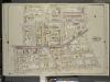
Brooklyn, Vol. 5, Double Page Plate No. 17; Part of Ward 29, Section 16; [Map bounded by Prospect St., E 26th St., Avenue D, Ditmas Ave. (Avenue E.); Including E. 19th St., Albemarle Road (Avenue A), Flatbush Ave., Tilden Ave.]
from Ward 29 and part of 32.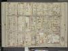
Brooklyn, Vol. 5, Double Page Plate No. 16; Part of Ward 29, Section 16; [Map bounded by Nostrand Ave., Tilden Ave. (Vernon Ave.); Including Flatbush Ave., Clarkson Ave.]
from Ward 29 and part of 32.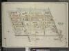
Brooklyn, Vol. 5, Double Page Plate No. 24; Part of Ward 29, Section 16; [Map bounded by Ocean Parkway, Church Lane, West St., Fort Hamilton Ave.; Including Gravesend Ave., Greenwood Ave., Prospect Ave.]
from Ward 29 and part of 32.
Brooklyn, Section 10; [Including Ward 22]
from Farm line map of the city of Brooklyn, from official records and surveys; comp. and drawn by Henry Fulton.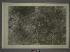
22B - N.Y. City (Aerial Set).
from Sectional aerial maps of the City of New York / [photographed and assembled under the direction of the chief engineer, July 1st, 1924].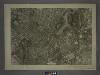
16D - N.Y. City (Aerial Set).
from Sectional aerial maps of the City of New York / [photographed and assembled under the direction of the chief engineer, July 1st, 1924].
[Sheet 2: Map encompassing Prospect Park, Windsor Terrace, Park Slope, Carroll Gardens, Gowanus Canal, Fort Greene, Clinton Hill and Prospect Heights.]
from Map of the city of Brooklyn : being the former cities of Brooklyn & Williamsburgh and the town of Bushwick, as consolidated January 1st, 1855 by an act of the legislature of the State of New York ... showing also a part of the City of New York.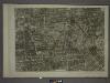
17C - N.Y. City (Aerial Set).
from Sectional aerial maps of the City of New York / [photographed and assembled under the direction of the chief engineer, July 1st, 1924].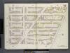
Brooklyn V. 2, Double Page Plate No. 51 [Map bounded by Clermont Ave., Atlantic Ave., S.Portland Ave., Lafayette Ave.]
From Atlas 66. Vol. 2, 1887.
Sec. 10. Brooklyn map.
1 : 6000 Fulton, Henry; J.B. Beers & Co.
Part of Ward 29. Land Map Section, No. 16. Volume 2, Brooklyn Borough, New York City.
from Atlas of the Brooklyn borough of the City of New York : originally Kings Co.; complete in three volumes ... based upon official maps and plans ... / by and under the supervision of Hugo Ullitz, C.E.
Plate 2: [Bounded by Fenimore Street, Kingston Avenue, Winthrop Street, E. 39th Street, Linden Avenue, E. 40th Street, Grant Street, Flatbush Avenue, Church Lane, Ocean Avenue, Franklin Avenue and E. 21st Street.]
from Robinson's atlas of Kings County, New York : compiled from official records ... / under the direction of E. Robinson.
Part of the Town of Flatbush, Kings Co., N.Y.
from Robinson's atlas of Kings County, New York : compiled from official records ... / under the direction of E. Robinson.
Part of Ward 29. Land Map Sections, Nos. 4, 5, & 16. Volume 2, Brooklyn Borough, New York City.
from Atlas of the Brooklyn borough of the City of New York : originally Kings Co.; complete in three volumes ... based upon official maps and plans ... / by and under the supervision of Hugo Ullitz, C.E.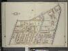
![Plate 19: [Bounded by Albemarle Avenue, Ocean Parkway, Church Avenue, Coney Island Avenue, Avenue A., Ocean Avenue, Ditmas Avenue, Coney Island Avenue, Ditmas Avenue and West Street.]; Atlas of the borough of Brooklyn, city of New York: from actual surveys and official plans by George W. and Walter S. Bromley.](https://images-2.georeferencer.com/images/iiif/705750280890/full/,300/0/native.jpg)

