Maps of Kings County
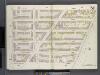
Brooklyn V. 2, Double Page Plate No. 51 [Map bounded by Clermont Ave., Atlantic Ave., S.Portland Ave., Lafayette Ave.]
From Atlas 66. Vol. 2, 1887.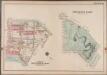
Plate 36: Prospect Park [Bounded by (Institute Park) Flatbush Avenue, Ocean Avenue, Caton Avenue, Coney Island Avenue, Seeley Avenue, Prospect Avenue, Terrace Place, (Greenwood Cemetery) Gavesend Avenue, 20th Street and Prospect Park West.]; Atlas of the borough of Brooklyn, city of New York: from actual surveys and official plans by George W. and Walter S. Bromley.
from Atlas of the borough of Brooklyn, city of New York : from actual surveys and official plans by George W. and Walter S. Bromley. G.W. Bromley & Co.,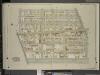
Brooklyn, Vol. 5, Double Page Plate No. 25; Part of Ward 29, Section 16; [Map bounded by Argyle Road, Cortelyou Road, Ocean Parkway; Including Church Lane, Albemarle Road]
from Ward 29 and part of 32.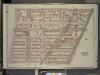
Brooklyn, Vol. 2, Double Page Plate No. 3; Part of Ward 20, Section 7; [Map bounded by Washington Ave., Atlantic Ave.; Including South Oxford St., De Kalb Ave.]
from Wards 7, 11, 20, 21, 23, 24 & 25.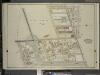
Brooklyn, Vol. 5, Double Page Plate No. 22; Part of Ward 29, Section 16; [Map bounded by Rugby Road (E. 14th St.), Albemarle Road (Avenue A), Church Ave., Church Lane, Ocean Parkway; Including Prospect Ave., Greenwood Ave., Parkside Ave., Cone
from Ward 29 and part of 32.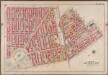
Plate 6: [Bounded by Fifth Avenue, Atlantic Avenue, S. Portland Avenue, Hanson Place, Greene Avenue, Clermont Avenue, Lafayette Avenue, Washington Avenue, Underhill Avenue, Eastern Parkway, Prospect Park West and President Street.]; Atlas of the borough of Brooklyn, city of New York: from actual surveys and official plans by George W. and Walter S. Bromley.
from Atlas of the borough of Brooklyn, city of New York : from actual surveys and official plans by George W. and Walter S. Bromley. G.W. Bromley & Co.,
[Plate 22: Map bounded by Myrtle Avenue, Clinton Street, Lafayette Avenue, Cumberland Street]
from Maps of the city of Brooklyn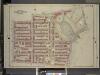
Brooklyn, Vol. 1, Double Page Plate No. 20; Part of Wards 9 & 22, Section 4; [Map bounded by Sterling PL., Underhil Ave., Eastern Parkway, Prospect Park West; Including Garfield PL., 6th Ave., St. Johns PL., 7th Ave., Flatbush Ave.]
from Wards 1, 2, 3, 4, 5, 6, 8, 9, 10, 12 & 22.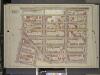
Brooklyn, Vol. 1, Double Page Plate No. 16; Part of Ward 9, Section 4; [Map bounded by Atlantic Ave., Underhill Ave., Sterling PL., St. John PL.; Including Flatbush Ave., 7th Ave, 6th Ave.]
from Wards 1, 2, 3, 4, 5, 6, 8, 9, 10, 12 & 22.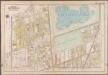
Plate 16: [Bounded by Terrace Place, 11th Avenue, Prospect Avenue, Seeley Street, (Prospect Park) Coney Island Avenue, Parkside Avenue, Ocean Avenue, Albemarle Road, Church Avenue, West Street, Fort Hamilton Avenue and (Greenwood Cemetery) Gravesend Avenue.]; Atlas of the borough of Brooklyn, city of New York: from actual surveys and official plans by George W. and Walter S. Bromley.
from Atlas of the borough of Brooklyn, city of New York : from actual surveys and official plans by George W. and Walter S. Bromley. G.W. Bromley & Co.,
Brooklyn, Vol. 2, Double Page Plate No. 4; Part of Wards 20 & 11, Section 7; [Map bounded by Waverly Ave., De Kalb Ave.; Including North Elliott PL., Flushing Ave.]
from Wards 7, 11, 20, 21, 23, 24 & 25.
Brooklyn, V. 6, Double Page Plate No. 149 [Map bounded by Prospect Place, Carlton Ave., Atlantic Ave., Underhill Ave.]
From Atlas 80. Vol. 6, 1888.
Brooklyn, V. 7, Double Page Plate No. B [Map bounded by Fenimore St., Ocean Ave., Malbone Ave.]
From Atlas 83. Vol. 7, 1888.
[Plate 21: Map bounded by Flushing Avenue, Clinton Avenue, Myrtle Avenue, Cumberland Street]
from Maps of the city of Brooklyn
[Plate 23: Map bounded by Lafayette Avenue, Cumberland Street, Atlantic Avenue, 4th Avenue, Raymond Street]
from Maps of the city of Brooklyn
[Plate 24: Map bounded by Myrtle Avenue, Cumberland Street, Lafayette Avenue, Raymond Street]
from Maps of the city of Brooklyn
Brooklyn, Section 10; [Including Ward 22]
from Farm line map of the city of Brooklyn, from official records and surveys; comp. and drawn by Henry Fulton.
Sec. 10. Brooklyn map.
1 : 6000 Fulton, Henry; J.B. Beers & Co.
[Plate 6: Bounded by Washington Avenue, Underhill Avenue, Parkway, Ninth Avenue, President Street, Fifth Avenue, Atlantic Avenue, Portland Avenue, Hanson Place, Greene Avenue, Clermont Avenue and Lafayette Avenue.]
from Atlas of the city of Brooklyn, New York.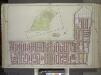
Brooklyn, Vol. 1, Double Page Plate No. 13; Part of Ward 22, Section 4; [Map bounded by Prospect Park West, 15th St., Coney Island Rd., 11th Ave.; Including Prospect Ave., 7th Ave., Carroll St]; Sub Plan [Map bounded by Ocean Ave., Gaton Ave., Coney I...
From Volume 1
Part of Wards 9, 22 & 29. Land Map Sections, No. 4 & 6, Volume 1, Brooklyn Borough, New York City.
from Atlas of the Brooklyn borough of the City of New York : originally Kings Co.; complete in three volumes ... based upon official maps and plans ... / by and under the supervision of Hugo Ullitz, C.E.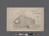
University Park, Brooklyn, N. Y., general improvement plan.
From Brooklyn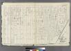
Plate 12: Part of Ward 22. City of Brooklyn.
from Atlas of the entire city of Brooklyn, complete in one volume. From actual surveys and official records by G. W. Bromley & Co.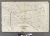
Plate 9: Part of Wards 3, 9, 10, 11, 20 & 22. City of Brooklyn.
from Atlas of the entire city of Brooklyn, complete in one volume. From actual surveys and official records by G. W. Bromley & Co.
Brooklyn, Vol. 2, Double Page Plate No. 11; Part of Wards 22 & 29, Section 16; [Map bounded by Terace PL., Prospect Park South West, Coney Island Ave., Parkside Ave., Parade PL., E. 17th St.; Including E. 18th St., Albemarle Road, Church Ave., West A...
From Volume 2.
Part of Wards 9, 22 . Land Map Section, No. 4 , Volume 1, Brooklyn Borough, New York City.
from Atlas of the Brooklyn borough of the City of New York : originally Kings Co.; complete in three volumes ... based upon official maps and plans ... / by and under the supervision of Hugo Ullitz, C.E.
Brooklyn, Vol. 1, Double Page Plate No. 15; Part of Wards 9, 22 & 29, Section 4; [Map bounded by Atlantic Ave., Franklin Ave., Carroll St., Institute Park, Flatbush Ave., Plaza, Prospect Park Ave.; Including Carroll St., 7th Ave., Flatbush Ave., Carlt...
From Volume 1
Part of Wards 9, 22 . Land Map Section, No. 4 , Volume 1, Brooklyn Borough, New York City.
from Atlas of the Brooklyn borough of the City of New York : originally Kings Co.; complete in three volumes ... based upon official maps and plans ... / by and under the supervision of Hugo Ullitz, C.E.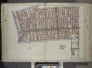
Brooklyn, Vol. 1, Double Page Plate No. 14; Part of Wards 9 & 22, Section 4; [Map bounded by 7th Ave., 3rd St., Gowanus Canal, Lateral Canal; Including 1st St., 4th Ave., Atlantic Ave., Carlton Ave., Flatbush Ave.] / by and under the direction of Hugo...
From Volume 1
![Brooklyn V. 2, Double Page Plate No. 51 [Map bounded by Clermont Ave., Atlantic Ave., S.Portland Ave., Lafayette Ave.]](https://images-2.georeferencer.com/images/iiif/424291332984/full/,300/0/native.jpg)

