Maps of Kings County
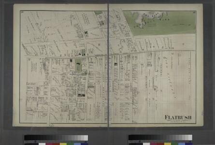
Flatbush. Town of Flatabush, Kings Co. L.I. - Prospect Park.
from Atlas of Long Island, New York. From recent and actual surveys and records.
Part of Ward 29. Land Map Sections, Nos. 4, 5, & 16. Volume 2, Brooklyn Borough, New York City.
from Atlas of the Brooklyn borough of the City of New York : originally Kings Co.; complete in three volumes ... based upon official maps and plans ... / by and under the supervision of Hugo Ullitz, C.E.
Plate 2: [Bounded by Fenimore Street, Kingston Avenue, Winthrop Street, E. 39th Street, Linden Avenue, E. 40th Street, Grant Street, Flatbush Avenue, Church Lane, Ocean Avenue, Franklin Avenue and E. 21st Street.]
from Robinson's atlas of Kings County, New York : compiled from official records ... / under the direction of E. Robinson.
Brooklyn, Vol. 2, Double Page Plate No. 8; Part of Ward 29, Sections 15 & 16; [Map bounded by Church Ave., New York Ave., Clarendon Road; Including Dorchester Road, E. 17th St., E. 18th St.] / by and under the direction of Hugo Ullitz.
From Volume 2.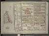
Brooklyn, Vol. 5, Double Page Plate No. 1; Part of Wards 29, Section 16; [Map bounded by Lincoln Road, Rogers Ave., Clarkson Ave.; Including Woodruff Ave., Ocean Ave.]; Sub Plan; [Map bounded by Flatbush Ave., Lincoln Road, Ocean Ave.; Including
from Ward 29 and part of 32.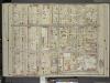
Brooklyn, Vol. 5, Double Page Plate No. 16; Part of Ward 29, Section 16; [Map bounded by Nostrand Ave., Tilden Ave. (Vernon Ave.); Including Flatbush Ave., Clarkson Ave.]
from Ward 29 and part of 32.
Part of Ward 29. Land Map Sections, Nos. 15, & 16. Volume 2, Brooklyn Borough, New York City.
from Atlas of the Brooklyn borough of the City of New York : originally Kings Co.; complete in three volumes ... based upon official maps and plans ... / by and under the supervision of Hugo Ullitz, C.E.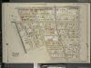
Brooklyn, Vol. 5, Double Page Plate No. 21; Part of Ward 29, Section 16; [Map bounded by Flatbush Ave., Albemarle Road (Avenue A), Rugby Road (E. 14th St.); Including Caton Ave. (Johnson Ave.), Parade Pl., Parkside Ave., Woodruff Ave.]
from Ward 29 and part of 32.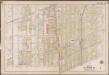
Plate 19: [Bounded by Albemarle Avenue, Ocean Parkway, Church Avenue, Coney Island Avenue, Avenue A., Ocean Avenue, Ditmas Avenue, Coney Island Avenue, Ditmas Avenue and West Street.]; Atlas of the borough of Brooklyn, city of New York: from actual surveys and official plans by George W. and Walter S. Bromley.
from Atlas of the borough of Brooklyn, city of New York : from actual surveys and official plans by George W. and Walter S. Bromley. G.W. Bromley & Co.,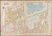
Plate 16: [Bounded by Terrace Place, 11th Avenue, Prospect Avenue, Seeley Street, (Prospect Park) Coney Island Avenue, Parkside Avenue, Ocean Avenue, Albemarle Road, Church Avenue, West Street, Fort Hamilton Avenue and (Greenwood Cemetery) Gravesend Avenue.]; Atlas of the borough of Brooklyn, city of New York: from actual surveys and official plans by George W. and Walter S. Bromley.
from Atlas of the borough of Brooklyn, city of New York : from actual surveys and official plans by George W. and Walter S. Bromley. G.W. Bromley & Co.,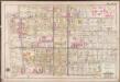
Plate 18: [Bounded by Winthrop Street, (Kings County Buildings) E. 39th Street, Lenox Road, E. 40th Street, Snyder Avenue, (Cemetery of the Holy Cross) Canarsie Avenue, Tilden Avenue, Regent Place, Ocean Avenue, Parkside Avenue & Flatbush Avenue.]; Atlas of the borough of Brooklyn, city of New York: from actual surveys and official plans by George W. and Walter S. Bromley.
from Atlas of the borough of Brooklyn, city of New York : from actual surveys and official plans by George W. and Walter S. Bromley. G.W. Bromley & Co.,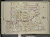
Brooklyn, Vol. 5, Double Page Plate No. 17; Part of Ward 29, Section 16; [Map bounded by Prospect St., E 26th St., Avenue D, Ditmas Ave. (Avenue E.); Including E. 19th St., Albemarle Road (Avenue A), Flatbush Ave., Tilden Ave.]
from Ward 29 and part of 32.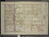
Brooklyn, Vol. 5, Double Page Plate No. 2; Part of Wards 29, Section 15 & 16; [Map bounded by Lincoln Road, East New York Ave., Kingston Ave.; Including E. 39th St., Clarkson Ave., Rogers Ave.]
from Ward 29 and part of 32.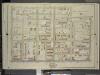
Brooklyn, Vol. 5, Double Page Plate No. 15; Part of Ward 29, Section 15; [Map bounded by E. 38th St., Canarsie Ave., Tilden Ave. (Vernon Ave.); Including Nostrand Ave., Clarkson Ave.]
from Ward 29 and part of 32.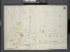
Brooklyn, V. 7, Double Page Plate No. B [Map bounded by Fenimore St., Ocean Ave., Malbone Ave.]
From Atlas 83. Vol. 7, 1888.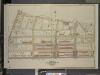
Brooklyn, Vol. 2, Double Page Plate No. 26; Part of Wards 24 & 29, Section 5; [Map bounded by Montgomery St., New York Ave., Lincoln Road; Including Lefferts St., Sterling St., Malbone St., Franklin Ave.]
from Wards 7, 11, 20, 21, 23, 24 & 25.
Brooklyn V. 10, Plate No. 31 [Map bounded by 16th St., Church Ave., Ocean Ave., Albemarle Rd.]
From Atlas 92. Vol. 10, 1905.
Plate 1: [Bounded by Montgomery Street, New York Avenue, Malbone Street, Kingston Avenue, Fenimore Street, Ocean Avenue and Flatbush Avenue.]
from Robinson's atlas of Kings County, New York : compiled from official records ... / under the direction of E. Robinson.
Sec. 10. Brooklyn map.
1 : 6000 Fulton, Henry; J.B. Beers & Co.
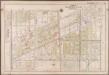
Part of the Town of Flatbush, Kings Co., N.Y.
from Robinson's atlas of Kings County, New York : compiled from official records ... / under the direction of E. Robinson.
Part of the Town of Flatbush, Kings Co., N.Y.
from Robinson's atlas of Kings County, New York : compiled from official records ... / under the direction of E. Robinson.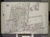
Brooklyn, Vol. 2, Double Page Plate No. 11; Part of Wards 22 & 29, Section 16; [Map bounded by Terace PL., Prospect Park South West, Coney Island Ave., Parkside Ave., Parade PL., E. 17th St.; Including E. 18th St., Albemarle Road, Church Ave., West A...
From Volume 2.
Part of Wards 22 & 29. Land Map Section, No. 16. Volume 2, Brooklyn Borough, New York City.
from Atlas of the Brooklyn borough of the City of New York : originally Kings Co.; complete in three volumes ... based upon official maps and plans ... / by and under the supervision of Hugo Ullitz, C.E.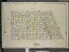
Brooklyn, Vol. 5, Double Page Plate No. 20; Part of Ward 29, Section 16; [Map bounded by E. 19th St., Dorchster Road; Including Argyle Road (E. 13th St.), Albemarle Road (Avenue A)]
from Ward 29 and part of 32.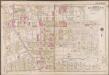
Plate 20: [Bounded by Regent Place, Tilden Avenue, (Holy Cross Cemetery) Canarsie Avenue, Canarsie Lane, E. 40th Street, Foster Avenue, E. 42nd Street, Farragut Road and Ocean Avenue.]; Atlas of the borough of Brooklyn, city of New York: from actual surveys and official plans by George W. and Walter S. Bromley.
from Atlas of the borough of Brooklyn, city of New York : from actual surveys and official plans by George W. and Walter S. Bromley. G.W. Bromley & Co.,
Part of Wards 24 & 29. Land Map Section, No. 5, Volume 1, Brooklyn Borough, New York City.
from Atlas of the Brooklyn borough of the City of New York : originally Kings Co.; complete in three volumes ... based upon official maps and plans ... / by and under the supervision of Hugo Ullitz, C.E.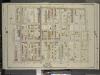
Brooklyn, Vol. 5, Double Page Plate No. 14; Part of Ward 29, Section 15 & 16; [Map bounded by Tilden Ave., Canarsie Ave., E. 37th St.; Including Avenue D, E. 26th St., Prospect St.]
from Ward 29 and part of 32.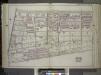
Brooklyn, Vol. 1, Double Page Plate No. 16; Part of Wards 24 & 29, Section 5; [Map bounded by Eastern Parkway, Albany Ave., East New York Ave.; Including Lincoln Road, Washington Ave., Franklin Ave.] / by and under the direction of Hugo Ullitz.
From Volume 1
Part of Ward 29. Land Map Sections, No. 5 & 15, Volume 2, Brooklyn Borough, New York City.
from Atlas of the Brooklyn borough of the City of New York : originally Kings Co.; complete in three volumes ... based upon official maps and plans ... / by and under the supervision of Hugo Ullitz, C.E.