Maps of Bronx County

Area District Map Section No. 7
from Area district map / City of New York, Board of Estimate and Apportionment.
Key Continued
From Atlas 141. Vol. 5, 1903.
Use District Map Section No. 7; Use district map / City of New York, Board of Estimate and Apportionment.
from Use district map / City of New York, Board of Estimate and Apportionment. New York (N.Y.). Board of Estimate and Apportionment,
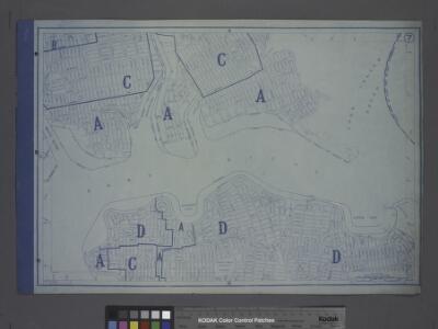
Height District Map Section No. 7; Height district map / City of New York, Board of Estimate and Apportionment.
from Height district map / City of New York, Board of Estimate and Apportionment. New York (N.Y.). Board of Estimate and Apportionment,
Planning Grid of the Office of the Topographical Bureau of Bronx.
from Topographical survey and new street system of the borough of the Bronx, easterly of the Bronx River
7C - N.Y. City (Aerial Set).
from Sectional aerial maps of the City of New York / [photographed and assembled under the direction of the chief engineer, July 1st, 1924].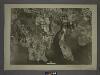
7A - N.Y. City (Aerial Set).
from Sectional aerial maps of the City of New York / [photographed and assembled under the direction of the chief engineer, July 1st, 1924].
7B - N.Y. City (Aerial Set).
from Sectional aerial maps of the City of New York / [photographed and assembled under the direction of the chief engineer, July 1st, 1924].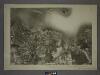
7D - N.Y. City (Aerial Set).
from Sectional aerial maps of the City of New York / [photographed and assembled under the direction of the chief engineer, July 1st, 1924].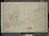
Queens, Vol. 3, Double Page Plate No. 4; Part of ward Three College Point. [Map bounded by 11th Ave., 10th Ave., 7th Ave., 6th Ave., Linden Ave., 5th Ave., Simths Lane, 4th Ave., Lawrence Ave., 3rd Ave., Nostrand Lane, Old Flushing Rd., Whitestone
from Third ward: Flushing.
West Chester, Schuylerville.
1 : 14400 Bromley, George Washington; Bromley, Walter Scott; G.W. Bromley & Co.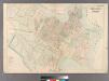
College Point.
from Atlas of Queens Co., Long Island, New York / compiled from official records, private plans & actual surveys by and under the direction of Chester Wolverton.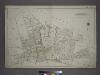
Part of the Borough of Queens, Flushing, Ward 3.
from Atlas of the city of New York, borough of Queens, Long Island City, Newtown, Flushing, Jamaica, Far Rockaway, from actual surveys and official plans / by George W. and Walter S. Bromley.
[Plate 23: Bounded by (East River) Avenue G, North Boulevard, N. 20th Street, Avenue C, Boulevard Drive, South Point, Circle Boulevard Drive, Malba Drive, 18th Street, Third Avenue, N. 22nd Street, Fourth Avenue, 5th Street, Third Avenue, First Street, F
from Atlas of the city of New York, borough of Queens, Long Island City, Newtown, Flushing, Jamaica, Far Rockaway, from actual surveys and official plans / by George W. and Walter S. Bromley.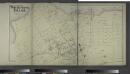
Part of Whitestone Village. Town of Flushing, Queens Co. L.I. [Covers from 3rd Avenue to 17th Avenue, and Boulevard to 17th Street.]
from Atlas of Long Island, New York. From recent and actual surveys and records.
Planning Grid of the Office of the Topographical Bureau of Bronx.
from Topographical survey sheets of the borough of the Bronx easterly of the Bronx River.
Queens, Vol. 3, Double Page Plate No. 13; Part of Ward Three Whitestone; [Map bounded by 14th Ave., Bayside Ave., 12th Ave., 8th Ave., Irving PL., 11th Ave., Whitestone Ave., 2nd PL., Boulevard, Post PL., Schuyler Ave., 7th Ave., Croton Ave
from Third ward: Flushing.
Part of College Point, Town of Flushing, Queens Co.
from Atlas of Long Island, New York. From recent and actual surveys and records.
Planning Grid of the Office of the Topographical Bureau of Bronx.
from Topographical survey sheets of the borough of the Bronx easterly of the Bronx River.
Sheet 32: Grid #24000E - 28000E, #5000S - 9000S. [Includes from 1st Street to 10th Street, from Westchester Creek to Avenue B, Union Port, (St. Raymond's Cemetery) and Westchester Avenue.]
from Topographical survey sheets of the borough of the Bronx easterly of the Bronx River.
Planning Grid of the Office of the Topographical Bureau of Bronx.
from Topographical survey sheets of the borough of the Bronx easterly of the Bronx River.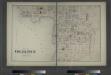
Part of College Point. Town of Flushing, Queens Co.
from Atlas of Long Island, New York. From recent and actual surveys and records.
[Plate 26: Willets Point Road (Little Bay), Bell Avenue (Little Neck Bay), Bayside Road and Weststone Road. ]
from Atlas of the city of New York, borough of Queens, Long Island City, Newtown, Flushing, Jamaica, Far Rockaway, from actual surveys and official plans / by George W. and Walter S. Bromley.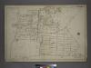
Part of the Borough of Queens, Flushing, Ward 3.
from Atlas of the city of New York, borough of Queens, Long Island City, Newtown, Flushing, Jamaica, Far Rockaway, from actual surveys and official plans / by George W. and Walter S. Bromley.
Bronx, V. A, Plate No. 28 [Map bounded by Westchester Creek, Turnbull Ave., Havemeyer Ave., Ludlow Ave.]
From Vol. A
Planning Grid of the Office of the Topographical Bureau of Bronx.
from Topographical survey sheets of the borough of the Bronx easterly of the Bronx River.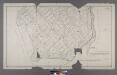
Section 5 of Final Maps and Profiles, of the 23rd & 24th Wards.
from Maps or plans and profiles, with field notes and explanatory remarks, showing the location, width, grades, and class of streets, roads, avenues, public squares and places, located and laid out by the Commissioner of Street Improvements of the 23rd and 24th wards of the city of New York : under authority of Chapter 545 of the laws of 1890.
Part of the Borough of Queens, Flushing, Ward 3.
from Atlas of the city of New York, borough of Queens, Long Island City, Newtown, Flushing, Jamaica, Far Rockaway, from actual surveys and official plans / by George W. and Walter S. Bromley.
Sheet 36: Grid #28000E - 32000E, #5000S - 9000S. [Includes Baxter Creek Estuary, [Ferry Point Park].]
from Topographical survey sheets of the borough of the Bronx easterly of the Bronx River.