Maps of Bronx County
7A - N.Y. City (Aerial Set).
from Sectional aerial maps of the City of New York / [photographed and assembled under the direction of the chief engineer, July 1st, 1924].
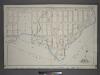
Bronx, V. A, Plate No. 28 [Map bounded by Westchester Creek, Turnbull Ave., Havemeyer Ave., Ludlow Ave.]
From Vol. A
Planning Grid of the Office of the Topographical Bureau of Bronx.
from Topographical survey sheets of the borough of the Bronx easterly of the Bronx River.
Planning Grid of the Office of the Topographical Bureau of Bronx.
from Topographical survey sheets of the borough of the Bronx easterly of the Bronx River.
Sheet 22: Grid #20000E - 24000E, #9000S - 13000S. [Includes Clason's Point Road (Soundview Avenue),(Harding Park) Randall Avenue, (White Plains Road) and Lafayette Avenue.]
from Topographical survey and new street system of the borough of the Bronx, easterly of the Bronx River
Sheet 36: Grid #28000E - 32000E, #5000S - 9000S. [Includes Baxter Creek Estuary, [Ferry Point Park].]
from Topographical survey sheets of the borough of the Bronx easterly of the Bronx River.
Sheet 32: Grid #24000E - 28000E, #5000S - 9000S. [Includes from 1st Street to 10th Street, from Westchester Creek to Avenue B, Union Port, (St. Raymond's Cemetery) and Westchester Avenue.]
from Topographical survey sheets of the borough of the Bronx easterly of the Bronx River.
Planning Grid of the Office of the Topographical Bureau of Bronx.
from Topographical survey sheets of the borough of the Bronx easterly of the Bronx River.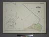
Plate 37, Part of Section 10, Borough of the Bronx. [Bounded by Viele Avenue and East River.]
from Atlas of borough of the Bronx, Sections 9 10 11 12 & 13 : from actual surveys and official plans / G.W. Bromley and Co.
Planning Grid of the Office of the Topographical Bureau of Bronx.
from Topographical survey and new street system of the borough of the Bronx, easterly of the Bronx River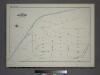
Plate 36, Part of Section 10, Borough of the Bronx. [Bounded by Edgewater Road, Viele Avenue, Farragut Street and Randall Street.]
from Atlas of borough of the Bronx, Sections 9 10 11 12 & 13 : from actual surveys and official plans / G.W. Bromley and Co.
Area District Map Section No. 7
from Area district map / City of New York, Board of Estimate and Apportionment.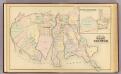
West Chester, Schuylerville.
1 : 14400 Bromley, George Washington; Bromley, Walter Scott; G.W. Bromley & Co.
Use District Map Section No. 7; Use district map / City of New York, Board of Estimate and Apportionment.
from Use district map / City of New York, Board of Estimate and Apportionment. New York (N.Y.). Board of Estimate and Apportionment,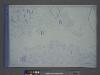
Height District Map Section No. 7; Height district map / City of New York, Board of Estimate and Apportionment.
from Height district map / City of New York, Board of Estimate and Apportionment. New York (N.Y.). Board of Estimate and Apportionment,
Planning Grid of the Office of the Topographical Bureau of Bronx.
from Topographical survey and new street system of the borough of the Bronx, easterly of the Bronx River
Unionport, Schuylerville.
from County atlas of Westchester, New York. Published by J.B. Beers & Co., assisted by S.W. Wilson and others.
Plate 16: Unionport - Westchester - Schuyerville :Town & County of Westchester, N.Y.
from Atlas of New York and vicinity : from actual surveys / by and under the direction of F. W. Beers, assisted by A. B. Prindle & others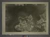
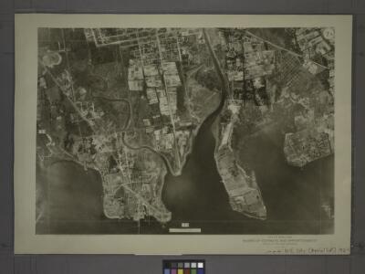
7C - N.Y. City (Aerial Set).
from Sectional aerial maps of the City of New York / [photographed and assembled under the direction of the chief engineer, July 1st, 1924].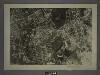
4C - N.Y. City (Aerial Set).
from Sectional aerial maps of the City of New York / [photographed and assembled under the direction of the chief engineer, July 1st, 1924].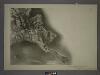
7B - N.Y. City (Aerial Set).
from Sectional aerial maps of the City of New York / [photographed and assembled under the direction of the chief engineer, July 1st, 1924].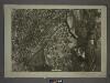
6B - N.Y. City (Aerial Set).
from Sectional aerial maps of the City of New York / [photographed and assembled under the direction of the chief engineer, July 1st, 1924].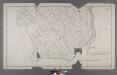
Section 5 of Final Maps and Profiles, of the 23rd & 24th Wards.
from Maps or plans and profiles, with field notes and explanatory remarks, showing the location, width, grades, and class of streets, roads, avenues, public squares and places, located and laid out by the Commissioner of Street Improvements of the 23rd and 24th wards of the city of New York : under authority of Chapter 545 of the laws of 1890.
Planning Grid of the Office of the Topographical Bureau of Bronx.
from Topographical survey and new street system of the borough of the Bronx, easterly of the Bronx River
Unionport, Westchester and Schuylerville, New York.
1 : 8910 Beers, J.B.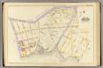
3, ward 23.
1 : 1800 Bromley, George Washington; Bromley, Walter Scott; G.W. Bromley & Co.
Planning Grid of the Office of the Topographical Bureau of Bronx.
from Topographical survey and new street system of the borough of the Bronx, easterly of the Bronx River
Sheet 37: Grid #28000E - 32000E, #1000S - 5000S. [Includes Taber Avenue, Fort Schuyler Road, Town Dock Road and Eastchester Bay.]
from Topographical survey sheets of the borough of the Bronx easterly of the Bronx River.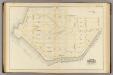
18, ward 23.
1 : 2400 Bromley, George Washington; Bromley, Walter Scott; G.W. Bromley & Co.