Maps of Bronx County

Planning Grid of the Office of the Topographical Bureau of Bronx.
from Topographical survey and new street system of the borough of the Bronx, easterly of the Bronx River
7B - N.Y. City (Aerial Set).
from Sectional aerial maps of the City of New York / [photographed and assembled under the direction of the chief engineer, July 1st, 1924].
7A - N.Y. City (Aerial Set).
from Sectional aerial maps of the City of New York / [photographed and assembled under the direction of the chief engineer, July 1st, 1924].
Bronx, V. A, Plate No. 28 [Map bounded by Westchester Creek, Turnbull Ave., Havemeyer Ave., Ludlow Ave.]
From Vol. A
Planning Grid of the Office of the Topographical Bureau of Bronx.
from Topographical survey sheets of the borough of the Bronx easterly of the Bronx River.
Sheet 32: Grid #24000E - 28000E, #5000S - 9000S. [Includes from 1st Street to 10th Street, from Westchester Creek to Avenue B, Union Port, (St. Raymond's Cemetery) and Westchester Avenue.]
from Topographical survey sheets of the borough of the Bronx easterly of the Bronx River.
Sheet 36: Grid #28000E - 32000E, #5000S - 9000S. [Includes Baxter Creek Estuary, [Ferry Point Park].]
from Topographical survey sheets of the borough of the Bronx easterly of the Bronx River.
Sheet 39: Grid #32000E - 36000E, #3000S - 5000S. [Includes East Chester, Weir Creek, New Pennyfield Road, Greene Avenue, Morgan Avenue, Pennyfield Road, Chester Bay [Edgewater Park], Washington Place and Stevens Place.]
from Topographical survey sheets of the borough of the Bronx easterly of the Bronx River.
Planning Grid of the Office of the Topographical Bureau of Bronx.
from Topographical survey and new street system of the borough of the Bronx, easterly of the Bronx River
Planning Grid of the Office of the Topographical Bureau of Bronx.
from Topographical survey sheets of the borough of the Bronx easterly of the Bronx River.
Sheet 37: Grid #28000E - 32000E, #1000S - 5000S. [Includes Taber Avenue, Fort Schuyler Road, Town Dock Road and Eastchester Bay.]
from Topographical survey sheets of the borough of the Bronx easterly of the Bronx River.
Area District Map Section No. 7
from Area district map / City of New York, Board of Estimate and Apportionment.
Key Continued
From Atlas 141. Vol. 5, 1903.
Use District Map Section No. 7; Use district map / City of New York, Board of Estimate and Apportionment.
from Use district map / City of New York, Board of Estimate and Apportionment. New York (N.Y.). Board of Estimate and Apportionment,
Height District Map Section No. 7; Height district map / City of New York, Board of Estimate and Apportionment.
from Height district map / City of New York, Board of Estimate and Apportionment. New York (N.Y.). Board of Estimate and Apportionment,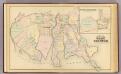
West Chester, Schuylerville.
1 : 14400 Bromley, George Washington; Bromley, Walter Scott; G.W. Bromley & Co.
Unionport, Schuylerville.
from County atlas of Westchester, New York. Published by J.B. Beers & Co., assisted by S.W. Wilson and others.
Plate 16: Unionport - Westchester - Schuyerville :Town & County of Westchester, N.Y.
from Atlas of New York and vicinity : from actual surveys / by and under the direction of F. W. Beers, assisted by A. B. Prindle & others
4D - N.Y. City (Aerial Set).
from Sectional aerial maps of the City of New York / [photographed and assembled under the direction of the chief engineer, July 1st, 1924].
Unionport, Westchester and Schuylerville, New York.
1 : 8910 Beers, J.B.
7D - N.Y. City (Aerial Set).
from Sectional aerial maps of the City of New York / [photographed and assembled under the direction of the chief engineer, July 1st, 1924].
Sheet 31: Grid #24000E - 28000E, #1000S - 5000S. [Includes Union Port, Bowne Estate, Westchester Terrace, St. Raymond's Cemetery and Schuylerville.]
from Topographical survey sheets of the borough of the Bronx easterly of the Bronx River.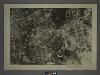
4C - N.Y. City (Aerial Set).
from Sectional aerial maps of the City of New York / [photographed and assembled under the direction of the chief engineer, July 1st, 1924].
Planning Grid of the Office of the Topographical Bureau of Bronx.
from Topographical survey and new street system of the borough of the Bronx, easterly of the Bronx River
Planning Grid of the Office of the Topographical Bureau of Bronx.
from Topographical survey sheets of the borough of the Bronx easterly of the Bronx River.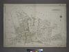
Part of the Borough of Queens, Flushing, Ward 3.
from Atlas of the city of New York, borough of Queens, Long Island City, Newtown, Flushing, Jamaica, Far Rockaway, from actual surveys and official plans / by George W. and Walter S. Bromley.
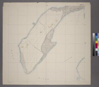
Map of Beechhurst (Whitestone Landing)situated in the third ward, Borough of Queens, City of New York.
From Queens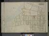
Queens, Vol. 3, Double Page Plate No. 13; Part of Ward Three Whitestone; [Map bounded by 14th Ave., Bayside Ave., 12th Ave., 8th Ave., Irving PL., 11th Ave., Whitestone Ave., 2nd PL., Boulevard, Post PL., Schuyler Ave., 7th Ave., Croton Ave
from Third ward: Flushing.
Sheet 22: Grid #20000E - 24000E, #9000S - 13000S. [Includes Clason's Point Road (Soundview Avenue),(Harding Park) Randall Avenue, (White Plains Road) and Lafayette Avenue.]
from Topographical survey and new street system of the borough of the Bronx, easterly of the Bronx River