Maps of Bronx County

Maps of Bronx County

$title$

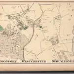
Unionport, Westchester and Schuylerville, New York.

1 : 8910 Beers, J.B.
$title$

Plate 16: Unionport - Westchester - Schuyerville :Town & County of Westchester, N.Y.

from Atlas of New York and vicinity : from actual surveys / by and under the direction of F. W. Beers, assisted by A. B. Prindle & others
$title$

Unionport, Schuylerville.

from County atlas of Westchester, New York. Published by J.B. Beers & Co., assisted by S.W. Wilson and others.
$title$

4C - N.Y. City (Aerial Set).

from Sectional aerial maps of the City of New York / [photographed and assembled under the direction of the chief engineer, July 1st, 1924].
$title$

Bronx, V. A, Plate No. 28 [Map bounded by Westchester Creek, Turnbull Ave., Havemeyer Ave., Ludlow Ave.]

From Vol. A
$title$

Sheet 31: Grid #24000E - 28000E, #1000S - 5000S. [Includes Union Port, Bowne Estate, Westchester Terrace, St. Raymond's Cemetery and Schuylerville.]

from Topographical survey sheets of the borough of the Bronx easterly of the Bronx River.
$title$

Planning Grid of the Office of the Topographical Bureau of Bronx.

from Topographical survey sheets of the borough of the Bronx easterly of the Bronx River.
$title$

Planning Grid of the Office of the Topographical Bureau of Bronx.

from Topographical survey sheets of the borough of the Bronx easterly of the Bronx River.
$title$

Planning Grid of the Office of the Topographical Bureau of Bronx.

from Topographical survey and new street system of the borough of the Bronx, easterly of the Bronx River
$title$

Sheet 38: Grid #26000E - 30000E, #3000N - 7000N. [Includes Eastchester Bay, Pelham Bay Park [Country Club], Town Dock Road, East Road, South Road and North Road.]

from Topographical survey sheets of the borough of the Bronx easterly of the Bronx River.
$title$

Unionport, W. Chester.

1 : 4800 Bromley, George Washington; Bromley, Walter Scott; G.W. Bromley & Co.
$title$

Sheet 37: Grid #28000E - 32000E, #1000S - 5000S. [Includes Taber Avenue, Fort Schuyler Road, Town Dock Road and Eastchester Bay.]

from Topographical survey sheets of the borough of the Bronx easterly of the Bronx River.
$title$

Bronx, V. A, Plate No. 32 [Map bounded by Glebe Ave., St. Peter's St., Seabury Ave., Waterbury Ave., Glover St.]

From Vol. A
$title$

Planning Grid of the Office of the Topographical Bureau of Bronx.

from Topographical survey sheets of the borough of the Bronx easterly of the Bronx River.
$title$

Sheet 32: Grid #24000E - 28000E, #5000S - 9000S. [Includes from 1st Street to 10th Street, from Westchester Creek to Avenue B, Union Port, (St. Raymond's Cemetery) and Westchester Avenue.]

from Topographical survey sheets of the borough of the Bronx easterly of the Bronx River.
$title$

Sheet 18: Grid #16000E - 20000E, #1000S - 5000S. [Includes Morris Park Race Track, Morris Avenue, West Farms Road (Van Nest Station and Morris Park Station Rail Yards) and E. Tremont Avenue.]

from Topographical survey sheets of the borough of the Bronx easterly of the Bronx River.
$title$

Bronx, V. 3, Double Page Plate No. 26 [Map bounded by West Farms Rd., Castle Hill Ave., McGraw Ave., Beach Ave.] / by George W. and Walter S. Bromley.

From Vol. 3
$title$

Height District Map Section No. 4; Height district map / City of New York, Board of Estimate and Apportionment.

from Height district map / City of New York, Board of Estimate and Apportionment. New York (N.Y.). Board of Estimate and Apportionment,
$title$

Use District Map Section No. 4; Use district map / City of New York, Board of Estimate and Apportionment.

from Use district map / City of New York, Board of Estimate and Apportionment. New York (N.Y.). Board of Estimate and Apportionment,
$title$

West Chester, Schuylerville.

1 : 14400 Bromley, George Washington; Bromley, Walter Scott; G.W. Bromley & Co.
$title$

4D - N.Y. City (Aerial Set).

from Sectional aerial maps of the City of New York / [photographed and assembled under the direction of the chief engineer, July 1st, 1924].
$title$

Sheet 17: Grid #16000E - 20000E, #1000S - 3000N. [Includes Morris Park Race Track, (Westchester Square) and Westchester Heights.]

from Topographical survey sheets of the borough of the Bronx easterly of the Bronx River.
$title$

Sheet 19: Grid #16000E - 20000E, #5000S - 9000S. [Includes Westchester Avenue (Parkchester),Tremont Avenue, West Farms Road, Pugsley Street, Tompkin Street (White Plains Road) and Union Post Road.]

from Topographical survey and new street system of the borough of the Bronx, easterly of the Bronx River
$title$

Sheet 36: Grid #28000E - 32000E, #5000S - 9000S. [Includes Baxter Creek Estuary, [Ferry Point Park].]

from Topographical survey sheets of the borough of the Bronx easterly of the Bronx River.
$title$

Sheet 22: Grid #20000E - 24000E, #9000S - 13000S. [Includes Clason's Point Road (Soundview Avenue),(Harding Park) Randall Avenue, (White Plains Road) and Lafayette Avenue.]

from Topographical survey and new street system of the borough of the Bronx, easterly of the Bronx River
$title$

Bronx, V. A, Plate No. 4 [Map bounded by Fowler Ave., Morris Park Ave., Unionport Rd., Neil Ave.]

From Vol. A
$title$

Area District Map Section No. 4

from Area district map / City of New York, Board of Estimate and Apportionment.
$title$

Westchester, Pelham towns.

1 : 21120 Bien, Joseph Rudolf
$title$

Hammods Atlas of New York City and the metropolitan district

$title$

Flushing

1 : 24000
$title$

Flushing

1 : 24000
$title$

Flushing

1 : 24000
$title$

Flushing

1 : 24000
$title$

Flushing

1 : 24000
$title$

Flushing

1 : 24000
$title$

Flushing

1 : 24000
$title$

Flushing

1 : 24000
$title$

Flushing

1 : 24000
© MapTiler © OpenStreetMap contributors
How does it work?
These instructions will show you how to find historical maps online.
Getting started
Type the place name in the search box to find the exact location. You can further adjust the search by zooming in and out.
Zoom
Zoom in and out with the buttons or use your mouse or touchpad natively.
Exact Area tool
Click here and draw a rectangle over the map to precisely define the search area.
Set filters
Narrow your search with advanced settings, such as Years (from/to), Fulltext, Publisher, etc.
Results
See the results of your search on the right side. You can scroll down to find more maps of this location.
?

Download OldMapsOnline Mobile