Maps of Queens County
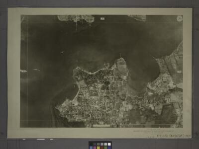
7C - N.Y. City (Aerial Set).
from Sectional aerial maps of the City of New York / [photographed and assembled under the direction of the chief engineer, July 1st, 1924].
College Point.
from Atlas of Queens Co., Long Island, New York / compiled from official records, private plans & actual surveys by and under the direction of Chester Wolverton.
[Plate 23: Bounded by (East River) Avenue G, North Boulevard, N. 20th Street, Avenue C, Boulevard Drive, South Point, Circle Boulevard Drive, Malba Drive, 18th Street, Third Avenue, N. 22nd Street, Fourth Avenue, 5th Street, Third Avenue, First Street, F
from Atlas of the city of New York, borough of Queens, Long Island City, Newtown, Flushing, Jamaica, Far Rockaway, from actual surveys and official plans / by George W. and Walter S. Bromley.
Part of College Point, Town of Flushing, Queens Co.
from Atlas of Long Island, New York. From recent and actual surveys and records.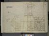
Queens, Vol. 3, Double Page Plate No. 2; Part of ward Three College Point. [Map bounded by Morris Greek, Caugeway, Vanwycks Lane, North Boulevard, Avenue G, Avenue F, Avenue D, Avenue C, East Boulevard, Schleicher Court, Third Ave., Lawre
from Third ward: Flushing.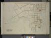
Queens, Vol. 3, Double Page Plate No. 1; Part of ward Three College Point. [Map bounded by Avenue G, North Boulevard, Van Wycks Lane, College Ave., West Boulevard, First Ave., Bradish Ave., Second Ave., Nichols Ave., Third Ave., Fourth Ave., Fift
from Third ward: Flushing.
Planning Grid of the Office of the Topographical Bureau of Bronx.
from Topographical survey sheets of the borough of the Bronx easterly of the Bronx River.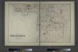
Part of College Point. Town of Flushing, Queens Co.
from Atlas of Long Island, New York. From recent and actual surveys and records.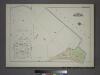
Plate 37, Part of Section 10, Borough of the Bronx. [Bounded by Viele Avenue and East River.]
from Atlas of borough of the Bronx, Sections 9 10 11 12 & 13 : from actual surveys and official plans / G.W. Bromley and Co.
Area District Map Section No. 7
from Area district map / City of New York, Board of Estimate and Apportionment.
Use District Map Section No. 7; Use district map / City of New York, Board of Estimate and Apportionment.
from Use district map / City of New York, Board of Estimate and Apportionment. New York (N.Y.). Board of Estimate and Apportionment,
Height District Map Section No. 7; Height district map / City of New York, Board of Estimate and Apportionment.
from Height district map / City of New York, Board of Estimate and Apportionment. New York (N.Y.). Board of Estimate and Apportionment,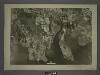
7A - N.Y. City (Aerial Set).
from Sectional aerial maps of the City of New York / [photographed and assembled under the direction of the chief engineer, July 1st, 1924].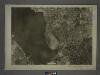
10A - N.Y. City (Aerial Set).
from Sectional aerial maps of the City of New York / [photographed and assembled under the direction of the chief engineer, July 1st, 1924].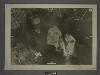
6D - N.Y. City (Aerial Set).
from Sectional aerial maps of the City of New York / [photographed and assembled under the direction of the chief engineer, July 1st, 1924].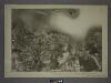
7D - N.Y. City (Aerial Set).
from Sectional aerial maps of the City of New York / [photographed and assembled under the direction of the chief engineer, July 1st, 1924].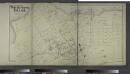
Part of Whitestone Village. Town of Flushing, Queens Co. L.I. [Covers from 3rd Avenue to 17th Avenue, and Boulevard to 17th Street.]
from Atlas of Long Island, New York. From recent and actual surveys and records.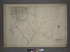
Part of the Borough of Queens, Flushing, Ward 3.
from Atlas of the city of New York, borough of Queens, Long Island City, Newtown, Flushing, Jamaica, Far Rockaway, from actual surveys and official plans / by George W. and Walter S. Bromley.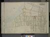
Queens, Vol. 3, Double Page Plate No. 13; Part of Ward Three Whitestone; [Map bounded by 14th Ave., Bayside Ave., 12th Ave., 8th Ave., Irving PL., 11th Ave., Whitestone Ave., 2nd PL., Boulevard, Post PL., Schuyler Ave., 7th Ave., Croton Ave
from Third ward: Flushing.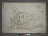
Part of the Borough of Queens, Flushing, Ward 3.
from Atlas of the city of New York, borough of Queens, Long Island City, Newtown, Flushing, Jamaica, Far Rockaway, from actual surveys and official plans / by George W. and Walter S. Bromley.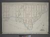
Plate 19: Part of Section 10, Borough of the Bronx. [Bounded by Viele Avenue, Edgewater Road and Coster Street.]
from Atlas and owners names, borough of the Bronx, sections 9 & 10 : from actual surveys and official plans / by George W. and Walter S. Bromley.
Planning Grid of the Office of the Topographical Bureau of Bronx.
from Topographical survey sheets of the borough of the Bronx easterly of the Bronx River.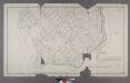
Section 5 of Final Maps and Profiles, of the 23rd & 24th Wards.
from Maps or plans and profiles, with field notes and explanatory remarks, showing the location, width, grades, and class of streets, roads, avenues, public squares and places, located and laid out by the Commissioner of Street Improvements of the 23rd and 24th wards of the city of New York : under authority of Chapter 545 of the laws of 1890.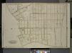
Queens, Vol. 3, Double Page Plate No. 12; Part of Ward Three Whitestone; [Map bounded by 14th Ave., Haggertys Lane, 11th Ave., Clinton Pl., Cryders Lane, 10th Ave., 9th Ave., 8th Ave., 7th Ave., 5th Ave., 4th Ave., Tatham Pl., Private, Howl
from Third ward: Flushing.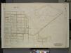
Queens, Vol. 3, Double Page Plate No. 3; Part of Ward Three College Point. [Map bounded by Fifth Ave., Sixth Ave., Seventh Ave., Eighth Ave., East Eighth Ave., East Ninth Ave., E. 10th Ave., 10th Ave., Victoria PL.; Including 21st St., 2
from Third ward: Flushing.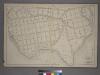
Plate 21: [Bounded by Winslow St., Tiffany St., Grinnell Pl., Hunts Point Ave., Sacrahong St., Strain Pl., Edgewater Rd., Ely St., Coster Ave., Casanova St. and Conover Ave.]
from Atlas of the city of New York : from official records, private plans & actual surveys / compiled under the supervision of E. Robinson & R. H. Pidgeon.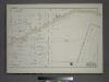
Plate 34, Part of Section 10, Borough of the Bronx. [Bounded by Farragut Street, Ryawa Avenue, Longfellow Avenue and East Bay Avenue.]
from Atlas of borough of the Bronx, Sections 9 10 11 12 & 13 : from actual surveys and official plans / G.W. Bromley and Co.
Key Continued
From Atlas 141. Vol. 5, 1903.
Key Continued
From Atlas 137. Vol. 3, 1902.