Maps of Passaic County
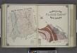
Geological Map of Passaic County, New Jersey.
from Atlas of Passaic County, New-Jersey : topographical, geological, historical, illustrated ; from actual surveys of each township and village / under the supervision of the publishers, assisted by the able engineers of Paterson.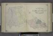
Outline Map of Passaic County, New Jersey.
from Atlas of Passaic County, New-Jersey : topographical, geological, historical, illustrated ; from actual surveys of each township and village / under the supervision of the publishers, assisted by the able engineers of Paterson.
New jersey
Baker, Harriet E.
Outline and Index Map of Atlas of New York City.
from Atlas of the borough of Manhattan, city of New York.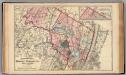
Bergen, Passaic Cos., N.J.
1 : 126720 Beers, F. W. (Frederick W.)
New Jersey, Double Page Sheet No. 7 [Map of Northeastern Red Sandstone]
From Atlas of New Jersey.
4 NE Highlands.
1 : 63360 Vermeule, C. C. (Cornelius Clarkson), 1858-1950
7 NE red sandstone.
1 : 63360 Vermeule, C. C. (Cornelius Clarkson), 1858-1950
Watson's new map of the city of Brooklyn including Brooklyn
From Brooklyn
Township of West Milford [Township]
from Atlas of Passaic County, New-Jersey : topographical, geological, historical, illustrated ; from actual surveys of each township and village / under the supervision of the publishers, assisted by the able engineers of Paterson.
Paterson, N.J. - N.Y., ed. of Feb. 1903, repr. 1924
from New Jersey, 15 minute series (topographic) / mapped, edited, and published by the Geological Survey.
Map of Coney Island and Sheepshead Bay
From Brooklyn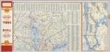
(Metropolitan New York and Long Island) Northern Section. To and Through Manhattan.
Shell Oil Company
New York, Brooklyn.
1 : 42500 Beers, F. W. (Frederick W.)
General map of the city of New York, consisting of boroughs of Manhattan, Brooklyn, Bronx, Queens and Richmond : consolidated into one municipality by act of the legislature of the state of New York (Chapter 378 of the laws of 1897) : showing in addition
from Whole
Morristown
1 : 62500
Morristown
1 : 62500
Morristown
1 : 62500
Morristown
1 : 62500
Morristown
1 : 62500
Paterson
1 : 62500
Paterson
1 : 62500
Paterson
1 : 62500
Paterson
1 : 62500
Paterson
1 : 62500
Paterson
1 : 62500
Paterson
1 : 62500
Paterson
1 : 62500
Paterson
1 : 62500
Morristown
1 : 62500
Morristown
1 : 62500
Paterson
1 : 62500
Morristown
1 : 62500
Morristown
1 : 62500


