Maps of Queens County
24D - N.Y. City (Aerial Set).
from Sectional aerial maps of the City of New York / [photographed and assembled under the direction of the chief engineer, July 1st, 1924].
Area District Map Section No. 24; Area district map / City of New York, Board of Estimate and Apportionment.
from Area district map / City of New York, Board of Estimate and Apportionment. New York (N.Y.). Board of Estimate and Apportionment,
Use District Map Section No. 24; Use district map / City of New York, Board of Estimate and Apportionment.
from Use district map / City of New York, Board of Estimate and Apportionment. New York (N.Y.). Board of Estimate and Apportionment,
Height District Map Section No. 24; Height district map / City of New York, Board of Estimate and Apportionment.
from Height district map / City of New York, Board of Estimate and Apportionment. New York (N.Y.). Board of Estimate and Apportionment,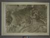
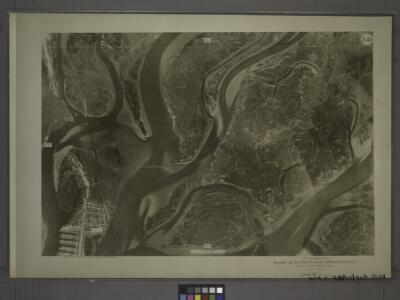
24B - N.Y. City (Aerial Set).
from Sectional aerial maps of the City of New York / [photographed and assembled under the direction of the chief engineer, July 1st, 1924].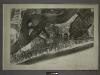
30B - N.Y. City (Aerial Set).
from Sectional aerial maps of the City of New York / [photographed and assembled under the direction of the chief engineer, July 1st, 1924].
Queens, Vol. 1, Double Page Plate No. 35; Part of Ward 5; Rockaway; [Map bounded by Jamaica Bay, Charmttoir Island, Mc. Caffertys Island, Nortons Creek, Hudson Ave., Columbus Ave., Rochester Ave., Wave Crest Ave., Surf Ave., Grand-View Ave., B
from Fourth and fifth wards: Jamaica and Rockaway.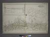
Part of the Borough of Queens, Far Rockaway, Ward 5.
from Atlas of the city of New York, borough of Queens, Long Island City, Newtown, Flushing, Jamaica, Far Rockaway, from actual surveys and official plans / by George W. and Walter S. Bromley.
Queens V. 8, Plate No. 1 [Map bounded by Jamaica Bay, Dunbar]
From Atlas 145a. Vol. 8, 1912.
Key
From Atlas 145a. Vol. 8, 1912.
Far Rockaway
1 : 24000
Far Rockaway
1 : 24000
Far Rockaway
1 : 24000
Far Rockaway
1 : 24000
Key
From Atlas 145a. Vol. 8, 1912.
Height District Map Section No. 30
from Height district map / City of New York, Board of Estimate and Apportionment.
Area District Map Section No. 30
from Area district map / City of New York, Board of Estimate and Apportionment.
24C - N.Y. City (Aerial Set).
from Sectional aerial maps of the City of New York / [photographed and assembled under the direction of the chief engineer, July 1st, 1924].
25C - N.Y. City (Aerial Set).
from Sectional aerial maps of the City of New York / [photographed and assembled under the direction of the chief engineer, July 1st, 1924].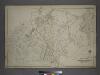
Part of the Borough of Queens, Jamaica, Ward 4.
from Atlas of the city of New York, borough of Queens, Long Island City, Newtown, Flushing, Jamaica, Far Rockaway, from actual surveys and official plans / by George W. and Walter S. Bromley.
Use District Map Section No. 30; Use district map / City of New York, Board of Estimate and Apportionment.
from Use district map / City of New York, Board of Estimate and Apportionment. New York (N.Y.). Board of Estimate and Apportionment,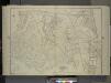
Queens, Vol. 1, Double Page Plate No. 19; Part Of Ward 4; Jamaica; [Map bounded by Conduit Long Island R.R., Boundary Line Of The City of New York; Including Hook Canal Creek, Jamaica Bay, Dead or Salt Creek.]; Sub Plan From Plate No. 17 [Map bou
from Fourth and fifth wards: Jamaica and Rockaway.
24A - N.Y. City (Aerial Set).
from Sectional aerial maps of the City of New York / [photographed and assembled under the direction of the chief engineer, July 1st, 1924].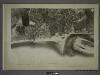
31A - N.Y. City (Aerial Set).
from Sectional aerial maps of the City of New York / [photographed and assembled under the direction of the chief engineer, July 1st, 1924].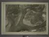
30A - N.Y. City (Aerial Set).
from Sectional aerial maps of the City of New York / [photographed and assembled under the direction of the chief engineer, July 1st, 1924].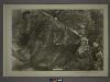
25A - N.Y. City (Aerial Set).
from Sectional aerial maps of the City of New York / [photographed and assembled under the direction of the chief engineer, July 1st, 1924].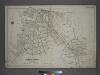
[Plate 45: Bounded by Horton Place, Remsen Avenue, Central Avenue, (Inlet, Atlantic Ocean), John Street, Bay Avenue, Rochester Avenue, Spray View Avenue, Neptune Avenue, Boulevard, Channel Avenue, Ocean Avenue, Cornaga Avenue, Healey Avenue, Bayview Aven
from Atlas of the city of New York, borough of Queens, Long Island City, Newtown, Flushing, Jamaica, Far Rockaway, from actual surveys and official plans / by George W. and Walter S. Bromley.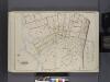
Queens, V. 1, Double Page Plate No. 23; Part of Far Rockaway, Ward 5; [Map bounded by Cornell Ave., Clinton Ave., Mott Ave., Central Ave., Bay Ave., Norton's Creek]
From Fourth and fifth wards: Jamaica and Rockaway.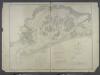
Jamaica Bay and Rockaway Inlet, Long Island, New York.
from U.S. Coast and Geodetic Survey. Nautical chart ; no. 542.