Maps of Queens County
24A - N.Y. City (Aerial Set).
from Sectional aerial maps of the City of New York / [photographed and assembled under the direction of the chief engineer, July 1st, 1924].
Queens, V. 1, Double Page Plate No. 16; Part of Jamaica, Ward 4; [Map bounded by Dunham Ave., Canal Ave., Morrell Ave., Jamaica Bay, Spring Creek] / by and under the supervision of Hugo Ullitz.
From v. 1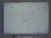
Area District Map Section No. 24; Area district map / City of New York, Board of Estimate and Apportionment.
from Area district map / City of New York, Board of Estimate and Apportionment. New York (N.Y.). Board of Estimate and Apportionment,
Use District Map Section No. 24; Use district map / City of New York, Board of Estimate and Apportionment.
from Use district map / City of New York, Board of Estimate and Apportionment. New York (N.Y.). Board of Estimate and Apportionment,
Height District Map Section No. 24; Height district map / City of New York, Board of Estimate and Apportionment.
from Height district map / City of New York, Board of Estimate and Apportionment. New York (N.Y.). Board of Estimate and Apportionment,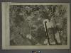
18C - N.Y. City (Aerial Set).
from Sectional aerial maps of the City of New York / [photographed and assembled under the direction of the chief engineer, July 1st, 1924].
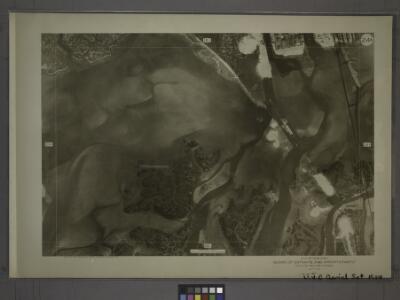
24C - N.Y. City (Aerial Set).
from Sectional aerial maps of the City of New York / [photographed and assembled under the direction of the chief engineer, July 1st, 1924].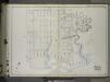
Brooklyn, Vol. 1, 2nd Part, Double Page Plate No. 50; Part of Wards 26, Section 14; [Map bounded by Vandalia Ave., Fountain Ave., Vandalia Ave.; Including Spring Creek, Jamaica Bay, Jerome St.] / by and under the direction of Hugo Ullitz.
From Volume 1, part 2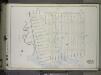
Brooklyn, Vol. 1, 2nd Part, Double Page Plate No. 49; Part of Wards 26, Section 14; [Map bounded by Vandalia Ave., Cleveland St., Border Ave., Louisiana Ave., Fresh or First Creek; Including Malta St., Alabama Ave., Georgia Ave., Sheffield Ave.] / by ...
From Volume 1, part 2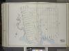
Brooklyn, Vol. 1, 2nd Part, Double Page Plate No. 49; Part of Wards 26, Section 14; [Map bounded by Vandalia Ave., Cleveland St., Border Ave., Louisiana Ave., Fresh or First Creek; Including Malta St., Alabama Ave., Georgia Ave., Sheffield Ave.] / by ...
From Volume 1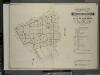
Index to Volume Four. Atlas of the Borough of Brooklyn. Sections 12, 13 & 14. Wards 26 and part of 29 & 32. City of New York. E. Belcher Hyde, 97 Liberty St., Brooklyn Borough. 1904.
from Wards 26 and part of 29 & 32.
New Lots. Kings Co. L.I.
from Atlas of Long Island, New York. From recent and actual surveys and records.
Jamaica
1 : 24000
Jamaica
1 : 24000
Jamaica
1 : 24000
Jamaica
1 : 24000
Jamaica
1 : 24000
Jamaica
1 : 24000
Community resources
From District 5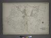
[Plate 40: Bounded by Old South Road, Centerville Avenue, Rockway Plank Road, Road to Bergens Landing, Old South Road, (Jamaica Bay, Vanderveers Island, Hortsmans Island &c.) Conduit Road and Cedar Lane.]
from Atlas of the city of New York, borough of Queens, Long Island City, Newtown, Flushing, Jamaica, Far Rockaway, from actual surveys and official plans / by George W. and Walter S. Bromley.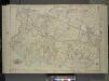
Queens, Vol. 1, Double Page Plate No. 17; Part of Ward 4; Jamaica; [Map bounded by Liberty Ave., Rockaway Turnpike, Mile Hill Road; Including Corn Fill Creek, Spring Creek]
from Fourth and fifth wards: Jamaica and Rockaway.
Spring Creek -- Linear City. (cont.)
From Spring Creek -- Linear City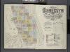
Insurance Maps of the Brooklyn city of New York Volume Eight. Published by the Sanborn map co. 117, Broadway, New York. 1887.
From Atlas 86. Vol. 8, 1887.
24B - N.Y. City (Aerial Set).
from Sectional aerial maps of the City of New York / [photographed and assembled under the direction of the chief engineer, July 1st, 1924].
23B - N.Y. City (Aerial Set).
from Sectional aerial maps of the City of New York / [photographed and assembled under the direction of the chief engineer, July 1st, 1924].
Plate 40: Bounded by Duryea Avenue, Bennet Avenue, New Lots Road, Ruby Street, Cozine Avenue, Grant Avenue, Flatlands Avenue, Lincoln Avenue, Van Wicklen Avenue, Louisiana Avenue, Flatlands Avenue, Rockaway Parkway, Rockaway Avenue, Vanderveer Avenue and
from Robinson's atlas of the city of Brooklyn, New York : embracing all territory within its corporate limits; from official records ... / by and under the supervision of E. Robinson and R.H. Pidgeon, civil engineers.
Height District Map Section No. 18; Height district map / City of New York, Board of Estimate and Apportionment.
from Height district map / City of New York, Board of Estimate and Apportionment. New York (N.Y.). Board of Estimate and Apportionment,
Use District Map Section No. 18; Use district map / City of New York, Board of Estimate and Apportionment.
from Use district map / City of New York, Board of Estimate and Apportionment. New York (N.Y.). Board of Estimate and Apportionment,
Area District Map Section No. 18; Area district map / City of New York, Board of Estimate and Apportionment.
from Area district map / City of New York, Board of Estimate and Apportionment. New York (N.Y.). Board of Estimate and Apportionment,