Maps of Kings County

Spring Creek -- Linear City. (cont.)
From Spring Creek -- Linear City
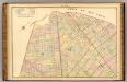
New Lots. Kings Co. L.I.
from Atlas of Long Island, New York. From recent and actual surveys and records.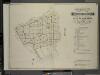
Index to Volume Four. Atlas of the Borough of Brooklyn. Sections 12, 13 & 14. Wards 26 and part of 29 & 32. City of New York. E. Belcher Hyde, 97 Liberty St., Brooklyn Borough. 1904.
from Wards 26 and part of 29 & 32.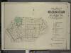
Index to Volume Five. Atlas of the Borough of Brooklyn. Sections 15 & 16. Ward 29 and part of 32. City of New York. E. Belcher Hyde, 97 Liberty St., Brooklyn Borough. 1906.
from Ward 29 and part of 32.
Community resources
From District 5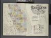
Insurance Maps of the Brooklyn city of New York Volume Eight. Published by the Sanborn map co. 117, Broadway, New York. 1887.
From Atlas 86. Vol. 8, 1887.
Area Zoning Map Section No. 17
From Area zoning map of the city of New York, compiled in the Dept. of City Planning, Division of Mapping and Zoning, May 27, 1953. Irving F. Ashworth, senior civil engineer.
Brooklyn, Double Page Section 9; East New York; [Map bounded by Eldert Lane, Liberty Ave., Bennett Ave., New Lots Road, Duryea Ave., Centre Ave., Stmarks Ave., Saratoga Ave., Cooper PL., Mc. Dougal St.; Including Hopkinson Ave., Rockaway Ave., Gran
from Farm line map of the city of Brooklyn, from official records and surveys; comp. and drawn by Henry Fulton.
Brooklyn, Double Page Section 7; [Including Wards 18, 24, 25]
from Farm line map of the city of Brooklyn, from official records and surveys; comp. and drawn by Henry Fulton.
Area District Map Section No. 23; Area district map / City of New York, Board of Estimate and Apportionment.
from Area district map / City of New York, Board of Estimate and Apportionment. New York (N.Y.). Board of Estimate and Apportionment,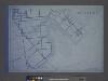
Use District Map Section No. 23; Use district map / City of New York, Board of Estimate and Apportionment.
from Use district map / City of New York, Board of Estimate and Apportionment. New York (N.Y.). Board of Estimate and Apportionment,
Height District Map Section No. 23; Height district map / City of New York, Board of Estimate and Apportionment.
from Height district map / City of New York, Board of Estimate and Apportionment. New York (N.Y.). Board of Estimate and Apportionment,
Area District Map Section No. 17; Area district map / City of New York, Board of Estimate and Apportionment.
from Area district map / City of New York, Board of Estimate and Apportionment. New York (N.Y.). Board of Estimate and Apportionment,
Use District Map Section No. 17; Use district map / City of New York, Board of Estimate and Apportionment.
from Use district map / City of New York, Board of Estimate and Apportionment. New York (N.Y.). Board of Estimate and Apportionment,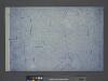
Height District Map Section No. 17; Height district map / City of New York, Board of Estimate and Apportionment.
from Height district map / City of New York, Board of Estimate and Apportionment. New York (N.Y.). Board of Estimate and Apportionment,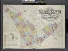
Insurance Maps of the Brooklyn city of New York Volume Seven. Published by the Sanborn map co. 117, Broadway, New York. 1888.
From Atlas 83. Vol. 7, 1888.
Sheet 4: Map encompassing Ocean Hill, Broasway Junction, Bushwick and Ridgewood.
from Map of the city of Brooklyn : being the former cities of Brooklyn & Williamsburgh and the town of Bushwick, as consolidated January 1st, 1855 by an act of the legislature of the State of New York ... showing also a part of the City of New York.
Plan of the city of Brooklyn, L.I. / by William Perris.
from Brooklyn
Plan of the city of Brooklyn, L.I. / by William Perris.
from Brooklyn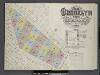
Insurance Maps of the Brooklyn city of New York Volume Five. Published by the Sanborn map co. 117, Broadway, New York. 1888.
From Atlas 77. Vol. 5, 1888.
Key
From Atlas 137a. Vol. 3, 1914.
Plan of the city of Brooklyn, L.I. / by William Perris.
from Brooklyn
Plate 40: Bounded by Duryea Avenue, Bennet Avenue, New Lots Road, Ruby Street, Cozine Avenue, Grant Avenue, Flatlands Avenue, Lincoln Avenue, Van Wicklen Avenue, Louisiana Avenue, Flatlands Avenue, Rockaway Parkway, Rockaway Avenue, Vanderveer Avenue and
from Robinson's atlas of the city of Brooklyn, New York : embracing all territory within its corporate limits; from official records ... / by and under the supervision of E. Robinson and R.H. Pidgeon, civil engineers.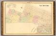
Sec. 9 East New York.
1 : 6000 Fulton, Henry; J.B. Beers & Co.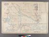
Plate 31: [Bounded by Avenue K, E. 103rd Street, Avenue N, E. 98th Street, (Bulkhead Line) Denton Avenue, (Paerdegat Basin) Paerdegat Avenue, E. 76th Street, Avenue Y, (Bulkhead Line) E. 69th Street, Avenue T and Ralph Avenue.]
from Robinson's atlas of Kings County, New York : compiled from official records ... / under the direction of E. Robinson.
Canarsie. Town of Flat Lands, Kings Co.
from Atlas of Long Island, New York. From recent and actual surveys and records.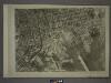
17D - N.Y. City (Aerial Set).
from Sectional aerial maps of the City of New York / [photographed and assembled under the direction of the chief engineer, July 1st, 1924].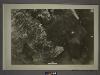
23B - N.Y. City (Aerial Set).
from Sectional aerial maps of the City of New York / [photographed and assembled under the direction of the chief engineer, July 1st, 1924].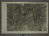
17B - N.Y. City (Aerial Set).
from Sectional aerial maps of the City of New York / [photographed and assembled under the direction of the chief engineer, July 1st, 1924].