Maps of Queens County
Height District Map Section No. 18; Height district map / City of New York, Board of Estimate and Apportionment.
from Height district map / City of New York, Board of Estimate and Apportionment. New York (N.Y.). Board of Estimate and Apportionment,
Use District Map Section No. 18; Use district map / City of New York, Board of Estimate and Apportionment.
from Use district map / City of New York, Board of Estimate and Apportionment. New York (N.Y.). Board of Estimate and Apportionment,
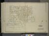
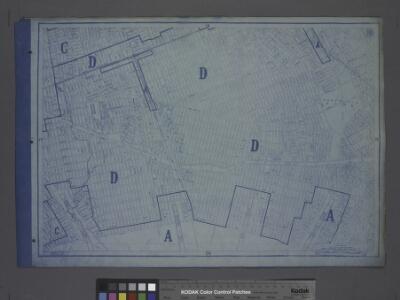
Area District Map Section No. 18; Area district map / City of New York, Board of Estimate and Apportionment.
from Area district map / City of New York, Board of Estimate and Apportionment. New York (N.Y.). Board of Estimate and Apportionment,
Queens, Vol. 1, Double Page Plate No. 17; Part of Ward 4; Jamaica; [Map bounded by Liberty Ave., Rockaway Turnpike, Mile Hill Road; Including Corn Fill Creek, Spring Creek]
from Fourth and fifth wards: Jamaica and Rockaway.
[Plate 40: Bounded by Old South Road, Centerville Avenue, Rockway Plank Road, Road to Bergens Landing, Old South Road, (Jamaica Bay, Vanderveers Island, Hortsmans Island &c.) Conduit Road and Cedar Lane.]
from Atlas of the city of New York, borough of Queens, Long Island City, Newtown, Flushing, Jamaica, Far Rockaway, from actual surveys and official plans / by George W. and Walter S. Bromley.
Queens V. 6, Plate No. 104 [Map bounded by 155th St., 159th St., Conduit]
From Atlas 142a, Vol. 6, 1911.
18B - N.Y. City (Aerial Set).
from Sectional aerial maps of the City of New York / [photographed and assembled under the direction of the chief engineer, July 1st, 1924].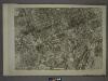
18A - N.Y. City (Aerial Set).
from Sectional aerial maps of the City of New York / [photographed and assembled under the direction of the chief engineer, July 1st, 1924].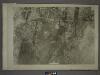
18D - N.Y. City (Aerial Set).
from Sectional aerial maps of the City of New York / [photographed and assembled under the direction of the chief engineer, July 1st, 1924].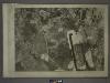
18C - N.Y. City (Aerial Set).
from Sectional aerial maps of the City of New York / [photographed and assembled under the direction of the chief engineer, July 1st, 1924].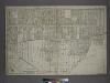
Part of the Borough of Queens, Jamaica, Ward 4.
from Atlas of the city of New York, borough of Queens, Long Island City, Newtown, Flushing, Jamaica, Far Rockaway, from actual surveys and official plans / by George W. and Walter S. Bromley.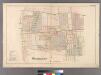
Woodhaven, Town of Jamaica.
from Atlas of Queens Co., Long Island, New York / compiled from official records, private plans & actual surveys by and under the direction of Chester Wolverton.
Queens, Vol. 1, Double Page Plate No. 21; Part of Ward 4; [Map bounded by Metropolis Ave., Mill St., Vansicklen Ave., Sutter Ave., Chestnut St.; Including Metropolis Ave., Grant Ave., Rockaway Plank Road, Clinton Ave.]; Sub Plan From Plate
from Fourth and fifth wards: Jamaica and Rockaway.
Queens, Vol. 1, Double Page Plate No. 22; Part of Ward 4; [Map bounded by Road to Landing, Ocean Ave.; Including Freeland Ave.]; Sub Plan From Plate No. 17; [Map bounded by New York and Rockaway Beach R.R., Road to Remsens Landing; Including
from Fourth and fifth wards: Jamaica and Rockaway.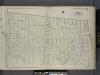
Queens, V. 1, Double Page Plate No. 14; Part of Jamaica, Ward 4; [Map bounded by Liberty Ave., Vanderveer Ave., Hegeman Ave., Spring Creek, Ruby St.] / by and under the supervision of Hugo Ullitz.
From v. 1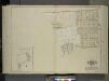
Queens, Vol. 1, Double Page Plate No. 23; Part of Ward 4; Jamaica; [Map bounded by Rockaway Plank road, Three Mile Mill Road, Old South Road; Including Smith St., Sidney St., Lewis St., Bank St., Bedford St.]; Sub Plan From Plate 17, Book 6, Pla
from Fourth and fifth wards: Jamaica and Rockaway.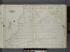
Queens, V. 1, Double Page Plate No. 15; Part of Jamaica, Ward 4; [Map bounded by Hegeman Ave., Woodhaven Ave., Dunham Ave., Spring Creek] / by and under the supervision of Hugo Ullitz.
From v. 1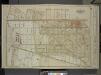
Queens, Vol. 1, Double Page Plate No. 2; Part of Ward Four, Jamaica; [Map bounded by Borough of Brooklyn, Elderst Lane, Drew Ave., Center Ave., Snedeker Ave., Rockaway Plank Road, Dakota Ave., Shaw Ave., Nevada Ave., Montana Ave., Fulton Ave., Be
from Fourth and fifth wards: Jamaica and Rockaway.
Queens, V. 1, Double Page Plate No. 2; Part of Jamaica, Ward 4; [Map bounded by Pitkin Pl., Hopkinton Ave., Liberty Ave., Elderts Ln.]
From Fourth and fifth wards: Jamaica and Rockaway.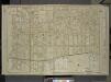
Queens, Vol. 1, Double Page Plate No. 3; Part of Ward Four, Jamaica; [Map bounded by Atlantic Ave., Napier Ave., Ocean Ave., Hopkinton Ave., Woodhaven Ave., Flushing Ave., Grafton Ave., Hatch Ave., Shattuck Ave., Oakley Ave., Lawn Ave., Union Ave.,
from Fourth and fifth wards: Jamaica and Rockaway.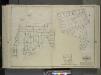
Queens, Vol. 1, Double Page Plate No. 25; Part of Ward 4; Jamaica; [Map bounded by Liberty Ave., Road to Landing, Whitelaw Ave., Arion St., Albert St., Spritz St., Old South Road, Sutter Ave., Vajen PL., Egbert PL., Dalrymple Ave., Glenmor
from Fourth and fifth wards: Jamaica and Rockaway.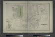
Woodhaven, Town of Jamaica, Queens Co. - South Woodhaven, Town of Jamaica, Queens Co.
from Atlas of Long Island, New York. From recent and actual surveys and records.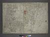
[Plate 31: Bounded by New York and Rockaway Beach, Ocean Avenue, Freeland Avenue, Flushing (Woodhaven) Avenue, Sutter Avenue, Cedar Lane, Conduit, Ruby Street, Atlantic Avenue, Drew Avenue, and (Crest Park) Brooklyn and Jamaica Plank Avenue.]
from Atlas of the city of New York, borough of Queens, Long Island City, Newtown, Flushing, Jamaica, Far Rockaway, from actual surveys and official plans / by George W. and Walter S. Bromley.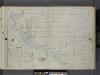
Queens, V. 1, Double Page Plate No. 16; Part of Jamaica, Ward 4; [Map bounded by Dunham Ave., Canal Ave., Morrell Ave., Jamaica Bay, Spring Creek] / by and under the supervision of Hugo Ullitz.
From v. 1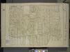
Queens, Vol. 1, Double Page Plate No. 6; Part of Ward 4, Jamaica; [Map bounded by Atlantic Ave., Jefferson Ave., Briggs Ave., Johnson Ave., Lefferts Ave., Chichester Ave., Broadway, Belmont Ave., Liberty Ave., Morris Ave., Maure Ave., Frost Ave.
from Fourth and fifth wards: Jamaica and Rockaway.
Part of Ward 26. Land Map Section, No. 14. Volume 1, Brooklyn Borough, New York City.
from Atlas of the Brooklyn borough of the City of New York : originally Kings Co.; complete in three volumes ... based upon official maps and plans ... / by and under the supervision of Hugo Ullitz, C.E.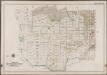
Plate 41: [Bounded by Linwood St., Cozine Ave., Shepherd Ave., Vienna Ave., Berriman St., Hegeman Ave., Milford St., Glenmore Ave., Ruby St., Belmont Ave., Drew Ave., Hegeman Ave., Saphire St., Vienna Ave., Amber St., Stanley Ave., Emerald St., Cozine Ave., Ruby Ave., Fairfield Ave. & Vandalia Ave.]; Atlas of the borough of Brooklyn, city of New York: from actual surveys and official plans by George W. and Walter S. Bromley.
from Atlas of the borough of Brooklyn, city of New York : from actual surveys and official plans by George W. and Walter S. Bromley. G.W. Bromley & Co.,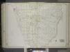
Brooklyn, Vol. 1, 2nd Part, Double Page Plate No. 46; Part of Wards 26, Section 14; [Map bounded by Dumont Ave., boundary line of the boroughs of Brooklyn and Queens, Vandalia Ave.; Including Crescent St., Fairfield Ave., Fountain Ave.] / by and under...
From Volume 1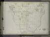
Brooklyn, Vol. 1, 2nd Part, Double Page Plate No. 46; Part of Wards 26, Section 14; [Map bounded by Dumont Ave., boundary line of the boroughs of Brooklyn and Queens, Vandalia Ave.; Including Crescent St., Fairfield Ave., Fountain Ave.] / by and under...
From Volume 1, part 2