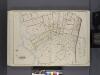
Maps of Queens County
30B - N.Y. City (Aerial Set).
from Sectional aerial maps of the City of New York / [photographed and assembled under the direction of the chief engineer, July 1st, 1924].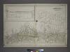
Part of the Borough of Queens, Far Rockaway, Ward 5.
from Atlas of the city of New York, borough of Queens, Long Island City, Newtown, Flushing, Jamaica, Far Rockaway, from actual surveys and official plans / by George W. and Walter S. Bromley.
Queens, Vol. 1, Double Page Plate No. 35; Part of Ward 5; Rockaway; [Map bounded by Jamaica Bay, Charmttoir Island, Mc. Caffertys Island, Nortons Creek, Hudson Ave., Columbus Ave., Rochester Ave., Wave Crest Ave., Surf Ave., Grand-View Ave., B
from Fourth and fifth wards: Jamaica and Rockaway.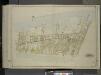
Queens, Vol. 1, Double Page Plate No. 37; Part of Ward 5; Farrockaway; [Remsen Ave., Henry St., Hollywood Ave., Wolcott Ave., Judson Ave., Ward Ave., Thompson Ave., Bond Ave., Waverly Ave., Academy Ave.; Including Holland Ave., Oceanus Ave
from Fourth and fifth wards: Jamaica and Rockaway.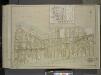
Queens, Vol. 1, Double Page Plate No. 36; Sub Plan; [Map bounded by Isabel Ave., Amstel Canal; Including Grand Ave., Boulevard.]; Part of Ward 5; Farrockaway; [Map bounded by Amstel Boulevard, Alexander Ave., Seaview Ave., Amerman Ave., Meredit
from Fourth and fifth wards: Jamaica and Rockaway.
Queens V. 8, Plate No. 80 [Map bounded by Atlantic Ocean, Beach 105th St., Rockaway Beach Blvd.]
From Atlas 145a. Vol. 8, 1912.
Queens V. 8, Plate No. 77 [Map bounded by Beach 100th St., Rockaway Beach Blvd., Beach 105th St., Jamaica Bay]
From Atlas 145a. Vol. 8, 1912.
Area District Map Section No. 30
from Area district map / City of New York, Board of Estimate and Apportionment.
Height District Map Section No. 30
from Height district map / City of New York, Board of Estimate and Apportionment.
Key
From Atlas 145a. Vol. 8, 1912.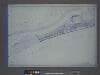
Use District Map Section No. 30; Use district map / City of New York, Board of Estimate and Apportionment.
from Use district map / City of New York, Board of Estimate and Apportionment. New York (N.Y.). Board of Estimate and Apportionment,
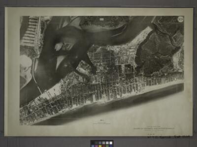
24D - N.Y. City (Aerial Set).
from Sectional aerial maps of the City of New York / [photographed and assembled under the direction of the chief engineer, July 1st, 1924].
30D - N.Y. City (Aerial Set).
from Sectional aerial maps of the City of New York / [photographed and assembled under the direction of the chief engineer, July 1st, 1924].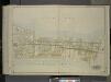
Queens, Vol. 1, Double Page Plate No. 38; Part of Ward 5; Farrockaway; [Map bounded by bay Ave., 10th Ave., 9th Ave., 8th Ave., 7th Ave., 6th Ave., 5th Ave., 4th Ave., 3rd Ave., 2nd Ave., 1st Ave.; Including New Port Ave., Beach Ave., Eastern
from Fourth and fifth wards: Jamaica and Rockaway.
Far Rockaway
1 : 24000
Far Rockaway
1 : 24000
Far Rockaway
1 : 24000
Far Rockaway
1 : 24000
Key
From Atlas 145a. Vol. 8, 1912.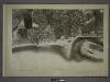
31A - N.Y. City (Aerial Set).
from Sectional aerial maps of the City of New York / [photographed and assembled under the direction of the chief engineer, July 1st, 1924].
30A - N.Y. City (Aerial Set).
from Sectional aerial maps of the City of New York / [photographed and assembled under the direction of the chief engineer, July 1st, 1924].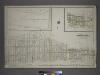
Part of the Borough of Queens, Far Rockaway, Ward 5.
from Atlas of the city of New York, borough of Queens, Long Island City, Newtown, Flushing, Jamaica, Far Rockaway, from actual surveys and official plans / by George W. and Walter S. Bromley.
Area District Map Section No. 24; Area district map / City of New York, Board of Estimate and Apportionment.
from Area district map / City of New York, Board of Estimate and Apportionment. New York (N.Y.). Board of Estimate and Apportionment,
Use District Map Section No. 24; Use district map / City of New York, Board of Estimate and Apportionment.
from Use district map / City of New York, Board of Estimate and Apportionment. New York (N.Y.). Board of Estimate and Apportionment,
Height District Map Section No. 24; Height district map / City of New York, Board of Estimate and Apportionment.
from Height district map / City of New York, Board of Estimate and Apportionment. New York (N.Y.). Board of Estimate and Apportionment,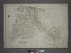
[Plate 45: Bounded by Horton Place, Remsen Avenue, Central Avenue, (Inlet, Atlantic Ocean), John Street, Bay Avenue, Rochester Avenue, Spray View Avenue, Neptune Avenue, Boulevard, Channel Avenue, Ocean Avenue, Cornaga Avenue, Healey Avenue, Bayview Aven
from Atlas of the city of New York, borough of Queens, Long Island City, Newtown, Flushing, Jamaica, Far Rockaway, from actual surveys and official plans / by George W. and Walter S. Bromley.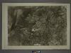
25C - N.Y. City (Aerial Set).
from Sectional aerial maps of the City of New York / [photographed and assembled under the direction of the chief engineer, July 1st, 1924].
24C - N.Y. City (Aerial Set).
from Sectional aerial maps of the City of New York / [photographed and assembled under the direction of the chief engineer, July 1st, 1924].
30C - N.Y. City (Aerial Set).
from Sectional aerial maps of the City of New York / [photographed and assembled under the direction of the chief engineer, July 1st, 1924].