Maps of Woodmere
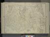
Queens, Vol. 1, Double Page Plate No. 19; Part Of Ward 4; Jamaica; [Map bounded by Conduit Long Island R.R., Boundary Line Of The City of New York; Including Hook Canal Creek, Jamaica Bay, Dead or Salt Creek.]; Sub Plan From Plate No. 17 [Map bou
from Fourth and fifth wards: Jamaica and Rockaway.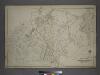
Part of the Borough of Queens, Jamaica, Ward 4.
from Atlas of the city of New York, borough of Queens, Long Island City, Newtown, Flushing, Jamaica, Far Rockaway, from actual surveys and official plans / by George W. and Walter S. Bromley.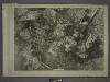
19C - N.Y. City (Aerial Set).
from Sectional aerial maps of the City of New York / [photographed and assembled under the direction of the chief engineer, July 1st, 1924].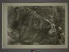
25A - N.Y. City (Aerial Set).
from Sectional aerial maps of the City of New York / [photographed and assembled under the direction of the chief engineer, July 1st, 1924].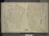
Queens, Vol. 1, Double Page Plate No. 20; Part of Ward 4; Jamaica; Sub Plan From Plate No. 19; Rosedale; [Map bounded by Plaza Mill Ave.; Including Ocean Ave.]; Sub Plan From Plate No. 18; Springfield; [Map bounded by Merrick Rd., Compton Pl.
from Fourth and fifth wards: Jamaica and Rockaway.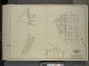
Queens, Vol. 1, Double Page Plate No. 31; Part of Ward 4; Jamaica; [Map bounded by Farmers Ave., New York Ave., Belvedere Ave., Chalfonte Ave., Road to Powells Mill, Pleasant PL.; Including 4th St., 5th St., 6th St., 7th St., 8th St., 9th St.,
from Fourth and fifth wards: Jamaica and Rockaway.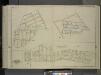
Queens, Vol. 1, Double Page Plate No. 28; Part of Ward 4; Jamaica; [Map bounded by Broadway Turnpike, Vermont Way, tennessee Way, Dakota Way, Oregon Way, Idaho Ave., Wyoming Ave., Virginia Way, Alabama Way, Nebraska Way, Florida Way; Includin
from Fourth and fifth wards: Jamaica and Rockaway.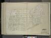
Queens, Vol. 1, Double Page Plate No. 41; Part of Ward 4; [Map bounded by Merrick Road, Road to Wrights Mill, Hampton Road, Darmouth Road, Cam Bridge Road, Calumet PL., Oxford Road, Gildersleeve Ave.; Including Westminster Boulevard, Ar
from Fourth and fifth wards: Jamaica and Rockaway.
Rosedale Gardens
from Atlas of Nassau County, Long Island, N.Y. Complete in one volume. Historical, statistical. Based upon maps on file at the county seat in Mineola and upon private plans and surveys furnished by surveyors and individual owners. Supplemented by careful measurements & field observations by our own corps of engineers.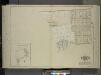
Queens, Vol. 1, Double Page Plate No. 23; Part of Ward 4; Jamaica; [Map bounded by Rockaway Plank road, Three Mile Mill Road, Old South Road; Including Smith St., Sidney St., Lewis St., Bank St., Bedford St.]; Sub Plan From Plate 17, Book 6, Pla
from Fourth and fifth wards: Jamaica and Rockaway.
Inwood, Cedarhurst Vicinity
from Atlas of Nassau County, Long Island, N.Y. Complete in one volume. Historical, statistical. Based upon maps on file at the county seat in Mineola and upon private plans and surveys furnished by surveyors and individual owners. Supplemented by careful measurements & field observations by our own corps of engineers.
Springfield Store. Tn. of Jamaica, Queens Co. - Willow Tree Station. Town of Jamaica, Queens Co. - Inglewood or Queens. Town of Hempstead, Queens Co.
from Atlas of Long Island, New York. From recent and actual surveys and records.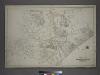
Part of the Borough of Queens, Jamaica, Ward 4.
from Atlas of the city of New York, borough of Queens, Long Island City, Newtown, Flushing, Jamaica, Far Rockaway, from actual surveys and official plans / by George W. and Walter S. Bromley.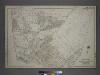
[Plate 42: Bounded by Central Avenue, (Springfield, Laurelton, Rosedale Terrace) Springfield Road, (Springfield Park, High View Park, Higbie Park), Higbie Avenue, Farmers Avenue, Merrick Plank Road, Locust Avenue and (Locust Manor, Cedar Manor) Smith Ave
from Atlas of the city of New York, borough of Queens, Long Island City, Newtown, Flushing, Jamaica, Far Rockaway, from actual surveys and official plans / by George W. and Walter S. Bromley.
Height District Map Section No. 25; Height district map / City of New York, Board of Estimate and Apportionment.
from Height district map / City of New York, Board of Estimate and Apportionment. New York (N.Y.). Board of Estimate and Apportionment,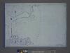
Area District Map Section No. 25; Area district map / City of New York, Board of Estimate and Apportionment.
from Area district map / City of New York, Board of Estimate and Apportionment. New York (N.Y.). Board of Estimate and Apportionment,
Use District Map Section No. 25; Use district map / City of New York, Board of Estimate and Apportionment.
from Use district map / City of New York, Board of Estimate and Apportionment. New York (N.Y.). Board of Estimate and Apportionment,
Queens, Vol. 1, Double Page Plate No. 18; Part of Ward 4; Jamaica; [Map bounded by South St., Country Road, Old Country Road, Jamaica Plank Road; Including Boundary Line Of City Of New York, Ocean Ave., Farmers Ave., Rockaway Turnpike, Th
from Fourth and fifth wards: Jamaica and Rockaway.
Height District Map Section No. 19; Height district map / City of New York, Board of Estimate and Apportionment.
from Height district map / City of New York, Board of Estimate and Apportionment. New York (N.Y.). Board of Estimate and Apportionment,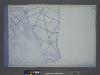
Use District Map Section No. 19; Use district map / City of New York, Board of Estimate and Apportionment.
from Use district map / City of New York, Board of Estimate and Apportionment. New York (N.Y.). Board of Estimate and Apportionment,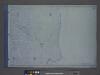
Area District Map Section No. 19; Area district map / City of New York, Board of Estimate and Apportionment.
from Area district map / City of New York, Board of Estimate and Apportionment. New York (N.Y.). Board of Estimate and Apportionment,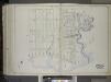
Brooklyn, Vol. 1, 2nd Part, Double Page Plate No. 50; Part of Wards 26, Section 14; [Map bounded by Vandalia Ave., Fountain Ave., Vandalia Ave.; Including Spring Creek, Jamaica Bay, Jerome St.] / by and under the direction of Hugo Ullitz.
From Volume 1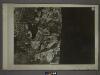
19D - N.Y. City (Aerial Set).
from Sectional aerial maps of the City of New York / [photographed and assembled under the direction of the chief engineer, July 1st, 1924].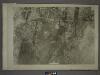
18D - N.Y. City (Aerial Set).
from Sectional aerial maps of the City of New York / [photographed and assembled under the direction of the chief engineer, July 1st, 1924].
24B - N.Y. City (Aerial Set).
from Sectional aerial maps of the City of New York / [photographed and assembled under the direction of the chief engineer, July 1st, 1924].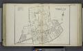
Cedarhurst
from Atlas of Nassau County, Long Island, N.Y. Complete in one volume. Historical, statistical. Based upon maps on file at the county seat in Mineola and upon private plans and surveys furnished by surveyors and individual owners. Supplemented by careful measurements & field observations by our own corps of engineers.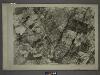
19A - N.Y. City (Aerial Set).
from Sectional aerial maps of the City of New York / [photographed and assembled under the direction of the chief engineer, July 1st, 1924].
Queens V. 6, Plate No. 104 [Map bounded by 155th St., 159th St., Conduit]
From Atlas 142a, Vol. 6, 1911.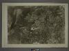
25C - N.Y. City (Aerial Set).
from Sectional aerial maps of the City of New York / [photographed and assembled under the direction of the chief engineer, July 1st, 1924].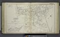
![Queens, Vol. 1, Double Page Plate No. 19; Part Of Ward 4; Jamaica; [Map bounded by Conduit Long Island R.R., Boundary Line Of The City of New York; Including Hook Canal Creek, Jamaica Bay, Dead or Salt Creek.]; Sub Plan From Plate No. 17 [Map bou](https://images-2.georeferencer.com/images/iiif/720906234619/full/,300/0/native.jpg)

