Maps of Primorje-Gorski Kotar County

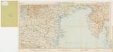
Unie und Sansego.
from Spezialkarte der osterreichisch-ungarischen Monarchie.
Zone 27, Kol. X, Unie und Sansego, uit: Geologische Karte der im Reichsrathe vertretenen Königreiche und Länder der Österreich-Ungarischen Monarchie : auf Grundlage der Specialkarte i.M. 1:75.000 des k.u.k. Militär-geographischen Institutes / neu bearb. und als Kartenwerk von 341 Blattnummern in zwanglosen Lfg. hrsg. durch die k.k. Geologische Reichsanstalt in Wien
1 : 75000 titelvariant: Geologische Spezialkarte der im Reichsrate vertretenen Königreiche und Länder der Österreichisch-Ungarischen Monarchie; Geologische Specialkarte der im Reichsrathe vertretenen Königreiche und Länder der Österreichisch-Ungarischen Monarchie; Annotatie: Titel bovenaan kaartblad: Geologische Spezialkarte der im Reichsrate vertretenen Königreiche und Länder der Österreichisch-Ungarischen Monarchie en Geologische Specialkarte der im Reichsrathe vertretenen Königreiche und Länder der Österreichisch-Ungarischen Monarchie; Annotatie geografische gegevens: Coördinaten gebaseerd op nulmeridiaan van Ferro (Hierro) Kaiserlich-Königliche Geologische Reichsanstalt, Wenen Wien : K.K. Geologische Reichsanstalt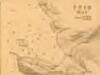
Plan of Ports in the Adriatic - Unie Bay

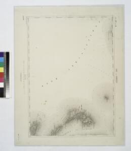
Skelet-Karte für Curs-Skizzen
Chorvatsko K. u. k. Kriegs-Marine
Pola und Lubenizze.
from Spezialkarte der osterreichisch-ungarischen Monarchie.
Istrien
1 : 80000 Cres (Chorvatsko) Oesterreicher, T. Hydrographisches Amt der K. u. k. Kriegs-Marine, Seekarten-Depot
Lussin
1 : 200000 Kroatien Lošinj
Generalkarte von Zentraleuropa

Die adriatische Küste von Pola bis Zara
1 : 900000 Kroatien Adriaküste
Oesterreichische Riviera

Karte der Kronländer Görz mit Gradisca und Istrien und der reichsunmittelbaren Stadt Triest mit deren politischen und gerichtlichen Eintheilung
Gorice a Gradiška Kettner, Vincenz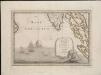
Lo Stato Veneto da terra diviso nelle sue provincie, quarta parte che compren de porzioni del Dogado e dell' Istria.
1 : 536000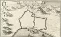
Grondtris der Statt Zeng
Mollova mapová sbírka Merian, Matthaeus Merian, Matthäus
Carta del litorale Austriaco
Istrijský poloostrov (Slovinsko a Chorvatsko) Schwarzer von Heldenstamm, Ernst
Karte des k. k. Küstenlandes
Chorvatsko Kettner, Vinzenz Förster, L.
Adriatisches Meer, Küsten-Karte
1 : 180000 Istrijský poloostrov (Slovinsko a Chorvatsko) Oesterreicher, Tobias von Hydrographisches Amt der k. u. k. Kriegs-Marine
Carta del litorale Austriaco
1 : 440000 Istrijský poloostrov (Slovinsko a Chorvatsko) Schwarzer, Ernesto de
Pulj
1 : 200000 Pula (Chorvatsko) Kartografska radionica
Physikalische Karte des Quarnero nach Dr. J. R. Lorenz
1 : 580000 Kroatien, Kvarner Freytag, Gustav

Istrien, Dalmatien
1 : 80000 Dalmácie (Chorvatsko) Oesterreicher, T. Hydrographisches Amt der K. u. k. Kriegsmarine, Seekartendepot
ISTRIA | olim | IAPIDIA.
[Amsterdam : Joan Blaeu]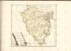

Lussinpiccolo und Punta Loni.
from Spezialkarte der osterreichisch-ungarischen Monarchie.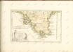

Zone 27, Col. XI, Lussin Piccolo und Puntaloni, uit: Geologische Karte der im Reichsrathe vertretenen Königreiche und Länder der Österreich-Ungarischen Monarchie : auf Grundlage der Specialkarte i.M. 1:75.000 des k.u.k. Militär-geographischen Institutes / neu bearb. und als Kartenwerk von 341 Blattnummern in zwanglosen Lfg. hrsg. durch die k.k. Geologische Reichsanstalt in Wien
1 : 75000 titelvariant: Geologische Spezialkarte der im Reichsrate vertretenen Königreiche und Länder der Österreichisch-Ungarischen Monarchie; Geologische Specialkarte der im Reichsrathe vertretenen Königreiche und Länder der Österreichisch-Ungarischen Monarchie; Annotatie: Titel bovenaan kaartblad: Geologische Spezialkarte der im Reichsrate vertretenen Königreiche und Länder der Österreichisch-Ungarischen Monarchie en Geologische Specialkarte der im Reichsrathe vertretenen Königreiche und Länder der Österreichisch-Ungarischen Monarchie; Annotatie geografische gegevens: Coördinaten gebaseerd op nulmeridiaan van Ferro (Hierro) Kaiserlich-Königliche Geologische Reichsanstalt, Wenen Wien : K.K. Geologische Reichsanstalt
Fasana.
from Spezialkarte der osterreichisch-ungarischen Monarchie.
Cherso und Arbe.
from Spezialkarte der osterreichisch-ungarischen Monarchie.
Selve.
from Spezialkarte der osterreichisch-ungarischen Monarchie.