Maps of Pula

Fasana.
from Spezialkarte der osterreichisch-ungarischen Monarchie.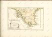

Istrien
1 : 40000 Istrijský poloostrov (Slovinsko a Chorvatsko) Oesterreicher, T. Hydrographisches Amt der K. u. k. Kriegsmarine, Seekartendepot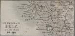
Der Kriegshafen Pula und die Insel Brioni
Pula, Brioni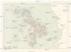
Brionische Inseln
1 : 7500 Brionské ostrovy (Chorvatsko)
Zu Bildner des Heeres Beilage 13
1 : 29300 Pula (Chorvatsko) K.k. Schulbücher-Verschleiss-Administration
Hafen von Pola
1 : 35000 Kroatien Pola Hafen
Plan von Pola
1 : 15000 Kroatien Pola
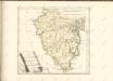
Parenzo und Rovigno.
from Spezialkarte der osterreichisch-ungarischen Monarchie.
Istrien
1 : 60000 Istrijský poloostrov (Slovinsko a Chorvatsko) Oesterreicher, T. Hydrographisches Amt der K. u. k. Kriegsmarine, Seekartendepot
Carta del litorale Austriaco
1 : 440000 Istrijský poloostrov (Slovinsko a Chorvatsko) Schwarzer, Ernesto de
Carta del litorale Austriaco
Istrijský poloostrov (Slovinsko a Chorvatsko) Schwarzer von Heldenstamm, Ernst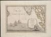
Lo Stato Veneto da terra diviso nelle sue provincie, quarta parte che compren de porzioni del Dogado e dell' Istria.
1 : 536000
Königreich Illyrien Charte des gouvernements Triest
1 : 450000 Ilýrie Renner A. Plott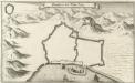
Grondtris der Statt Zeng
Mollova mapová sbírka Merian, Matthaeus Merian, Matthäus
Carta Generale del Regno Lombardo-Veneto e paesi limitrofi... IV.

Istrie
1 : 750000 Machát, František c. a k. voj. zeměpisný ústav

ISTRIA | olim | IAPIDIA.
[Amsterdam : Joan Blaeu]
Karte der Kronländer Görz mit Gradisca und Istrien und der reichsunmittelbaren Stadt Triest mit deren politischen und gerichtlichen Eintheilung
Gorice a Gradiška Kettner, Vincenz
Karte des k. k. Küstenlandes
Chorvatsko Kettner, Vinzenz Förster, L.
Adriatisches Meer, Küstenkarte
1 : 180000 Istrijský poloostrov (Slovinsko a Chorvatsko) Oesterreicher, Tobias von Hydrographisches Amt der k. u. k. Kriegsmarine
Adriatisches Meer, Küsten-Karte
1 : 180000 Istrijský poloostrov (Slovinsko a Chorvatsko) Oesterreicher, Tobias von Hydrographisches Amt der k. u. k. Kriegs-Marine
Istria olim Iapidia [Karte], in: Theatrum orbis terrarum, sive, Atlas novus, Bd. 3, S. 131.
1 Karte aus Atlas Blaeu, Joan Blaeu, Willem Janszoon
Istria olim Iapidia [Karte], in: Le théâtre du monde, ou, Nouvel atlas contenant les chartes et descriptions de tous les païs de la terre, Bd. 3, S. 155.
1 Karte aus Atlas Blaeu, Willem Janszoon und Blaeu, Joan Blaeu, Willem Janszoon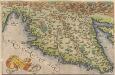
Histriae tabula [Karte], in: Theatrum orbis terrarum, S. 262.
1 Karte aus Atlas Ortelius, Abraham
Istria olim Iapidia [Karte], in: Novus Atlas, das ist, Weltbeschreibung, Bd. 3, S. 151.
1 Karte aus Atlas Blaeu, Joan Blaeu, Willem Janszoon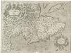
Istria olim Iapidia
1 : 300000 Mollova mapová sbírka Magini, Giovanni Antonio Magini, Fabio