Maps of Istria County

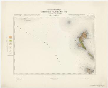
Zone 27, Kol. X, Unie und Sansego, uit: Geologische Karte der im Reichsrathe vertretenen Königreiche und Länder der Österreich-Ungarischen Monarchie : auf Grundlage der Specialkarte i.M. 1:75.000 des k.u.k. Militär-geographischen Institutes / neu bearb. und als Kartenwerk von 341 Blattnummern in zwanglosen Lfg. hrsg. durch die k.k. Geologische Reichsanstalt in Wien
1 : 75000 titelvariant: Geologische Spezialkarte der im Reichsrate vertretenen Königreiche und Länder der Österreichisch-Ungarischen Monarchie; Geologische Specialkarte der im Reichsrathe vertretenen Königreiche und Länder der Österreichisch-Ungarischen Monarchie; Annotatie: Titel bovenaan kaartblad: Geologische Spezialkarte der im Reichsrate vertretenen Königreiche und Länder der Österreichisch-Ungarischen Monarchie en Geologische Specialkarte der im Reichsrathe vertretenen Königreiche und Länder der Österreichisch-Ungarischen Monarchie; Annotatie geografische gegevens: Coördinaten gebaseerd op nulmeridiaan van Ferro (Hierro) Kaiserlich-Königliche Geologische Reichsanstalt, Wenen Wien : K.K. Geologische Reichsanstalt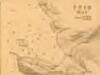
Plan of Ports in the Adriatic - Unie Bay

Unie und Sansego.
from Spezialkarte der osterreichisch-ungarischen Monarchie.
Skelet-Karte für Curs-Skizzen
Chorvatsko K. u. k. Kriegs-Marine
Pulj
1 : 200000 Pula (Chorvatsko) Kartografska radionica
Carta del litorale Austriaco
1 : 440000 Istrijský poloostrov (Slovinsko a Chorvatsko) Schwarzer, Ernesto de
Adriatisches Meer, Küsten-Karte
1 : 180000 Istrijský poloostrov (Slovinsko a Chorvatsko) Oesterreicher, Tobias von Hydrographisches Amt der k. u. k. Kriegs-Marine
Physikalische Karte des Quarnero nach Dr. J. R. Lorenz
1 : 580000 Kroatien, Kvarner Freytag, Gustav
Pola und Lubenizze.
from Spezialkarte der osterreichisch-ungarischen Monarchie.
Istrien, Dalmatien
1 : 80000 Dalmácie (Chorvatsko) Oesterreicher, T. Hydrographisches Amt der K. u. k. Kriegsmarine, Seekartendepot
Istrien
1 : 80000 Cres (Chorvatsko) Oesterreicher, T. Hydrographisches Amt der K. u. k. Kriegs-Marine, Seekarten-Depot
Lussinpiccolo und Punta Loni.
from Spezialkarte der osterreichisch-ungarischen Monarchie.

Karte der Kronländer Görz mit Gradisca und Istrien und der reichsunmittelbaren Stadt Triest mit deren politischen und gerichtlichen Eintheilung
Gorice a Gradiška Kettner, Vincenz
Generalkarte von Zentraleuropa

Die adriatische Küste von Pola bis Zara
1 : 900000 Kroatien Adriaküste
Oesterreichische Riviera

Carta del litorale Austriaco
Istrijský poloostrov (Slovinsko a Chorvatsko) Schwarzer von Heldenstamm, Ernst
Karte des k. k. Küstenlandes
Chorvatsko Kettner, Vinzenz Förster, L.
Lo Stato Veneto da terra diviso nelle sue provincie, quarta parte che compren de porzioni del Dogado e dell' Istria.
1 : 536000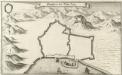
Grondtris der Statt Zeng
Mollova mapová sbírka Merian, Matthaeus Merian, Matthäus
Tabula DUCATUS CARNIOLIAE VINDORUM MARCHIAE et HISTRIAE
1 : 520000 Cirknické jezero (Slovinsko) Homann, Johann Baptist Valvasor, Janez Vajkard â Io. Bapt. Homanno
Tabula ducatus Carnioliae Vindorum Marchiae et Histriae
1 : 510000 Cirknické jezero (Slovinsko) Homann, Johann Baptist Valvasor, L. B. â Io. Bapt. Homanno
Le Cours Du Po
1 : 450000 Mollova mapová sbírka Nolin, Jean-Baptiste Leonard, Jean
Vermehrte und Verbesserte Landkarten des Königreichs Ungarn :
1 : 500000 Mollova mapová sbírka Stier, Martin Böner, Johann-Alexander Endter, Martin
Jonction de la mer Adriatique á la Culpa
1 : 150000 Jaderské moře-oblast
[Slovinsko a Chorvatsko]
1 : 576000 Chorvatsko
Foglio 4, uit: Carta d'Italia alla scala di 1:500.000 / Touring Club Italiano
1 : 500000 Annotatie: Voor aanwezige bladen zie overzichtsblad Touring Club Italiano Milano : Touring Club Italiano
Venizia
1 : 500000 Woerl, Joseph Edmund