Maps of Moray

The East Coast of Scotland with the Isles of Orkney and Shetland.
Collins, Greenvile, fl. 1669-1698
A general map of Scotland and islands thereto belonging, 2
1 Blatt : 91 x 62 cm s.n.
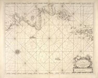
Nieuwe pascaert van de Oost cust van Schotlandt : beginnende van Barwyck tot aen de Orcades Ylanden
1 : 700000 Annotatie: Uit (krt. 24): Nieuwe groote lichtende zee-fakkel ... - Amsterdam : Gerard Hulst van Keulen, 1782 Amsterdam : Iohannes van Ceulen
Scotland III.
1 : 765000 Society for the Diffusion of Useful Knowledge (Great Britain)
Des Königreichs Scotland nördlicher Theil oder Das Hochland
1 Karte : Kupferdruck ; 20 x 26 cm Reilly F. J. J. von Reilly
Scotland (northern sheet).
1 : 633600 Johnston, Alexander Keith
Scotland N.
1 : 633600 Johnston, Alexander Keith, 1804-1871
Scotland NE.
1 : 500000 Cary, John, ca. 1754-1835
De Custen van Schotlandt van Donde tot d'Eijlanden van Orcanesse. De kusten van Schotlandt van Donde tot Eijlanden Orcanesse.
Blaeu, Willem Janszoon, 1571-1638
Carte particuliere de la cote orientale d'Ecosse, depuis St Abb's Head jusqu'a Duncansby Head.
Depot Generale de la Marine, Paris
Nieuwe Pascaert van de oost cust van Schotlandt beginnende van Barwyck tot aen de Orcades Ylanden ... / by Johannes van Ceuylen.
Keulen, Johannes van, 1654-1715
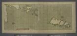
A large draught of the ISLES of ORKNEY with the north part of SCOTLAND
from The sea-atlas : containing an hydrographical description of most of the sea-coasts of the known parts of the world.
L'Ecosse divisee en Shires ou Comtes.
1 : 960000 Robert de Vaugondy, Gilles, 1688-1766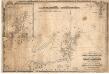
A chart of the north coast of Scotland including the Orkney and Shetland Islands.
Blachford, W.
Scotland NE.
1 : 486830 Stanford, Edward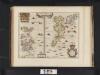
Orcadum et Shetlandiae Insularum accuratissima descriptio.
Blaeu, Willem Janszoon, 1571-1638 Blaeu, Joan, 1596-1673
Chart of Shetland Isles and Orkney Islands
1 : 15000000 Columbine, Edward Henry
Scotiae Provinciae intra Flumen Taum, et Murrafyrth sitae, utpote Moravia, Badenocha, Atholia, Aberdonia, Baneia et Mernis. [Karte], in: Novus atlas absolutissimus, Bd. 8, S. 163.
1 Karte aus Atlas Janssonius Offizin
Scotland II.
1 : 765000 Society for the Diffusion of Useful Knowledge (Great Britain)
[Orkney Islands, Shetland Islands.]
Great Britain. Hydrographic Office
Orcadvm et Schetlandiæ insvlarvm accuratissima descriptio
2 Karten auf 1 Blatt : Kupferdruck ; zusammen 37 x 48 cm Valck; Schenk apud G. Valk et P. Schenk
Orcadvm et Schetlandiæ insvlarvm accuratissima descriptio
2 Karten auf 1 Blatt : Kupferdruck ; zusammen 39 x 52 cm Blaeu; Blaeu Joan Blaeu
Scotland / J. Ainslie, 3
1 Blatt : 67 x 58 cm Ainslie, Faden
Scotland / J. Ainslie, 6
1 Blatt : 67 x 58 cm Ainslie, Faden
Scotiæ provinciæ intra flumen Taum, et Murra fyrth sitæ
1 Karte : Kupferdruck ; 42 x 51 cm Valck; Schenk Gerard Valck et Pieter Schenk
Orcadum et Schetlandiae Insularum accuratissima descriptio. [Karte, Orcades], in: Gerardi Mercatoris et I. Hondii Newer Atlas, oder, Grosses Weltbuch, Bd. 1, S. 69.
1 Karte aus Atlas Mercator, Gerhard und Hondius, Jodocus Jansson, Jan
Nieuwe paskaart van de Orcades Eylanden / door Vooght geometra.
Vooght, Claes Janszoon, d. 1696. Keulen, Johannes van, 1654-1715.
Orcadum et Schetlandiae Insularum accuratissima descriptio. [Karte, Orcades], in: Novus atlas absolutissimus, Bd. 8, S. 180.
1 Karte aus Atlas Janssonius Offizin