Maps of Moray

Scotland NE.
1 : 486830 Stanford, Edward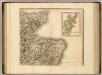
Scotland NE.
1 : 500000 Cary, John, ca. 1754-1835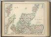
Scotland (northern sheet).
1 : 633600 Johnston, W. & A.K.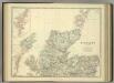
Scotland (northern sheet).
1 : 633600 Johnston, Alexander Keith
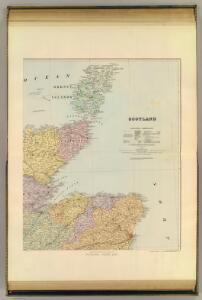
Scotland 2.
1 : 760320 Letts, Son & Co.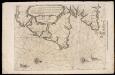
De Custen van Schotlandt van Donde tot d'Eijlanden van Orcanesse. De kusten van Schotlandt van Donde tot Eijlanden Orcanesse.
Blaeu, Willem Janszoon, 1571-1638
Scotland / J. Ainslie, 3
1 Blatt : 67 x 58 cm Ainslie, Faden
Scotiae Provinciae intra Flumen Taum, et Murrafyrth sitae, utpote Moravia, Badenocha, Atholia, Aberdonia, Baneia et Mernis. [Karte], in: Novus atlas absolutissimus, Bd. 8, S. 163.
1 Karte aus Atlas Janssonius Offizin
EXTIMA SCOTIÆ | SEPTENTRIONALIS ORA, | ubi Provinciæ sunt | ROSSIA, SVTHERLANDIA, CATHENESIA, | STRATH-NAVERNIÆ, | cum vicinis regiunculis quæ eis subsunt, etiamque | MORAVIA.
R. Gordonius à Strath-loch collegit et descripsit. [Amsterdam : Joan Blaeu]
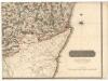
A chart of part of the North of Scotland, from Banff to Duncansby Head.
Ainslie, John, 1745-1828
A chart of part of the North of Scotland, from Banff to Duncansby Head.
Ainslie, John, 1745-1828
A chart of part of the North of Scotland, from Banff to Duncansby Head.
Ainslie, John, 1745-1828
A chart of part of the North of Scotland, from Banff to Duncansby Head.
Ainslie, John, 1745-1828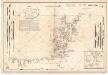
Carte des Isles Orcades.
Depot Generale de la Marine, Paris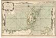
A new chart of the north coast of Scotland with... the Orkney Islands.
Bennett, J. Sayer, R.
Scotland[Motoring Map of]
London : "Geographia
Extimae Scotiae pars Septentrionalis, in qua Provinciae Rossia, Sutherlandia, Cathenesia, et Strath-Naverniae. [Karte], in: Novus atlas absolutissimus, Bd. 8, S. 166.
1 Karte aus Atlas Janssonius Offizin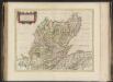
Extima Scotiae septentrionalis ora, ubi Provinciae sunt Rossia, Sutherlandia, Cathenesia, Strath-Naverniae, cum vicinis regiunculis quae eis subsunt, etiamque Moravia / R. Gordonius à Strath-loch coll
Gordon, Robert, 1580-1661 Blaeu, Joan, 1596-1673
Extima Scotiæ septentrionalis ora
1 Karte : Kupferdruck ; 40 x 50 cm Blaeu; Gordon Joan Blaeu
DVO VICECOMITATVS | ABERDONIA & BANFIA, | Una cum Regionibus & terrarum tractibus | sub iis comprehensis. [=] A Description of the two Shyres | ABERDENE and BANF, | With such Countreys and Provinces as ar | comprehended under them.
Auctore Roberto Gordonio à Straloch. [Amsterdam : Joan Blaeu]
Ordnance Survey of Great Britain, Scotland
Ordnance Survey
Ordnance Survey of Great Britain, Scotland
Ordnance Survey
Scotiæ provinciæ intra flumen Taum, et Murra fyrth sitæ
1 Karte : Kupferdruck ; 42 x 51 cm Valck; Schenk Gerard Valck et Pieter Schenk
Orcadum et Schetlandiae Insularum accuratissima descriptio. [Karte, Orcades], in: Novus atlas absolutissimus, Bd. 8, S. 180.
1 Karte aus Atlas Janssonius Offizin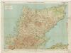
[Kaart], uit: Sutherland & Caithness
1 : 253440 titelvariant: Sutherland and Caithness; Annotatie: Titel op omslag: Sutherland and Caithness; Verso: bladoverzicht reeks Edinburgh : Bartholomew
Orcadum et Schetlandiae Insularum accuratissima descriptio. [Karte, Orcades], in: Gerardi Mercatoris et I. Hondii Newer Atlas, oder, Grosses Weltbuch, Bd. 1, S. 69.
1 Karte aus Atlas Mercator, Gerhard und Hondius, Jodocus Jansson, Jan
Dvo vicecomitatvs Aberdonia [et] Banfia
1 Karte : Kupferdruck ; 41 x 54 cm Blaeu; Gordon Joan Blaeu
Ordnance Survey of Great Britain, Scotland
Ordnance Survey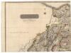
Northern Part of Aberdeen & Banff Shires.
Thomson, John, 1777- ca. 1840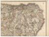
Northern Part of Aberdeen & Banff Shires.
Thomson, John, 1777- ca. 1840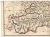
Southern Part of Aberdeen & Banff Shires.
Thomson, John, 1777- ca. 1840