Maps of Shetland Islands
A large draught of the ISLES of ORKNEY with the north part of SCOTLAND
from The sea-atlas : containing an hydrographical description of most of the sea-coasts of the known parts of the world.

A general map of Scotland and islands thereto belonging, 2
1 Blatt : 91 x 62 cm s.n.
Orcadum et Shetlandiae Insularum accuratissima descriptio.
Blaeu, Willem Janszoon, 1571-1638 Blaeu, Joan, 1596-1673
Chart of Shetland Isles and Orkney Islands
1 : 15000000 Columbine, Edward Henry
Orcadvm et Schetlandiæ insvlarvm accuratissima descriptio
2 Karten auf 1 Blatt : Kupferdruck ; zusammen 37 x 48 cm Valck; Schenk apud G. Valk et P. Schenk
Orcadvm et Schetlandiæ insvlarvm accuratissima descriptio
2 Karten auf 1 Blatt : Kupferdruck ; zusammen 39 x 52 cm Blaeu; Blaeu Joan Blaeu
[Orkney Islands, Shetland Islands.]
Great Britain. Hydrographic Office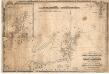
A chart of the north coast of Scotland including the Orkney and Shetland Islands.
Blachford, W.
Orcadum et Schetlandiae Insularum accuratissima descriptio. [Karte, Orcades], in: Gerardi Mercatoris et I. Hondii Newer Atlas, oder, Grosses Weltbuch, Bd. 1, S. 69.
1 Karte aus Atlas Mercator, Gerhard und Hondius, Jodocus Jansson, Jan
Nieuwe paskaart van de Orcades Eylanden / door Vooght geometra.
Vooght, Claes Janszoon, d. 1696. Keulen, Johannes van, 1654-1715.
Orcadum et Schetlandiae Insularum accuratissima descriptio. [Karte, Orcades], in: Novus atlas absolutissimus, Bd. 8, S. 180.
1 Karte aus Atlas Janssonius Offizin
Scotland / J. Ainslie, 3
1 Blatt : 67 x 58 cm Ainslie, Faden
Museumskart 149: Kaart over de Hetlandske Øer
1 : 100000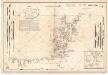
Carte des Isles Orcades.
Depot Generale de la Marine, Paris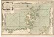
A new chart of the north coast of Scotland with... the Orkney Islands.
Bennett, J. Sayer, R.
Ordnance Survey of Great Britain, Scotland
Ordnance Survey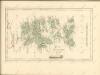

Ordnance Survey of Great Britain, Scotland
Ordnance Survey
Shetland Islands.
1 : 197000 Thomson, John
Shetland Islands.
Thomson, John, 1777- ca. 1840 Johnson, William, fl. 1806-1840
The Islands of Shetland / by H. Moll.
Moll, Herman, d. 1732
The Shetland Isles.
Great Britain. Hydrographic Office
A chart of the islands of Orkney... with the coast of Scotland.
Eunson, George
ORCADVM et SCHETLANDIÆ | INSVLARVM accuratissima descriptio.
[Amsterdam : Joan Blaeu]
Het Eyland Hitland met Zyn onderhoorige Eylanden : Wort by de Engelsche Shetland genaamt / by Gerard van Keulen.
Keulen, Gerard van
Carte des Isles Shetland.
Depot Generale de la Marine, Paris
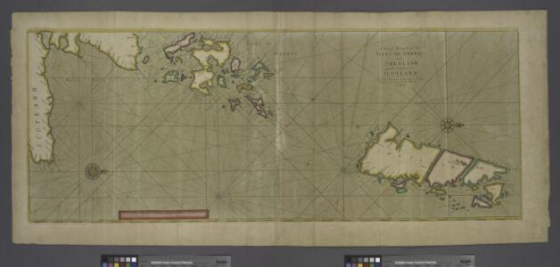
A new hydrographical survey of the islands of Shetland.
Preston, Thomas, fl. 1743-1744
A chart of the Orkney Islands.
Aberdeen, William, fl. ca. 1742-1794