Maps of Moray

Nieuwe pascaert van de Oost cust van Schotlandt : beginnende van Barwyck tot aen de Orcades Ylanden
1 : 700000 Annotatie: Uit (krt. 24): Nieuwe groote lichtende zee-fakkel ... - Amsterdam : Gerard Hulst van Keulen, 1782 Amsterdam : Iohannes van Ceulen
The East Coast of Scotland with the Isles of Orkney and Shetland.
Collins, Greenvile, fl. 1669-1698
L'Ecosse divisee en Shires ou Comtes.
1 : 960000 Robert de Vaugondy, Gilles, 1688-1766
Scotland NE.
1 : 500000 Cary, John, ca. 1754-1835
De Custen van Schotlandt van Donde tot d'Eijlanden van Orcanesse. De kusten van Schotlandt van Donde tot Eijlanden Orcanesse.
Blaeu, Willem Janszoon, 1571-1638
Carte particuliere de la cote orientale d'Ecosse, depuis St Abb's Head jusqu'a Duncansby Head.
Depot Generale de la Marine, Paris
Nieuwe Pascaert van de oost cust van Schotlandt beginnende van Barwyck tot aen de Orcades Ylanden ... / by Johannes van Ceuylen.
Keulen, Johannes van, 1654-1715
Scotland NE.
1 : 486830 Stanford, Edward
Scotiae Provinciae intra Flumen Taum, et Murrafyrth sitae, utpote Moravia, Badenocha, Atholia, Aberdonia, Baneia et Mernis. [Karte], in: Novus atlas absolutissimus, Bd. 8, S. 163.
1 Karte aus Atlas Janssonius Offizin
Scotiæ tabula
1 Karte : Kupferdruck ; 18 x 27 cm Quad; Nagel Johannes Bussemacher
A general map of Scotland and islands thereto belonging, 2
1 Blatt : 91 x 62 cm s.n.
Scotland II.
1 : 765000 Society for the Diffusion of Useful Knowledge (Great Britain)
Scotland / J. Ainslie, 6
1 Blatt : 67 x 58 cm Ainslie, Faden
Scotiæ provinciæ intra flumen Taum, et Murra fyrth sitæ
1 Karte : Kupferdruck ; 42 x 51 cm Valck; Schenk Gerard Valck et Pieter Schenk
Scotland / J. Ainslie, 3
1 Blatt : 67 x 58 cm Ainslie, Faden
Ordnance Survey of Great Britain, Scotland
Ordnance Survey
Beschrijvinge van een deel vann Schottlandt van Bambourg tot Aberdein : daer Edenburg de princepaele Coepstat in is, So hem tlant daer 'bthoont, beneffens 2 eÿlende / door Lucas Ianss Wagenaer ; Ioann
Waghenaer, Lucas Janszoon, 1534 or 5-1606
Carte des environs d'Edenburg
1 Karte : Kupferdruck ; 45 x 57 cm Robert de Vaugondy; Arrivet; Fortin; Dussy; Dorret chez le Sr. Fortin ing.r mécanicien du roy rue de la harpe près la rue du Foin
DVO VICECOMITATVS | ABERDONIA & BANFIA, | Una cum Regionibus & terrarum tractibus | sub iis comprehensis. [=] A Description of the two Shyres | ABERDENE and BANF, | With such Countreys and Provinces as ar | comprehended under them.
Auctore Roberto Gordonio à Straloch. [Amsterdam : Joan Blaeu]
A chart of part of the North of Scotland, from Banff to Duncansby Head.
Ainslie, John, 1745-1828
A chart of part of the North of Scotland, from Banff to Duncansby Head.
Ainslie, John, 1745-1828
A chart of part of the North of Scotland, from Banff to Duncansby Head.
Ainslie, John, 1745-1828
A chart of part of the North of Scotland, from Banff to Duncansby Head.
Ainslie, John, 1745-1828
A chart of part of the South of Scotland, from Berwick upon Tweed to Skateraw Harbour in the County of Kincardine...
Ainslie, John, 1745-1828
A chart of part of the South of Scotland, from Berwick upon Tweed to Skateraw Harbour in the County of Kincardine...
Ainslie, John, 1745-1828
A chart of part of the South of Scotland, from Berwick upon Tweed to Skateraw Harbour in the County of Kincardine...
Ainslie, John, 1745-1828
A chart of part of the South of Scotland, from Berwick upon Tweed to Skateraw Harbour in the County of Kincardine...
Ainslie, John, 1745-1828
Nordsee
1 : 150000 Severní moře Reichs-Marine-Amt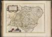
Duo Vicecomitatus Aberdonia & Banfia, una cum Regionibus & terrarum tractibus sub iis comprehensis / Auctore Roberto Gordonio à Straloch. Description of the two Shyres Aberdene and Banf,
Gordon, Robert, 1580-1661 Blaeu, Joan, 1596-1673


