Maps of Moray
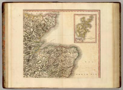
Scotland NE.
1 : 500000 Cary, John, ca. 1754-1835
Scotland NE.
1 : 486830 Stanford, Edward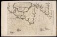
De Custen van Schotlandt van Donde tot d'Eijlanden van Orcanesse. De kusten van Schotlandt van Donde tot Eijlanden Orcanesse.
Blaeu, Willem Janszoon, 1571-1638
A general map of Scotland and islands thereto belonging, 2
1 Blatt : 91 x 62 cm s.n.
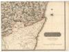
Carte particuliere de la cote orientale d'Ecosse, depuis St Abb's Head jusqu'a Duncansby Head.
Depot Generale de la Marine, Paris
Nieuwe Pascaert van de oost cust van Schotlandt beginnende van Barwyck tot aen de Orcades Ylanden ... / by Johannes van Ceuylen.
Keulen, Johannes van, 1654-1715
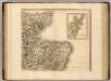
Scotland / J. Ainslie, 3
1 Blatt : 67 x 58 cm Ainslie, Faden
Scotland 2.
1 : 760320 Letts, Son & Co.
Scotiae Provinciae intra Flumen Taum, et Murrafyrth sitae, utpote Moravia, Badenocha, Atholia, Aberdonia, Baneia et Mernis. [Karte], in: Novus atlas absolutissimus, Bd. 8, S. 163.
1 Karte aus Atlas Janssonius Offizin
Scotiæ provinciæ intra flumen Taum, et Murra fyrth sitæ
1 Karte : Kupferdruck ; 42 x 51 cm Valck; Schenk Gerard Valck et Pieter Schenk
Ordnance Survey of Great Britain, Scotland
Ordnance Survey
EXTIMA SCOTIÆ | SEPTENTRIONALIS ORA, | ubi Provinciæ sunt | ROSSIA, SVTHERLANDIA, CATHENESIA, | STRATH-NAVERNIÆ, | cum vicinis regiunculis quæ eis subsunt, etiamque | MORAVIA.
R. Gordonius à Strath-loch collegit et descripsit. [Amsterdam : Joan Blaeu]
Scotland[Motoring Map of]
London : "Geographia
Extimae Scotiae pars Septentrionalis, in qua Provinciae Rossia, Sutherlandia, Cathenesia, et Strath-Naverniae. [Karte], in: Novus atlas absolutissimus, Bd. 8, S. 166.
1 Karte aus Atlas Janssonius Offizin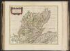
Extima Scotiae septentrionalis ora, ubi Provinciae sunt Rossia, Sutherlandia, Cathenesia, Strath-Naverniae, cum vicinis regiunculis quae eis subsunt, etiamque Moravia / R. Gordonius à Strath-loch coll
Gordon, Robert, 1580-1661 Blaeu, Joan, 1596-1673
DVO VICECOMITATVS | ABERDONIA & BANFIA, | Una cum Regionibus & terrarum tractibus | sub iis comprehensis. [=] A Description of the two Shyres | ABERDENE and BANF, | With such Countreys and Provinces as ar | comprehended under them.
Auctore Roberto Gordonio à Straloch. [Amsterdam : Joan Blaeu]
A chart of part of the North of Scotland, from Banff to Duncansby Head.
Ainslie, John, 1745-1828
A chart of part of the North of Scotland, from Banff to Duncansby Head.
Ainslie, John, 1745-1828
A chart of part of the North of Scotland, from Banff to Duncansby Head.
Ainslie, John, 1745-1828
A chart of part of the North of Scotland, from Banff to Duncansby Head.
Ainslie, John, 1745-1828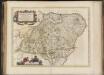
Duo Vicecomitatus Aberdonia & Banfia, una cum Regionibus & terrarum tractibus sub iis comprehensis / Auctore Roberto Gordonio à Straloch. Description of the two Shyres Aberdene and Banf,
Gordon, Robert, 1580-1661 Blaeu, Joan, 1596-1673
Dvo vicecomitatvs Aberdonia [et] Banfia
1 Karte : Kupferdruck ; 41 x 54 cm Blaeu; Gordon Joan Blaeu
Topographical and military map of the counties of Aberdeen, Banff and Kincardine.
Robertson, James, fl. 1810-1829
Topographical and military map of the counties of Aberdeen, Banff and Kincardine.
Robertson, James, fl. 1810-1829
Topographical and military map of the counties of Aberdeen, Banff and Kincardine.
Robertson, James, fl. 1810-1829
Topographical and military map of the counties of Aberdeen, Banff and Kincardine.
Robertson, James, fl. 1810-1829
Topographical and military map of the counties of Aberdeen, Banff and Kincardine.
Robertson, James, fl. 1810-1829
Topographical and military map of the counties of Aberdeen, Banff and Kincardine.
Robertson, James, fl. 1810-1829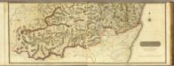
Composite: South Aberdeen, Banff S.
1 : 95000 Thomson, John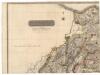
Northern Part of Aberdeen & Banff Shires.
Thomson, John, 1777- ca. 1840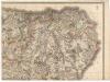
Northern Part of Aberdeen & Banff Shires.
Thomson, John, 1777- ca. 1840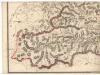
Southern Part of Aberdeen & Banff Shires.
Thomson, John, 1777- ca. 1840