Maps of Westminster
Surrey III.NW - OS Six-Inch Map
1 : 10560 Topographic maps Ordnance Survey Ordnance Survey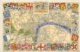
The Royal Wedding picture map of the road
A POCKET MAP of the Cities of LONDON, WESTMINSTER & SOUTHWARK With the Addition of the Buildings to the Present Year
The title of this pocket map of London, Westminster and Southwark appears in cartouche at bottom centre alongside the city arms. A compass star is depicted in the river with a publisher’s imprint (in scroll) at bottom left. An engraver by trade, Thomas Bowles acquired the stock of cartographers Morden & Lea at the beginning of the 18th Century, starting a successful publishing house, the output of which was almost entirely derivative. Bowles' brother, John, was also a print seller and publisher. Their businesses were separate, but the two often worked together. Bowles, Thomas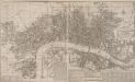
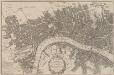
A New and Exact PLAN of the CITIES OF LONDON & WESTMINSTER and the Borough of SOUTHWARK. With all y.e Additional New Buildings to y.e Present Year 1724
The title of this map of London appears in cartouche at middle right, with compass rose at top right, and a key to buildings at bottom right. A historical note appears at bottom centre along with a scale bar, the fares of hackney coaches and water ferries, and illustrations of oars and sculls. This map is divided into squares with numbers along borders for reference. Smith, John
London, Westminster and Southwark
1 : 10138 This untitled map of Stuart London features royal arms at top left, city arms at top right, with a scale bar and dividers shown beneath a female figure with a globe at lower left. A key to Southwark's churches is provided at lower right. This map is derivative of Wenceslaus Hollar posthumously published plan of 1685 and features vignettes of prominent buildings along the top, together with portraits of King William and Queen Mary. At the foot of the plate, views of the seven city gates and the Tower of London accompany equestrian statues of Charles I and Charles II.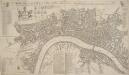
A NEW Mapp of the CITY of LONDON &c. With the Many additional Buildings and New Streets Anno 1720 In a Playne Method for Easy finding any street at first View
This is a later edition of a map first published in 1716. The title appears along the top, with a key to churches at top left, alongside coats of arms representing the City and the twelve Great Livery Companies. The key to individual city wards appears at top right. At bottom left are a compass rose, scale bar and the key to public buildings. Rates of hackney coaches and water ferries appear in a table at bottom centre. The map is similar to Overton’s map of 1706, showing St. Paul's and other prominent buildings pictorially. Taylor, Thomas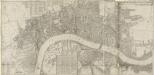
LONDON, WESTMINSTER & SOUTHWARK
This map of London was printed in six sections. The title appears in ribbon at top right, with a compass in the river at lower left, facing a key to company halls in a table at top left. City wards and parishes are shown in a table at bottom centre, with the streets of Westminster in a table at bottom left. Morden, Robert & Lea, Philip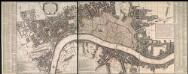
A New and Exact Plan of Ye City of London and suburbs thereof, 1731 93
This is the third edition of Overton's map of London and the suburbs first issued in 1720. The map features title in cartouche at top left, lists of Hackney coaches and watermen's rates at bottom left and centre, City arms at bottom right and compass in river. The area within the boundaries of the City of London is stippled, with ward boundaries highlighted in colour. The map is divided in squares with letters along the margins for reference. Overton, Henry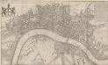
A New Mapp of the CITTY OF LONDON much Inlarged since the great Fire in 1666
This title of this map of Stuart London appears along the top, with the City arms depicted at top left, and a reference panel at top right. A scale bar with dividers features at bottom left, with the key to individual churches in Southwark in a banner at bottom right. Like many other contemporary plans of London, this one is derivative of Hollar's posthumously published map of1685. Overton, John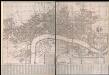
A New and Exact Plan of Ye City of London and Westminster, the Borough of Southwark, 1735
This map of London is probably based on an earlier map by William Morgan dating 1681-82. It features title in cartouche near bottom centre, rates of coaches and ferries to the right of the title and explanatory note to the left. The map is divided in squares with margins lettered for reference and key in columns at the foot of the plate. Westminster Bridge and other prominent buildings represented pictorially. Jeffreys, Thomas
FORD'S ILLUSTRATED MEMORIAL OF THE GRAND INDUSTRIAL EXHIBITION OF ALL NATIONS, HYDE PARK, LONDON 1851
This pictorial map commemorates the Great Exhibition of 1851, conceived by Henry Cole and presided over by Prince Albert. Theexhibition was held in the Crystal Palace. Designed by Joseph Paxton, it showcased exhibits from all over the world, including the largest pearl ever found, a knife with 300 blades, and the Koh-i-Noor diamond. The exhibition was opened by Queen Victoria in May 1851. She remained a frequent visitor, as did the Duke of Wellington. Only main roads in the capital are shown on this map and London locations are marked by small medallions containing scenes. Borders of roundels contain people from "all nations". Queen Victoria and Albert flank a view of the Crystal Palace, which was removed from Hyde Park in 1852andrebuilt at Sydenham. Simpson Ford, William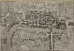
LONDRA
This small Italian etching is one of the earliest surviving maps of the city of London. It appeared in a book by Francesco Velagio entitled 'Raccolta di le piu` illustri et famose citta di tutto il mondo'. Published in Venice around 1595, the book depicts the main Italian and European cities. The map was copied for a fresco in a church in the Italian city of Mantua. Velagio, Francesco
A Plan of London, Westminst.r and Southwark
This is derivative of Hatton's edition of Braun & Hogenberg's map-view of London. Unusually for a map of its time, most of the buildings are represented in plan instead of pictorially. The Latin text at the foot of the plate in the original are replaced by notes, in English, on the geographic and demographic growth of the city. Braun, Georg & Hogenberg, Frans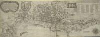
The Newest and Exactest MAPP of the most Famous Citties LONDON and WESTMINSTER, with their Suburbs; and the manner of their Streets:
The arms of the Commonwealth and of the City appear on the upper-left cornermap, facing the personifications of Justice and Prudence on the upper right. A number key is provided so users can find "the nearest way from one place to another." 'Pecadilly Hall' appears in place of modern Piccadilly. This was a derisive name for the country house built around1612 by Robert Baker, a tailor with a shop on the Strand. Baker made his fortune by selling "picadils" (a stiff collar popular at Court). By the 18th Century, Piccadilly was the name of the whole street. Porter, T.
Plan of London, West.r and Southwark, w.th y.e Riv.r Thames, as they were survey.d and publisht by Authority toward y.e latter end of y.e reign of Queen Elizaabeth, or about y.e year of our Lord 1600.
This is the fourth edition of Braun &Hogenberg's map view of London. The title in cartouche at the foot of the plate replaces the figures of merchants from the earlier editions. Tudor arms feature at top right, with the city arms at top left and descriptive notes at bottom right and bottom left. Published in Hatton's 'A New View of London; or, an Ample Account of that City', the map is similar in detail to the 'Copperplate Map', the earliest printed map of London of which no complete copy survives. Merchant ships, cranes, mills, bull- and bear-baiting pits, the large tennis courts at Westminster and the stags in St. James’s are examples of London's business and leisure activities. Walled gardens, elegant churches and livery halls testify to the high quality of life enjoyed by its citizens. Braun, Georg & Hogenberg, Frans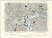
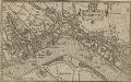
London VII.SW - OS Six-Inch Map
1 : 10560 Topographic maps Ordnance Survey Ordnance Survey
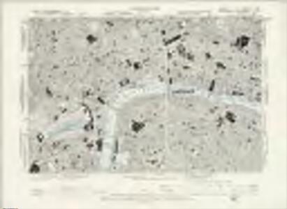
Ordnance Survey of London Skeleto
Ordnance Survey
LONDON FERACISSIMI ANGLIAE REGNI METROPOLIS
The title of this map of London appears at the top of the plate, flanked by Tudor and city arms. A note on the history of London features at bottom left and on the Steelyard at bottom right. Illustrated figures of merchants appear at bottom centre. Published in 'Civitates Orbis Terrarum', the map is similar in detail to the 'Copperplate Map', the earliest printed map of London of which no complete copy survives. Merchant ships, cranes, mills, bull and bear baiting pits, the large tennis courts at Westminster and the stags in St. James’s are examples of London business and leisure activities. Walled gardens, elegant churches and livery halls testify to the high quality of life enjoyed by its citizens. Braun, Georg & Hogenberg, Frans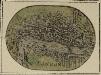
LONDON 20
A miniature map of London and Westminster with title at the foot of the plate and areas outside the built-up area coloured green.
LONDON and WESTMINSTER in the Reign of QUEEN ELIZABETH, Anno Dom. 1563 25
This retrospective map of Elizabethan London was produced in the 1820s. It provides us with an idea of how people in the19th century viewed the Elizabethan city. The location of Tower Bridge is indicated on this map, even though plans for the actual bridge were not made until 1879. Neele, George
Vrbium Londini et West-Monasterii nec non suburbii Southwark accurata ichnographia, 1
1 Blatt : 52 x 64 cm Homännische Erben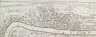
LONDON and WESTMINSTER in the Reign of QUEEN ELIZABETH Anno Dom. 1563
This is a retrospective map of Elizabethan London, giving us an idea of how people in the late 18th Century viewed the Elizabethan capital. The present-day Covent Garden is an area of fields named "Convent Garden”, indicating that the area belonged to the Abbey of St Peter's at Westminster before the dissolution of monasteries in the reign of Henry VIII. The location of Tower Bridge is marked, although the actual bridge was not planned until 1879. This indicates that Londoners were thinking about bridging the river at this point one hundred years before the decisive plan to do so. Wallis, J.
A new and exact plan of the city of London and suburbs thereof, 2
1 Blatt : 60 x 51 cm Henry Overton
A Copy of Part of a Map of London from Newcourt
This is a copy of part of the Faithorne map. It is an example of a bird's-eye (or 'plan') view. Crace often had copies made of maps if he was unable to procure an original.
LONDINIUM Augusta
1 : 11019 The title of this engraved map of Roman London appears along the top, with compass rose at top right.The arms of the Count of Pembroke, to whom the map is dedicated, are depicted at bottom right. Published in 'Itinerarium Curiosum' by William Stukeley, an antiquarian with a scholarly interest in sacred history, the plan shows the Roman street plan and road network, with illustrated views of the city wall and other prominent architectural and geographical features. Stukeley, Dr. William
A New and Exact Plan of the City of LONDON and Suburbs thereof, With the addition of the New Buildings, Churches &c. to this present Year 1720 (Not extant in any other)
1 : 6336 This map of the West End of London is part of Henry Overton's complete map of London and its suburbs, published in 1720.The title and publisher's imprint appear in cartouche in the centre, with fares of hackney coaches and an overall key at bottom left. The compass rose appears in the river, with parish boundaries outlined in colour. Henry Overton took over his father John's publishing business in 1707 and continued to publish maps from the same address at White Horse near Newgate. Overton, Henry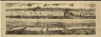
Views of London in 1616 and 1890
1 : 1
The City of LONDON in the Time of the Saxons (about the Year 1000) compiled from the most authentic DOCUMENTS
Map of London in the reign of the Saxon King Ethelred II, with the history of Roman and Saxon London written in a panel below the plan. The map shows the Roman wall still standing, but the street plan suggests that, compared to the Roman period, the built-up area occupied a much smaller part of the walled city and that the population was in rapid decline. Wallis
LABYRINTHUS LONDINENSIS or THE EQUESTRIAN PERPLEXED
The author of this small plan of London invites his readers to find their way around the city, from the Strand to St. Paul's, avoiding the many roads closed for repair. The plan's title appears at the top, with the royal Arms at the top left, the city arms at the top right, the arms of Bridge House at the bottom right and the arms of Westminster at the bottom left. A note explains the rules of the puzzle in the panel below the plan. Ingrey, Charles