Maps of Westminster

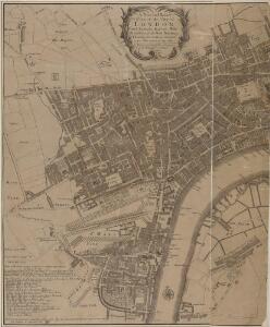
A New and Exact Plan of the City of LONDON and Suburbs thereof, With the addition of the New Buildings, Churches &c. to this present Year 1720 (Not extant in any other)
1 : 6336 This map of the West End of London is part of Henry Overton's complete map of London and its suburbs, published in 1720.The title and publisher's imprint appear in cartouche in the centre, with fares of hackney coaches and an overall key at bottom left. The compass rose appears in the river, with parish boundaries outlined in colour. Henry Overton took over his father John's publishing business in 1707 and continued to publish maps from the same address at White Horse near Newgate. Overton, Henry
A new and exact plan of the city of London and suburbs thereof, 1
1 Blatt : 60 x 52 cm Henry Overton
NEW and ACCURATE PLAN of the CITY of WESTMINSTER, The DUTCHY of LANCASTER and Places Adjacent
1 : 11520 The title of this map appears in cartouche at top right, with a compass rose at top left. A territory with its own courts and administration, the Duchy of Lancaster was created in 1267 by Edward III for his younger son John. The Duchy was attached to the Crown when Prince Henry of Bolingbroke, the last Duke of Lancaster, became Henry IV in 1399. To this day, the Duchy has retained its own jurisdiction under the Chancellor of the Duchy of Lancaster.The chancellorship is a high governmental position, and sometimes a cabinet poist. Since, for at least the last two centuries, the Chancellor rarely has had any significant duties pertaining to the Duchy's management, he is usually available as a minister without portfolio. Recent Chancellors have included Labour cabinet minister Mo Mowlam.
Vrbium Londini et West-Monasterii nec non suburbii Southwark accurata ichnographia, 1
1 Blatt : 52 x 64 cm Homännische Erben
A NEW and ACCURATE PLAN of the CITY of WESTMINSTER The DUTCHY of LANCASTER and Places Adjacent
John Rocque developed his surveying talent at a young age, making plans of the great houses and gardens of the nobility.This early experience led to him taking up large-scale surveying, producing plans such as this one of Westminster. Here, Tottenham Court and Marylebone are mostly fields but Westminster has grown sufficiently to demand the construction of a new bridge.Westminster Bridge was opened in 1750 and watermen were paid 163;25,000 in compensation as the new bridge made them largely redundant. The Chelsea Water Works Company, shown south of Totthill Fields, was set up to improve water supply to Westminster and "parts adjacent".The Company were the first to introduce slow sand filtration to purify Thames water. Rocque, John
Ordnance Survey of London Skeleto
Ordnance Survey
London VII.SW - OS Six-Inch Map
1 : 10560 Topographic maps Ordnance Survey Ordnance Survey
FORD'S ILLUSTRATED MEMORIAL OF THE GRAND INDUSTRIAL EXHIBITION OF ALL NATIONS, HYDE PARK, LONDON 1851
This pictorial map commemorates the Great Exhibition of 1851, conceived by Henry Cole and presided over by Prince Albert. Theexhibition was held in the Crystal Palace. Designed by Joseph Paxton, it showcased exhibits from all over the world, including the largest pearl ever found, a knife with 300 blades, and the Koh-i-Noor diamond. The exhibition was opened by Queen Victoria in May 1851. She remained a frequent visitor, as did the Duke of Wellington. Only main roads in the capital are shown on this map and London locations are marked by small medallions containing scenes. Borders of roundels contain people from "all nations". Queen Victoria and Albert flank a view of the Crystal Palace, which was removed from Hyde Park in 1852andrebuilt at Sydenham. Simpson Ford, William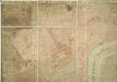
A PLAN OF HIS MAJESTY'S BAYLIWICK OF ST. JAMES IN THE COUNTY OF MIDDLESEX
1 : 2400 This drawn survey of the West of London extends from Knightsbridge to Temple Bar and from Marylebone Gardens to Buckingham Palace. Buildings are indicated in red, open spaces and park land in green and watercourses in blue. Symbols are used to distinguish land use. Gough, William
A Copy of Part of a Map of London from Newcourt
This is a copy of part of the Faithorne map. It is an example of a bird's-eye (or 'plan') view. Crace often had copies made of maps if he was unable to procure an original.
WESTMINSTER
This plan-view of Westminster was published in Norden's 'Speculum Britanniae' in 1593. The title appears at top right below the royal arms, with a compass rose at the foot of the plate. Under different jurisdiction than the City of London, Westminster had developed during the middle ages into a centre of royal administration. Along the Strand are the former residences of the Bishops deposed at the Reformation. By the late 16th Century, these properties were in the hands of the Queen's courtiers, statesmen and other people of influence. Norden, John
PLAN, presented to the House of Commons, of a STREET proposed from Charing Cross to Portland Place, leading to the Crown Estate in Mary-le-Bone Park
1 : 3684 This original design for Regent Street was commissioned by the House of Commons.The title appears along the top, with a descriptive note below the plan and a scale bar at the bottom centre. Crown Property is highlighted in blue.Starting at Carlton House, Regent Street ran through crownland at Piccadilly (where a circus was built) before turning north-west along Swallow Street, in Soho, finally joining Portland Place north of Oxford Street. Basire, James
PLAN OF A Street Proposed FROM CHARING CROSS TO PORTLAND PLACE.
1 : 6000 This is Nash's original design for Regent Street.The title appears at top right, with compass star and scale bar at the bottom left. The course of the street highlighted in yellow, with Crown property is highlighted in blue.Starting at Carlton House, Regent Street ran through crownland at Piccadilly (where a circus was built) before turning north-west along Swallow Street, in Soho, finally joining Portland Place north of Oxford Street. Thompson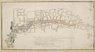
Plan, presented to the House of Commons, of a street proposed from Charing Cross to Portland Place, leading to the Crown Estate in Mary-le-Bone Park.
Basire, James
Insurance Plan of London Vol. VIII: Key Plan
1 : 480 This "key plan" indicates coverage of the Goad 1888 series of fire insurance maps of London that were originally produced to aid insurance companies in assessing fire risks. The building footprints, their use (commercial, residential, educational, etc.), the number of floors and the height of the building, as well as construction materials (and thus risk of burning) and special fire hazards (chemicals, kilns, ovens) were documented in order to estimate premiums. Names of individual businesses, property lines, and addresses were also often recorded. Together these maps provide a rich historical shapshot of the commercial activity and urban landscape of towns and cities at the time. The British Library holds a comprehensive collection of fire insurance plans produced by the London-based firm Charles E. Goad Ltd. dating back to 1885. These plans were made for most important towns and cities of the British Isles at the scales of 1:480 (1 inch to 40 feet), as well as many foreign towns at 1:600 (1 inch to 50 feet). Chas E Goad Limited Chas E Goad Limited
Insurance Plan of London Vol. IX: Key Plan
1 : 480 This "key plan" indicates coverage of the Goad 1889 series of fire insurance maps of London that were originally produced to aid insurance companies in assessing fire risks. The building footprints, their use (commercial, residential, educational, etc.), the number of floors and the height of the building, as well as construction materials (and thus risk of burning) and special fire hazards (chemicals, kilns, ovens) were documented in order to estimate premiums. Names of individual businesses, property lines, and addresses were also often recorded. Together these maps provide a rich historical shapshot of the commercial activity and urban landscape of towns and cities at the time. The British Library holds a comprehensive collection of fire insurance plans produced by the London-based firm Charles E. Goad Ltd. dating back to 1885. These plans were made for most important towns and cities of the British Isles at the scales of 1:480 (1 inch to 40 feet), as well as many foreign towns at 1:600 (1 inch to 50 feet). Chas E Goad Limited Chas E Goad Limited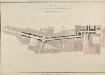
PLAN OF A NEW STREET FROM CHARING CROSS TO PORTLAND PLACE
The lack of street planning in the West End had been lamented by the architect John Gwynn in 1766 and he had suggested a plan along similar lines to the one shown here. In 1811 Portland Place would revert to the Crown, and without a new road to decrease travelling time to the city centre, profitable development of the land was unlikely. Basire, James
Insurance Plan of London: General Key Plan of North Side of River
1 : 4800 This "key plan" indicates coverage of the Goad 1889 series of fire insurance maps of London that were originally produced to aid insurance companies in assessing fire risks. The building footprints, their use (commercial, residential, educational, etc.), the number of floors and the height of the building, as well as construction materials (and thus risk of burning) and special fire hazards (chemicals, kilns, ovens) were documented in order to estimate premiums. Names of individual businesses, property lines, and addresses were also often recorded. Together these maps provide a rich historical shapshot of the commercial activity and urban landscape of towns and cities at the time. The British Library holds a comprehensive collection of fire insurance plans produced by the London-based firm Charles E. Goad Ltd. dating back to 1885. These plans were made for most important towns and cities of the British Isles at the scales of 1:480 (1 inch to 40 feet), as well as many foreign towns at 1:600 (1 inch to 50 feet). Chas E Goad Limited Chas E Goad Limited
Insurance Plan of London: General Key Plan
1 : 4800 This "key plan" indicates coverage of the Goad 1889 series of fire insurance maps of London that were originally produced to aid insurance companies in assessing fire risks. The building footprints, their use (commercial, residential, educational, etc.), the number of floors and the height of the building, as well as construction materials (and thus risk of burning) and special fire hazards (chemicals, kilns, ovens) were documented in order to estimate premiums. Names of individual businesses, property lines, and addresses were also often recorded. Together these maps provide a rich historical shapshot of the commercial activity and urban landscape of towns and cities at the time. The British Library holds a comprehensive collection of fire insurance plans produced by the London-based firm Charles E. Goad Ltd. dating back to 1885. These plans were made for most important towns and cities of the British Isles at the scales of 1:480 (1 inch to 40 feet), as well as many foreign towns at 1:600 (1 inch to 50 feet). Chas E Goad Limited Chas E Goad Limited
Plan of the Road through Westminster and Tutthill Fields & from St. James's Park Gate by Buckingham House & from Hyde Park Corner to a Bridge that is desired to be made over the Thames 1768 27
This engraved plan shows the road through Tutthill Fields in Westminster leading to the new bridge at Vauxhall.The plan's title features in banner at top left, with compass star at bottom right.The proposed new road stippled and highlighted in colour.
London (1915- Numbered sheets) V.13 (includes: City Of Westminster) - 25 Inch Map
1 : 2500 Topographic maps Ordnance Survey Ordnance Survey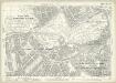
London (Edition of 1894-96) LXXV (includes: City Of Westminster) - 25 Inch Map
1 : 2500 Topographic maps Ordnance Survey Ordnance Survey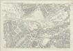
London (First Editions c1850s) XLIII (includes: City Of Westminster) - 25 Inch Map
1 : 2500 Topographic maps Ordnance Survey Ordnance Survey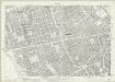
London (1915- Numbered sheets) V.9 (includes: City Of Westminster; St Marylebone; St Pancras) - 25 Inch Map
1 : 2500 Topographic maps Ordnance Survey Ordnance Survey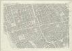
London (First Editions c1850s) XXXIV (includes: City Of Westminster; St Marylebone; St Pancras) - 25 Inch Map
1 : 2500 Topographic maps Ordnance Survey Ordnance Survey
A SURVEY OF THE CONDUITS &c. to WHITEHALL, St.JAMES &c.
1 : 3600 This is a 19th century copy of an original 1718 plan held by the Society of Antiquaries. t details the conduits supplying water to St. James's and Whitehall from Hyde Park. Long
ST. GEORGE'S PARISH, HANOVER SQUARE.
1 : 8448 This plan of the Parish of St George is surrounded by views of St George's church, Knightsbridge chapel, Conduit Street chapel, Chelsea chapel, Audley Street chapel and Berkeley chapel, the whole set within a decorative border. The title and imprint appear at the foot of the plate. The Parish of St George was created in 1725 and covered an area previously in the Parish of St. Martin-in-the-Fields that stretched from Regent Street (then called Swallow Street) to the Serpentine, and from Oxford Street to Mayfair, Belgravia and Pimlico. Bickham, J.
Drawn plan of the Goring Estate] 3
This is a copy by Crace of a plam of the Goring Estate as it was in 1640. The drawing shows the site in Mulberry Garden Fields where Buckingham Palace was built. Crace, Frederick
Collins' Illustrated Atlas of London with 7000 references, in 36 plates of the principal routes between St. Paul's and the suburbs, from a survey made expressly for this work, by R. Jarman