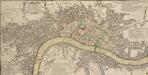
Maps of Islington

Plan of London, West.r and Southwark, w.th y.e Riv.r Thames, as they were survey.d and publisht by Authority toward y.e latter end of y.e reign of Queen Elizaabeth, or about y.e year of our Lord 1600.
This is the fourth edition of Braun &Hogenberg's map view of London. The title in cartouche at the foot of the plate replaces the figures of merchants from the earlier editions. Tudor arms feature at top right, with the city arms at top left and descriptive notes at bottom right and bottom left. Published in Hatton's 'A New View of London; or, an Ample Account of that City', the map is similar in detail to the 'Copperplate Map', the earliest printed map of London of which no complete copy survives. Merchant ships, cranes, mills, bull- and bear-baiting pits, the large tennis courts at Westminster and the stags in St. James’s are examples of London's business and leisure activities. Walled gardens, elegant churches and livery halls testify to the high quality of life enjoyed by its citizens. Braun, Georg & Hogenberg, Frans
A Plan of London, Westminst.r and Southwark
This is derivative of Hatton's edition of Braun & Hogenberg's map-view of London. Unusually for a map of its time, most of the buildings are represented in plan instead of pictorially. The Latin text at the foot of the plate in the original are replaced by notes, in English, on the geographic and demographic growth of the city. Braun, Georg & Hogenberg, Frans
LONDINUM FERACISSIMI ANGLIAE REGNI METROPOLIS
This derivative of Braun & Hogenberg's 1572 map of London was published in Belle Forest's 'La Cosmographie universelle de tout le monde'. The map's title features at the top of the plate, flanked by Tudor and city arms. Descriptive notes in French appear at bottom left and bottom right, with figures of merchants at bottom centre. The map is similar in detail to the 'Copperplate Map', the earliest printed map of London of which no complete copy survives. Merchant ships, cranes, mills, bull- and bear-baiting pits, the large tennis courts at Westminster and the stags in St. James’s are examples of London business and leisure activities. Walled gardens, elegant churches and livery halls testify to the high quality of life enjoyed by its citizens. Braun, Georg & Hogenberg, Frans
Plan nouveau et correct des villes et fauxbourgs de Londres et Westminster et du bourg de Southwark
1 Plan : Kupferdruck ; 28 x 48 cm Le Rouge Georges Louis le Rouge
A pocket map of London, Westminster and Southwark
1 Plan : Kupferdruck ; 26 x 51 cm Hoole; Seale printed and sold by H. Overton and J. Hoole at the White Horse without Newgate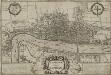
LONDINUM Vulgo LONDON
This later edition of Braun & Hogenberg's map of London and Westminster was published in Janssen's 'Illustrorem Principumque Urbium Septentrionalium Europae'. The map's title appears in a cartouche at the foot of the plate, replacing the figures of merchants of the first edition. Tudor arms feature top right, with city arms at top left and descriptive notes to the bottom right and bottom left. The map is similar in detail to the 'Copperplate Map', the earliest printed map of London of which no complete copy survives. Merchant ships, cranes, mills, bull and bear baiting pits, the large tennis courts at Westminster and the stags in St. James’s are examples of London's business and leisure activities. Walled gardens, elegant churches and livery halls testify to the high quality of life enjoyed by its citizens. Braun, Georg & Hogenberg, Frans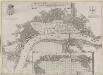
Grundstriss der Statt LONDON wie solche vor und nach dem Brand anzuschen sampt dem Newen Model wie selbige wid rum Auffgebauwet werden solle
This is a map of London immediately after the great fire of 1666. The map was first published by the Merian Heirs of Frankfurt in 1677, appearing in the anthology "Theatri Europei". The title appears in a scroll along the top, flanked by royal and city arms. Notes on shading and an inset plan of Robert Hooke’s designs for rebuilding the city appear in another scroll at the foot of the plate. Hooke's plan is given with its own key and reference table.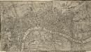
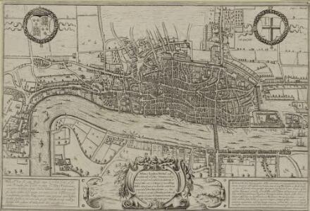
A Correct PLAN of the CITIES of LONDON & WESTMINSTER & BOROUGH of SOUTHWARK, including the BILLS of MORTALITY, with the ADDITIONAL BUILDINGS 118x
This map of London was published as a supplement to Vol. 30 of the 'London Magazine' in 1761. Attributed to John Rocque, the map’s title features in panel below the plan with the publisher’s imprint along the top. The Bills of Mortality referred to in the title were the areas in Greater London that reported death notices directly to the London government. Rocque, John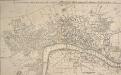
A New and Accurate PLAN of the CITIES of LONDON AND WESTMINSTER, including the NEW ROADS & NEW BUILDINGS. 1765
This map shows the London, Westminster and Blackfriars bridges across the Thames, marking the many stairways down to the water necessary before the bridges were built.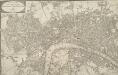
WALLIS'S PLAN of the CITIES of LONDON and WESTMINSTER 1797
This is the first edition of a map published seven times over a period of 16 years. This plan has been physically trimmed resulting in the loss of some information. The scale bar and list of Hackney coach fares would have been to the bottom right. Wallis, John
PLATTE GRONDT DER STADT LONDON MET NIEUW MODEL EN HOE DIE AFGEBRANDT IS
This later edition of the Frederick de Wit's 1666 plan features minor alterations to the title and some additions on the outskirts of the city. The map's title appears along the top, with the key to parish churches (in scrolls) at top left and top right and dividers at top right. An engraving depicting the city on fire is inset at bottom right. Below the plan, a description of the fire is reported in Dutch and French. This edition of the map shows cherubs holding the reference tables and a waterman with oars leaning against the view of the city. Wit, Frederick de
LONDON FERACISSIMI ANGLIAE REGNI METROPOLIS
The title of this map of London appears at the top of the plate, flanked by Tudor and city arms. A note on the history of London features at bottom left and on the Steelyard at bottom right. Illustrated figures of merchants appear at bottom centre. Published in 'Civitates Orbis Terrarum', the map is similar in detail to the 'Copperplate Map', the earliest printed map of London of which no complete copy survives. Merchant ships, cranes, mills, bull and bear baiting pits, the large tennis courts at Westminster and the stags in St. James’s are examples of London business and leisure activities. Walled gardens, elegant churches and livery halls testify to the high quality of life enjoyed by its citizens. Braun, Georg & Hogenberg, Frans
AUTHENTIC REMAINS AND PROBABLE SITE OF ROMAN LONDON FROM THE BEST AUTHORITIES
This engraved map of Roman London was based on archaeological discoveries of the first half of the 19th Century. The map's title and scale bar feature at bottom right, with keys to sites of archaeological discoveries (coins, urns and vases in the City of London and in Southwark) in reference tables at top right and bottom left.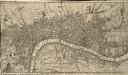
A Correct PLAN of the CITIES of LONDON & WESTMINSTER & BOROUGH of SOUTHWARK, including the BILLS of MORTALITY, with the ADDITIONAL BUILDINGS 118
This map of London was published as supplement to Volume 30 of the 'London Magazine' in 1761. Attributed to John Rocque, the map's title features in a panel below the plan, with the publisher’s imprint along the top. [Rocque, John]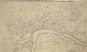
A New PLAN of LONDON WESTMINSTER and SOUTHWARK Engraved for Noorthouck's
This map highlights in red the boundaries of the old London Wall, built by the Romans. By the end of the 17th Century it had become an anachronistic nuisance. The first section (near Bishops Gate) was removed in 1707 and much of the rest was broken down or built over during the 18th Century. Most of the gates were pulled down in 1760/1, wtih Newgate, the last to survive, demolished in 1777. Noorthouck, John
LONDON 206
This plan for a survey of London was published in Volume VIII of ‘Encyclopaedia Londinensis' in 1814. The plan's title appears above the plan, with a compass star at the top right. St. Paul's Cathedral and other prominent buildings are shown pictorially, with other places of interest indicated by numbers. Jones, George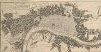
A MAP of LONDON, WESTMINSTER And SOUTHWARK With ye New Buildings to ye Year 1764
This pocket map of London was published in 'A New History of London' by the Reverend George Reeves. Its title appears in a square table near top left, with built-up areas in the city stippled while other built-up areas are hatched. St. Paul's Cathedral and other prominent buildings are represented pictorially. The map is a derivative of a 1740 map showing the housing development north of Cavendish Square, which was never built.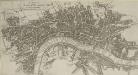
A MAP of LONDON, WESTMINSTER and SOUTHWARK. With ye New Buildings to ye Year 1733
This pocket map of London was published as the frontispiece to Volume I of "A Survey of the cities of London and Westminster, Borough of Southwark", by Robert Seymour. No new survey of the London area had been made between William Morgan's in 1682 and John Rocque's of 1746. The marked similarity of this map to the William Roades' 1731pocket map is testimony to this. The title of this drawing appears in a square tablet at top left, with prominent buildings shown pictorially. Robert Seymou (pseudonym of John Mottley)
PLATTE GRONDT DER STADT LONDON MET AENWYSINGHE HOE DIE AFGEBRANDT
This map was published in Amsterdam after the great fire of 1666. The title appears along the top of the manuscript, with the key to parish churches (in scrolls) at top left and top right, and dividers at top right. An engraving of the great fire is inset at bottom right, entitled "BRANDENT LONDON". Below the plan, the fire is described in Dutch and French. Wit, Frederick de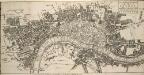
The ICHNOGRAPHY of the Cities of LONDON and WESTMINSTER and the Borough of SOUTHWARK 115x
This small map was published in 'The Natural History of England' by the scientist and instrument-maker Benjamin Martin. It comprised part of the complete 'General Magazine of Arts and Science' issued between 1756 and 1761. The map's title features in a square table at top right, and represents the built-up area within the city boundaries with stippling, and other built-up areas with crosshatching. "Ichnography" means ground-plan. Owen, William
PLAN of the CITY'S of LONDON, WESTMINSTER and Borough of SOUTHWARK; with the new Additional Buildings; Anno 1720
This map appeared in "A New General Atlas Containing a Geographical and Historical Account of the World", published by Daniel Browne et al. in 1721. Its title runs along the top, with dedication to Sir Peter Delme, Knight and Alderman, in cartouche at top left. The city arms and insignia, compass rose and scale bar feature at the foot of the plate. Reference tables to places in Westminster, London and Southwark appear in panels below the plan. Parker, S.
PLATTE GRONDT Der Verbrande Stadt LONDON
This map was published in Amsterdam aftermath the great fire of 1666. The title in a banner at top right, flanked by City and Royal arms. The design for rebuilding the City is inset in a panel at top left, with an engraved view of the fire in a banner at bottom centre. Below the plan is a description of the fire in Dutch, French and English with a key to streets and buildings. Doornick, Marcus Willemsz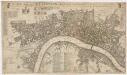
A new mapp of the city of London &c. : with the many additionall buildings and new streets anno 1723 in a playne
1 : 7300 Taylor, Thomas, fl. 1670-1730 Printed and sold by Thomas Taylor at the Golden Lyon in Fleet Street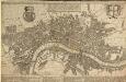
A POCKET MAP OF LONDON, WESTMINSTER AND SOUTHWARK With ye New Buildings to ye Year 1739
The map's title appears in English and Dutch in a panel along the top. A descriptive note features below the title, with royal arms at top left, city arms at top right and fares of hackney coaches and water ferries in a panel below the plan. The map shows the new bridge at Westminster and represents prominent buildings and landmark three-dimensionally. De Leth, Hendrick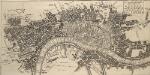
The ICHNOGRAPHY of the Cities of LONDON and WESTMINSTER and the Borough of SOUTHWARK 115
"Ichnography" means ground-plan. This small map was published in 'The Natural History of England' by the scientist and instrument-maker Benjamin Martin. This was part of the complete work 'General Magazine of Arts and Science' issued between 1756 and 1761. The map's title appears in a square table at top right. Built-up areas are stippled within the boundaries of the City of London, and crosshatched elsewhere. Owen, William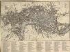
An IMPROVED PLAN of the CITIES of LONDON and WESTMINSTER and BOROUGH of SOUTHWARK, including the NEW BUILDINGS, ROADS &C. to the Present Year 1765.
The title of this pocket map appears along the top, with built-up areas represented by stippling in the City of London, and crosshatching elsewhere. A table of reference appears in a panel below the plan. The map, a later edition of Kitching and Parker's 1765 plan, shows the new bridge and the approaches at Blackfriars. Designed by Robert Mylne, this third bridge spanning the Thames was built between 1760 and 69. The nine semi-elliptical Portland stone arches were replaced from 1860 to 69 by the present structure of five wrought-iron arches each faced with cast iron, and a granite pier designed by Cubitt and Carr. Kitching, Thomas and Parker, Henry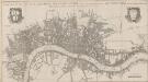
A NEW MAP OF THE CITYES OF LONDON, WESTMINSTER AND THE BURROUGH OF SOUTHWARK TOGETHER WITH THE SUBURBS AS THEY ARE NOW STANDDING Anno Dom.1707.
This title of this map of London appears along the top, with the city arms at top left and the publisher’s name in cartouche at top right. The map appeared in Volume I of 'A New View of London', by Edward Hutton. Chiswell, Richard et al.
A New Mapp of the CITTY OF LONDON much Inlarged since the great Fire in 1666
This title of this map of Stuart London appears along the top, with the City arms depicted at top left, and a reference panel at top right. A scale bar with dividers features at bottom left, with the key to individual churches in Southwark in a banner at bottom right. Like many other contemporary plans of London, this one is derivative of Hollar's posthumously published map of1685. Overton, John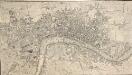
A NEW and Correct PLAN OF THE CITIES AND SUBURBS OF LONDON & WESTMINSTER & BOROUGH OF SOUTHWARK with the COUNTRY adjacent, the NEW BUILDINGS, ROADS &c. to the Year 1766
The title of this map runs along the top of the plan, which shows the new bridge at Blackfriars as "Pitt's Bridge". Designed by Robert Mylne, this third bridge spanning the Thames was built between 1760 and 69. The nine semi-elliptical Portland stone arches were replaced in a hundred years later by the present structure of five wrought-iron arches faced with cast-iron, and a granite pier designed by Cubitt and Carr. Gibson, John