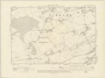
Maps of Herne and Broomfield
Kent XXXVI.NW - OS Six-Inch Map
1 : 10560 Topographic maps Ordnance Survey Ordnance Survey
Kent XXXVI.NW - OS Six-Inch Map
1 : 10560 Topographic maps Ordnance Survey Ordnance Survey
Kent XXXVI.NW - OS Six-Inch Map
1 : 10560 Topographic maps Ordnance Survey Ordnance Survey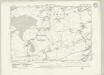
Kent XXXVI.NW - OS Six-Inch Map
1 : 10560 Topographic maps Ordnance Survey Ordnance Survey
Kent XXXVI.NW - OS Six-Inch Map
1 : 10560 Topographic maps Ordnance Survey Ordnance Survey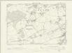
Kent XXXVI.NW - OS Six-Inch Map
1 : 10560 Topographic maps Ordnance Survey Ordnance Survey
Kent XXXVI.6 (includes: Chislet; Hoath; Westbere) - 25 Inch Map
1 : 2500 Topographic maps Ordnance Survey Ordnance Survey
Kent XXXVI.6 (includes: Chislet; Hoath; Westbere) - 25 Inch Map
1 : 2500 Topographic maps Ordnance Survey Ordnance Survey
Kent XXXVI.6 (includes: Chislet; Hoath; Westbere) - 25 Inch Map
1 : 2500 Topographic maps Ordnance Survey Ordnance Survey
Kent XXXVI.5 (includes: Hoath; Sturry) - 25 Inch Map
1 : 2500 Topographic maps Ordnance Survey Ordnance Survey
Kent XXXVI.5 (includes: Hoath; Sturry) - 25 Inch Map
1 : 2500 Topographic maps Ordnance Survey Ordnance Survey
Kent XXXVI.5 (includes: Hoath; Sturry) - 25 Inch Map
1 : 2500 Topographic maps Ordnance Survey Ordnance Survey
Kent XXXVI.1 (includes: Herne Bay; Hoath; Sturry) - 25 Inch Map
1 : 2500 Topographic maps Ordnance Survey Ordnance Survey
Kent XXXVI.1 (includes: Herne Bay; Hoath; Sturry) - 25 Inch Map
1 : 2500 Topographic maps Ordnance Survey Ordnance Survey
Kent XXXVI.1 (includes: Herne Bay; Hoath; Sturry) - 25 Inch Map
1 : 2500 Topographic maps Ordnance Survey Ordnance Survey
Kent XXXVI.2 (includes: Chislet; Hoath) - 25 Inch Map
1 : 2500 Topographic maps Ordnance Survey Ordnance Survey
Kent XXXVI.2 (includes: Chislet; Hoath) - 25 Inch Map
1 : 2500 Topographic maps Ordnance Survey Ordnance Survey
Kent XXXVI.2 (includes: Chislet; Hoath) - 25 Inch Map
1 : 2500 Topographic maps Ordnance Survey Ordnance Survey
Kent XXXVI - OS Six-Inch Map
1 : 10560 Topographic maps Ordnance Survey Ordnance Survey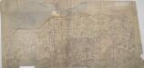
Boughton Street, Kent(002OSD000000015U00372000)
The lack of detail shows this to be an unfinished drawing. Buildings are drawn in outline only. Woodland is indicated by a general representation of tree tops en masse.
Boughton Street, Kent(002OSD000000015U00371000)
Drawing showing Boughton Street, Whitstable & Herne Bay in north Kent. Pencil lines cover this drawing, Radiating from elevated sites where the surveyor took angular measurements to plot topographical features. Several corrections have been made in black ink. Windmills are drawn in elevation at Millstrood, In the centre of the sheet.
TR26 & Parts of TR27 - OS 1:25,000 Provisional Series Map
1 : 25000 Topographic maps Ordnance Survey Ordnance Survey
TR16 - OS 1:25,000 Provisional Series Map
1 : 25000 Topographic maps Ordnance Survey Ordnance Survey
Bishopsbourne, Kent
This field sketch provides an instructive contrast to the meticulous detail found in more finished drawings. Working roughly in black ink, the draughtsman has recorded field boundaries, relief and the details of the settlements.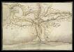
North East Corner of Kent
This is a map of the north east corner of Kent. It forms part of an atlas that belonged to William Cecil Lord Burghley, Elizabeth I’s Secretary of State. Burghley used this atlas to illustrate domestic matters. It is though to be by William Lambard. Lambard is known to have been working in Kent during the 1580s and 1590s, producing a map of the beacon network of Kent in 1585. Here the waterways are the dominant feature. These were the most effective mode of transport and knowledge of them was vital in order to protect the country as they made it possible to manoeuvre troops and weaponry in large quantities relatively fast. Given the fact that Lambard was engaged in producing a map of the beacon network of the area, it is likely that this map was also produced with the idea of defence in mind. The threat from Spain reached it climax in the 1580s with the events of the Sapnish Armada in 1588. The earlier years of the decade saw defensive preparations take place and the proximity of this area to London would have made a detailed understanding of its communication routes vital. Lord Burghley has written on the reverse of the map: "River of Stowre betwixt Sandwych and Fordwych" highlighting that the important feature of the map is indeed the waterways. [Lambard, William]
Faversham (Hills) - OS One-Inch Revised New Series
1 : 63360 Topographic maps Ordnance Survey Ordnance Survey
Faversham (Outline) - OS One-Inch Revised New Series
1 : 63360 Topographic maps Ordnance Survey Ordnance Survey
Partie de l'Angleterre
1 : 110000 Anglie jižní Fricx, Eugene Henry Harrewyn, Jacques chez Eugene Henry Fricx
East Kent - OS One-Inch Map
1 : 63360 Topographic maps Ordnance Survey Ordnance Survey