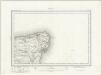
Maps of Canterbury

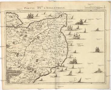
Partie de l'Angleterre
1 : 110000 Anglie jižní Fricx, Eugene Henry Harrewyn, Jacques chez Eugene Henry Fricx
East Kent - OS One-Inch Map
1 : 63360 Topographic maps Ordnance Survey Ordnance Survey
To the Right Honorable the Master, Wardens, and Elder Brethren, of the Trinity House, this chart of the Downs and Margate Roads is ... dedicated
1 : 56000 Heather, W. (William) Heather, W. (William)
Carte réduite de la rade des dunes
1 Karte : Kupferdruck ; 56 x 40 cm Bellin s.n.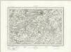
Canterbury (Outline) - OS One-Inch Revised New Series
1 : 63360 Topographic maps Ordnance Survey Ordnance Survey
Canterbury (Hills) - OS One-Inch Revised New Series
1 : 63360 Topographic maps Ordnance Survey Ordnance Survey
A topographical-map, of the county of Kent, 14
1 Blatt : 54 x 71 cm A. Dury, W. Herbert
A Chart of the Isle of Thanet and Sandwich Marsh
This is a plan of Sandwich Haven, the River Stour, the Isle of Thanet and the Wantsum Channel, Kent,possibly dating from around 1548. At this time the Sandwich harbour was in a state of decay. The course of the lower part of the River Stour, between Sandwich and the sea is a series of bends. This made it difficult to navigate, especially with the increasing lengths of 16th century ships, and also prone to becoming blocked with deposits of silt. The idea of making a new artificial channel directly east between Sandwich and the sea was proposed by the military engineer John Rogers, as a way to solve the problem. Although work started on the new channel during the reign of Edward VI it was abandoned with nothing more occurring until 1559 when a new report was submitted. This report suggested that the cut be made south of the line proposed by Rogers as here the marsh land was lower and a deep channel at high water would be easier to excavate. The author of this new report and the map which accompanies it are unknown. The only name on the map is Littlejoy which is written under the compass star. The map is drawn at a scale of 7 inches to 10 miles. Littlejoy
Canterbury (Kent)
Canterbury is the largest settlement featured on this drawing, with barracks recorded nearby. The draughtsman has also noted two military batteries along the coast, roughly level with Sandwich. Produced against the background of the Napoleonic Wars, the Ordance Survey drawings show a clear preoccupation with defensive structures, particularly along the vulnerable south coast. On this map, Deal Castle, Sandown Castle and Walmer Castle form a line of protection for the Downs anchorage. Commissioned by Henry VIII in the late 1530s, they were built as a defence against possible invasion after his divorce from Catherine of Aragon angered French and Spanish Catholics. The draughtsman has delineated the distinctive petal formation of Deal Castle, built to resemble the Tudor Rose.
A topographical-map, of the county of Kent, 15
1 Blatt : 54 x 71 cm A. Dury, W. Herbert
A topographical-map, of the county of Kent, 9
1 Blatt : 54 x 70 cm A. Dury, W. Herbert
St Margaret's Bay
1 : 21120 This rough field sketch of the Kentish coastline was produced on about 12 pieces of thin, irregularly cut, paper which were then joined and laid on thick paper. There is considerable mismatch of detail at the joins. The plan runs from the Strait of Dover, through Dover Castle, St Margaret's Bay, Kingsdown, Walmer Castle and Deal. The red colouring normally used to distinguish buildings in settlement areas was not added to this drawing.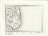
Dover (Outline) - OS One-Inch Revised New Series
1 : 63360 Topographic maps Ordnance Survey Ordnance Survey
Dover (Hills) - OS One-Inch Revised New Series
1 : 63360 Topographic maps Ordnance Survey Ordnance Survey
Faversham (Hills) - OS One-Inch Revised New Series
1 : 63360 Topographic maps Ordnance Survey Ordnance Survey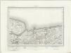
Faversham (Outline) - OS One-Inch Revised New Series
1 : 63360 Topographic maps Ordnance Survey Ordnance Survey
A topographical-map, of the county of Kent, 20
1 Blatt : 54 x 71 cm A. Dury, W. Herbert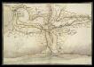
North East Corner of Kent
This is a map of the north east corner of Kent. It forms part of an atlas that belonged to William Cecil Lord Burghley, Elizabeth I’s Secretary of State. Burghley used this atlas to illustrate domestic matters. It is though to be by William Lambard. Lambard is known to have been working in Kent during the 1580s and 1590s, producing a map of the beacon network of Kent in 1585. Here the waterways are the dominant feature. These were the most effective mode of transport and knowledge of them was vital in order to protect the country as they made it possible to manoeuvre troops and weaponry in large quantities relatively fast. Given the fact that Lambard was engaged in producing a map of the beacon network of the area, it is likely that this map was also produced with the idea of defence in mind. The threat from Spain reached it climax in the 1580s with the events of the Sapnish Armada in 1588. The earlier years of the decade saw defensive preparations take place and the proximity of this area to London would have made a detailed understanding of its communication routes vital. Lord Burghley has written on the reverse of the map: "River of Stowre betwixt Sandwych and Fordwych" highlighting that the important feature of the map is indeed the waterways. [Lambard, William]
Dover (Kent)
The cliffs of Dover are shown almost pictorially on this plan, with dark striations indicating steepness. Relief is shown elsewhere by shading and interlining ('hachuring'). Field boundaries are observed. The sandy coast is represented by a speckled pattern and grassland by a green wash. Dover Castle is seen in plan, with dark hachure lines depicting the steep underlying rocks. The castle, known as the 'Key to England', was a site of unique strategic importance, affording the shortest crossing point of the English Channel to continental Europe. Its defences were improved during the Napoleonic conflicts. Special tunnels were even bored beneath the keep for emergency entrance and exit. This drawing was surveyed while the war was at its most ferocious, yet no batteries are recorded.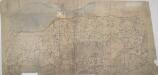
Boughton Street, Kent(002OSD000000015U00372000)
The lack of detail shows this to be an unfinished drawing. Buildings are drawn in outline only. Woodland is indicated by a general representation of tree tops en masse.
A topographical-map, of the county of Kent, 10
1 Blatt : 54 x 71 cm A. Dury, W. Herbert
Margate, Kent
Drawing showing the Isle of Thanet in Kent, including Reculver, Margate and Ramsgate. Pencil lines radiate from central points on this plan, indicating the locations from which the surveyor took angular measurements to plot the relative positions of prominent features in the landscape. The coastline is carefully observed. Rocky outcrops are noted pictorially and sand indicated by a dotted yellow tint. The pier at Ramsgate is recorded along with the harbour gate. Several corrections appear in black ink. Windmills are shown in elevation.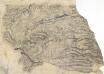
Folkstone (Kent)
Drawing of an area to the east of Folstone in Kent, showing Hawkinge and West Hougham. Dense brushwork interlining ('hachuring') is used in this plan to indicate the contours of the land. Wavy lines indicate woodland. Compared to the later surveys, this drawing is very crude, suggesting it is a preliminary sketch taken in the field.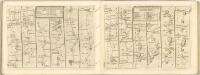

A topographical-map, of the county of Kent, 19
1 Blatt : 54 x 71 cm A. Dury, W. Herbert
Boughton Street, Kent(002OSD000000015U00371000)
Drawing showing Boughton Street, Whitstable & Herne Bay in north Kent. Pencil lines cover this drawing, Radiating from elevated sites where the surveyor took angular measurements to plot topographical features. Several corrections have been made in black ink. Windmills are drawn in elevation at Millstrood, In the centre of the sheet.
Ellham (Kent)
1 : 21120 This is a very rough pencil and ink plan of a rural section of the North Downs in Kent. It was drawn on pieces of irregularly cut tracing paper, which were then joined and mounted on thick paper. The map was draughted in the field to augment the angle and distance measurements recorded in the Ordnance Survey field books. Heavy brushwork interlining ('hachuring') depicts relief, while dotted lines indicate field boundaries around agricultural land. These are particularly evident near the main settlements of Ellham and Stelling Minnis.
Margate (Kent)
This drawing shows the area around Margate in Kent. Many red lines can be seen radiating from fixed points. These were used to form a grid to plot the relative positions of the settlements and topographical details. The draughtsman has recorded the layout of the towns in red ink. The pier and harbour of Ramsgate are detailed, showing the gated structure.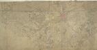
Canterbury, Kent
1 : 21120 The Cathedral City of Canterbury is the large settlement featured at the centre of this drawing. Barracks are recorded nearby. Attention to communications routes conform well to the military and cartographic standards employed by the Survey. The map has been folded, making it hard to read in some places. The top portion of the plan appears to have been torn off.
Ramsgate (Hills) - OS One-Inch Revised New Series
1 : 63360 Topographic maps Ordnance Survey Ordnance Survey