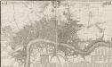
Maps of Hackney
London VII.37 - OS London Town Plan
1 : 1056 Topographic maps Ordnance Survey Ordnance Survey
Insurance Plan of London North & North-East District Vol. E: sheet 4
1 : 480 This detailed 1899 plan of London is one of a series of thirteen sheets in an atlas originally produced to aid insurance companies in assessing fire risks. The building footprints, their use (commercial, residential, educational, etc.), the number of floors and the height of the building, as well as construction materials (and thus risk of burning) and special fire hazards (chemicals, kilns, ovens) were documented in order to estimate premiums. Names of individual businesses, property lines, and addresses were also often recorded. Together these maps provide a rich historical shapshot of the commercial activity and urban landscape of towns and cities at the time. The British Library holds a comprehensive collection of fire insurance plans produced by the London-based firm Charles E. Goad Ltd. dating back to 1885. These plans were made for most important towns and cities of the British Isles at the scales of 1:480 (1 inch to 40 feet), as well as many foreign towns at 1:600 (1 inch to 50 feet). Chas E Goad Limited Chas E Goad Limited
Insurance Plan of London Vol. xi: sheet 387-2
1 : 480 This detailed 1891 plan of London is one of a series of forty seven sheets in an atlas originally produced to aid insurance companies in assessing fire risks. The building footprints, their use (commercial, residential, educational, etc.), the number of floors and the height of the building, as well as construction materials (and thus risk of burning) and special fire hazards (chemicals, kilns, ovens) were documented in order to estimate premiums. Names of individual businesses, property lines, and addresses were also often recorded. Together these maps provide a rich historical shapshot of the commercial activity and urban landscape of towns and cities at the time. The British Library holds a comprehensive collection of fire insurance plans produced by the London-based firm Charles E. Goad Ltd. dating back to 1885. These plans were made for most important towns and cities of the British Isles at the scales of 1:480 (1 inch to 40 feet), as well as many foreign towns at 1:600 (1 inch to 50 feet). Chas E Goad Limited Chas E Goad Limited
Insurance Plan of London Vol. xi: sheet 372-1
1 : 480 This detailed 1891 plan of London is one of a series of forty seven sheets in an atlas originally produced to aid insurance companies in assessing fire risks. The building footprints, their use (commercial, residential, educational, etc.), the number of floors and the height of the building, as well as construction materials (and thus risk of burning) and special fire hazards (chemicals, kilns, ovens) were documented in order to estimate premiums. Names of individual businesses, property lines, and addresses were also often recorded. Together these maps provide a rich historical shapshot of the commercial activity and urban landscape of towns and cities at the time. The British Library holds a comprehensive collection of fire insurance plans produced by the London-based firm Charles E. Goad Ltd. dating back to 1885. These plans were made for most important towns and cities of the British Isles at the scales of 1:480 (1 inch to 40 feet), as well as many foreign towns at 1:600 (1 inch to 50 feet). Chas E Goad Limited Chas E Goad Limited
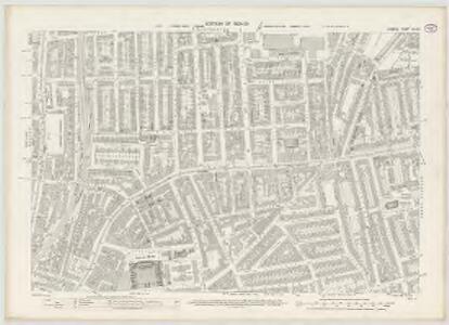
London (1915- Numbered sheets) V.7 (includes: Bethnal Green; Shoreditch; Stepney) - 25 Inch Map
1 : 2500 Topographic maps Ordnance Survey Ordnance Survey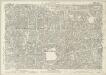
London (Edition of 1894-96) LI (includes: Bethnal Green; Shoreditch; Stepney) - 25 Inch Map
1 : 2500 Topographic maps Ordnance Survey Ordnance Survey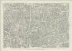
London (First Editions c1850s) XXVII (includes: Bethnal Green; Shoreditch; Stepney) - 25 Inch Map
1 : 2500 Topographic maps Ordnance Survey Ordnance Survey
An Actual Survey of the Parish of St. Leonard in Shoreditch, Middlesex, taken in the Year 1745 by Peter Chassereau. 4
1 : 3000 Plan of the parish of St. Leonard in Shoreditch with title in cartouche at top left, compass at top right, scale bar at bottom centre and key to streets, courts, alleys, squares etc. in table at lower right. Each field in the parish is shown with the name of the landlord or tenant and the dimensions. Chassereau
A Map of the Parish of St. Dunstans Stepney, als. Stebunheath.
A. Churchill
Insurance Plan of London Vol. xi: sheet 386-1
1 : 480 This detailed 1891 plan of London is one of a series of forty seven sheets in an atlas originally produced to aid insurance companies in assessing fire risks. The building footprints, their use (commercial, residential, educational, etc.), the number of floors and the height of the building, as well as construction materials (and thus risk of burning) and special fire hazards (chemicals, kilns, ovens) were documented in order to estimate premiums. Names of individual businesses, property lines, and addresses were also often recorded. Together these maps provide a rich historical shapshot of the commercial activity and urban landscape of towns and cities at the time. The British Library holds a comprehensive collection of fire insurance plans produced by the London-based firm Charles E. Goad Ltd. dating back to 1885. These plans were made for most important towns and cities of the British Isles at the scales of 1:480 (1 inch to 40 feet), as well as many foreign towns at 1:600 (1 inch to 50 feet). Chas E Goad Limited Chas E Goad Limited
Insurance Plan of London Vol. xi: sheet 388-2
1 : 480 This detailed 1891 plan of London is one of a series of forty seven sheets in an atlas originally produced to aid insurance companies in assessing fire risks. The building footprints, their use (commercial, residential, educational, etc.), the number of floors and the height of the building, as well as construction materials (and thus risk of burning) and special fire hazards (chemicals, kilns, ovens) were documented in order to estimate premiums. Names of individual businesses, property lines, and addresses were also often recorded. Together these maps provide a rich historical shapshot of the commercial activity and urban landscape of towns and cities at the time. The British Library holds a comprehensive collection of fire insurance plans produced by the London-based firm Charles E. Goad Ltd. dating back to 1885. These plans were made for most important towns and cities of the British Isles at the scales of 1:480 (1 inch to 40 feet), as well as many foreign towns at 1:600 (1 inch to 50 feet). Chas E Goad Limited Chas E Goad Limited
Insurance Plan of London Vol. XI: sheet 294-1
1 : 480 This detailed 1890 plan of London is one of a series of thirty-one sheets in an atlas originally produced to aid insurance companies in assessing fire risks. The building footprints, their use (commercial, residential, educational, etc.), the number of floors and the height of the building, as well as construction materials (and thus risk of burning) and special fire hazards (chemicals, kilns, ovens) were documented in order to estimate premiums. Names of individual businesses, property lines, and addresses were also often recorded. Together these maps provide a rich historical shapshot of the commercial activity and urban landscape of towns and cities at the time. The British Library holds a comprehensive collection of fire insurance plans produced by the London-based firm Charles E. Goad Ltd. dating back to 1885. These plans were made for most important towns and cities of the British Isles at the scales of 1:480 (1 inch to 40 feet), as well as many foreign towns at 1:600 (1 inch to 50 feet). Chas E Goad Limited Chas E Goad Limited
Insurance Plan of London North & North-East District Vol. E: sheet 3
1 : 480 This detailed 1899 plan of London is one of a series of thirteen sheets in an atlas originally produced to aid insurance companies in assessing fire risks. The building footprints, their use (commercial, residential, educational, etc.), the number of floors and the height of the building, as well as construction materials (and thus risk of burning) and special fire hazards (chemicals, kilns, ovens) were documented in order to estimate premiums. Names of individual businesses, property lines, and addresses were also often recorded. Together these maps provide a rich historical shapshot of the commercial activity and urban landscape of towns and cities at the time. The British Library holds a comprehensive collection of fire insurance plans produced by the London-based firm Charles E. Goad Ltd. dating back to 1885. These plans were made for most important towns and cities of the British Isles at the scales of 1:480 (1 inch to 40 feet), as well as many foreign towns at 1:600 (1 inch to 50 feet). Chas E Goad Limited Chas E Goad Limited
Insurance Plan of London Vol. xi: sheet 384-1
1 : 480 This detailed 1891 plan of London is one of a series of forty seven sheets in an atlas originally produced to aid insurance companies in assessing fire risks. The building footprints, their use (commercial, residential, educational, etc.), the number of floors and the height of the building, as well as construction materials (and thus risk of burning) and special fire hazards (chemicals, kilns, ovens) were documented in order to estimate premiums. Names of individual businesses, property lines, and addresses were also often recorded. Together these maps provide a rich historical shapshot of the commercial activity and urban landscape of towns and cities at the time. The British Library holds a comprehensive collection of fire insurance plans produced by the London-based firm Charles E. Goad Ltd. dating back to 1885. These plans were made for most important towns and cities of the British Isles at the scales of 1:480 (1 inch to 40 feet), as well as many foreign towns at 1:600 (1 inch to 50 feet). Chas E Goad Limited Chas E Goad Limited
Insurance Plan of London Vol. XI: sheet 293
1 : 480 This detailed 1890 plan of London is one of a series of thirty-one sheets in an atlas originally produced to aid insurance companies in assessing fire risks. The building footprints, their use (commercial, residential, educational, etc.), the number of floors and the height of the building, as well as construction materials (and thus risk of burning) and special fire hazards (chemicals, kilns, ovens) were documented in order to estimate premiums. Names of individual businesses, property lines, and addresses were also often recorded. Together these maps provide a rich historical shapshot of the commercial activity and urban landscape of towns and cities at the time. The British Library holds a comprehensive collection of fire insurance plans produced by the London-based firm Charles E. Goad Ltd. dating back to 1885. These plans were made for most important towns and cities of the British Isles at the scales of 1:480 (1 inch to 40 feet), as well as many foreign towns at 1:600 (1 inch to 50 feet). Chas E Goad Limited Chas E Goad Limited
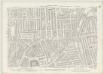
London VII.NE - OS Six-Inch Map
1 : 10560 Topographic maps Ordnance Survey Ordnance Survey
Handy Reference Atlas of London
Edinburgh : John Bartholomew & Co.,
LONDINUM FERACISSIMI ANGLIAE REGNI METROPOLIS
This derivative of Braun & Hogenberg's 1572 map of London was published in Belle Forest's 'La Cosmographie universelle de tout le monde'. The map's title features at the top of the plate, flanked by Tudor and city arms. Descriptive notes in French appear at bottom left and bottom right, with figures of merchants at bottom centre. The map is similar in detail to the 'Copperplate Map', the earliest printed map of London of which no complete copy survives. Merchant ships, cranes, mills, bull- and bear-baiting pits, the large tennis courts at Westminster and the stags in St. James’s are examples of London business and leisure activities. Walled gardens, elegant churches and livery halls testify to the high quality of life enjoyed by its citizens. Braun, Georg & Hogenberg, Frans
Militärgeographische Angaben über England.
Generalstab des Heeres, Abteilung für Kriegskarten u. Vermessungswesen IV. Mil.-Geo
Insurance Plan of London North & North-East District Vol. E: Key Plan
1 : 21120 This "key plan" indicates coverage of the Goad 1899 series of fire insurance maps of London that were originally produced to aid insurance companies in assessing fire risks. The building footprints, their use (commercial, residential, educational, etc.), the number of floors and the height of the building, as well as construction materials (and thus risk of burning) and special fire hazards (chemicals, kilns, ovens) were documented in order to estimate premiums. Names of individual businesses, property lines, and addresses were also often recorded. Together these maps provide a rich historical shapshot of the commercial activity and urban landscape of towns and cities at the time. The British Library holds a comprehensive collection of fire insurance plans produced by the London-based firm Charles E. Goad Ltd. dating back to 1885. These plans were made for most important towns and cities of the British Isles at the scales of 1:480 (1 inch to 40 feet), as well as many foreign towns at 1:600 (1 inch to 50 feet). Chas E Goad Limited Chas E Goad Limited
Charles Booth's 'Descriptive Map of London Poverty'. Detail showing the City of London and the East End
The East End of London is the hell of poverty. Like one enormous black, motionless giant kraken, the poverty of London lies there in lurking silence and encircles with its mighty tentacles the life and wealth of the City. So wrote J H Mackay in 1891. It was acknowledged that the blame lay with overcrowded housing and with a surplus of labour, which kept wages low for those lucky enough to find work. Statistics for 1888 showed that the East End had 8,465 official paupers - people 'living rough'. According to Charles Booth's survey in 1889, over a third of its inhabitants lived on or below the margin of poverty. His 17-volume survey included this coloured-coded map indicating London's poverty and prosperity street by street. The key to the colours used is as follows: Gold: Upper-middle and Upper classes.Wealthy. Red: Well-to-do. Middle-class. Pink: Fairly comfortable. Good ordinary earning. Purple: Mixed. Some comfortable, others poor. Pale Blue: Poor. 18s. to 21s. a week for moderate family Dark blue: Very poor, casual. Chronic want. Black: Lowest class. Vicious, semi-criminal. Booth, Charles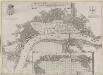
Grundstriss der Statt LONDON wie solche vor und nach dem Brand anzuschen sampt dem Newen Model wie selbige wid rum Auffgebauwet werden solle
This is a map of London immediately after the great fire of 1666. The map was first published by the Merian Heirs of Frankfurt in 1677, appearing in the anthology "Theatri Europei". The title appears in a scroll along the top, flanked by royal and city arms. Notes on shading and an inset plan of Robert Hooke’s designs for rebuilding the city appear in another scroll at the foot of the plate. Hooke's plan is given with its own key and reference table.
LONDON 206
This plan for a survey of London was published in Volume VIII of ‘Encyclopaedia Londinensis' in 1814. The plan's title appears above the plan, with a compass star at the top right. St. Paul's Cathedral and other prominent buildings are shown pictorially, with other places of interest indicated by numbers. Jones, George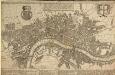
A POCKET MAP OF LONDON, WESTMINSTER AND SOUTHWARK With ye New Buildings to ye Year 1739
The map's title appears in English and Dutch in a panel along the top. A descriptive note features below the title, with royal arms at top left, city arms at top right and fares of hackney coaches and water ferries in a panel below the plan. The map shows the new bridge at Westminster and represents prominent buildings and landmark three-dimensionally. De Leth, Hendrick
PLATTE GRONDT Der Verbrande Stadt LONDON
This map was published in Amsterdam aftermath the great fire of 1666. The title in a banner at top right, flanked by City and Royal arms. The design for rebuilding the City is inset in a panel at top left, with an engraved view of the fire in a banner at bottom centre. Below the plan is a description of the fire in Dutch, French and English with a key to streets and buildings. Doornick, Marcus Willemsz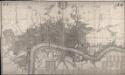
This Actual Survey Of London Westminster Southwark Is Humbly Dedicated To Ye Ld. Mayor & Court of Aldermen
Morden, Robert; Lea, Philip Covens et Mortier
The LONDON DIRECTORY, or a New & Improved PLAN of LONDON, WESTMINSTER, & SOUTHWARK;
This is a reissue of a map first published in 1771 by John Bowles. Bowles' name has been removed, with the imprint of there issuer, Robert Wilkinson, appearing instead. This map highlights the London Wall in red, showing with arrows the direction of water-flow in the Thames. Bowles, John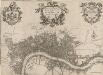
A new PLAN of LONDON, WESTMINSTER and SOUTHWARK 85
This map of London, Westminster and Southwark was published in John Strype's 1720''Survey of the Cities of London and Westminster''. The map's title is at top centre in ornamental cartouche, surrounded by cherubs, fruits and mythological figures. Dedication to Sir George Thorold, Lord Mayor of London appears at top right, facing the city arms at top left. A compass star is depicted at middle right and a scale bar at bottom right. Strype, John
Rowe's map of London, westminster and Southwark, exhibiting the various improvements to the year 1804, detail showing the London and west india Docks
A canal and the two West India docks now cut across the neck of the Isle of Dogs to provide shipping with a shortcut across its marshy peninsular. A wall around its edge holds back the tidal Thames while windmills on the windy west side pump water from the marsh. As industry spreads, wealthy residents are lured away to the fashionable new suburbs rising to the west of London. Turnpikes appear, on the Hackney Road for example: an indication of the growing need for good roads and the money to maintain them. From the tangle of older streets, the line of the proposed new Commercial Road shoots straight across the open fields. Rowe