Maps of Islington
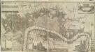
Grundstriss der Statt LONDON wie solche vor und nach dem Brand anzuschen sampt dem Newen Model wie selbige wid rum Auffgebauwet werden solle
This is a map of London immediately after the great fire of 1666. The map was first published by the Merian Heirs of Frankfurt in 1677, appearing in the anthology "Theatri Europei". The title appears in a scroll along the top, flanked by royal and city arms. Notes on shading and an inset plan of Robert Hooke’s designs for rebuilding the city appear in another scroll at the foot of the plate. Hooke's plan is given with its own key and reference table.
PLATTE GRONDT DER STADT LONDON MET AENWYSINGHE HOE DIE AFGEBRANDT
This map was published in Amsterdam after the great fire of 1666. The title appears along the top of the manuscript, with the key to parish churches (in scrolls) at top left and top right, and dividers at top right. An engraving of the great fire is inset at bottom right, entitled "BRANDENT LONDON". Below the plan, the fire is described in Dutch and French. Wit, Frederick de
LONDON 206
This plan for a survey of London was published in Volume VIII of ‘Encyclopaedia Londinensis' in 1814. The plan's title appears above the plan, with a compass star at the top right. St. Paul's Cathedral and other prominent buildings are shown pictorially, with other places of interest indicated by numbers. Jones, George
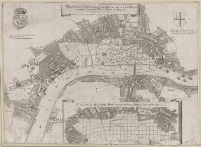
PLATTE GRONDT DER STADT LONDON MET NIEUW MODEL EN HOE DIE AFGEBRANDT IS
This later edition of the Frederick de Wit's 1666 plan features minor alterations to the title and some additions on the outskirts of the city. The map's title appears along the top, with the key to parish churches (in scrolls) at top left and top right and dividers at top right. An engraving depicting the city on fire is inset at bottom right. Below the plan, a description of the fire is reported in Dutch and French. This edition of the map shows cherubs holding the reference tables and a waterman with oars leaning against the view of the city. Wit, Frederick de
PLATTE GRONDT Der Verbrande Stadt LONDON
This map was published in Amsterdam aftermath the great fire of 1666. The title in a banner at top right, flanked by City and Royal arms. The design for rebuilding the City is inset in a panel at top left, with an engraved view of the fire in a banner at bottom centre. Below the plan is a description of the fire in Dutch, French and English with a key to streets and buildings. Doornick, Marcus Willemsz
A Plan of LONDON and WESTMINSTER, shewing the Forts erected by order of the Parliament in 1643, and the Desolation by the Fire in 1666
This is a retrospective plan of London, showing the1643 defences for the civil war and the area destroyed by the Great Fire. These defences were built to protect the city from attacks by Charles I and his 15,000 Royalist troops. Here all 23 forts are shown, linked by eighteen miles of ramparts. The Royalists never attempted to enter London because the King made a tactical withdrawal.
A PLAN of the City and Suburbs of LONDON as fortified by Order of Parliament in the Years 1642 and 1643.
This is a retrospective plan of London showing the defences for the civil war, established after an Act of Parliament in 1642. These built to protect the city from attacks by Charles I and his 15,000 Royalist troops. Here all 23 forts are shown, linked by eighteen miles of ramparts. The Royalists did not attempt to enter London as the King made a tactical withdrawal. Fort 6 was the first to be built, with a commanding prospect of Finsbury Fields. Vertue, G.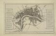
Plan of the city and suburbs of London as fortified by Order of Parliament in the years 1642 and 1643

The London directory, or a new & improved plan of London, Westminster, & Southwark, with the adjacent country, the new buildings, the new roads, and the late alterations by opening of new streets, & widening of others
1 : 15840
A Mapp of the Cityies of LONDON & WESTMINSTER & BURROUGH of SOUTHWARK with their Suburbs and the Addition of the New Buildings
The title of this map of London, Westminster and Southwark appears along the top, with a reference table (flanked by sword and mace-bearer) at top left, a figure of Mercury (with the city arms on his shield) at top centre, and a second reference table below city arms at top right. The key to places in Southwark appear in a table at St. George's Fields, with compass star and scale bar at bottom centre and an allegorical figure of Father Thames at bottom right. John Oliver first issued this map in 1680.This is a later edition published and sold by John Bowles from his shop at the Black Horse in Cornhill. Oliver, John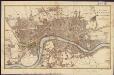
A plan of London, Westminster, and Southwark
1 : 26750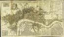
A new and exact plan of the cities of London and Westminster & the borough of Southwark to this present year
1 Plan auf 2 Blättern : Kupferdruck ; 53 x 101 cm Sayer; Bowen printed and published according to act of parliament by Robert Sayer opposite Fetter lane Fleet street
London, Westminster, and Southwark
The map reports all the street names in London, Westminster and Southwark, with the scale bar given at bottom left. Faden, William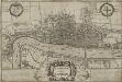
LONDINUM Vulgo LONDON
This later edition of Braun & Hogenberg's map of London and Westminster was published in Janssen's 'Illustrorem Principumque Urbium Septentrionalium Europae'. The map's title appears in a cartouche at the foot of the plate, replacing the figures of merchants of the first edition. Tudor arms feature top right, with city arms at top left and descriptive notes to the bottom right and bottom left. The map is similar in detail to the 'Copperplate Map', the earliest printed map of London of which no complete copy survives. Merchant ships, cranes, mills, bull and bear baiting pits, the large tennis courts at Westminster and the stags in St. James’s are examples of London's business and leisure activities. Walled gardens, elegant churches and livery halls testify to the high quality of life enjoyed by its citizens. Braun, Georg & Hogenberg, Frans
PLAN DE LA VILLE DE LONDRES
This small map of London appeared in a book entitled "Memoires et Observations faites par un Voyageur en Angleterre", published in France by Henry Van Bulderen in 1698. The map is a much-reduced derivative of Joannes de Ram's plan of 1690. This edition features title at top left, city arms at top right and a panorama of London, based on Matthaeus Merian’s view of the city, in a panel below the plan. Ram, Joannes de
NEW PLAN OF LONDON
This map was printed in black on white and appeared in the “Guide to Knowledge" anthology of 1839. The map's title, imprint and scale bar appear at bottom right. It shows the proposed Thames Tunnel, linking Wapping and Rotherhithe, as well as the Hungerford Bridge and the Greenwich and Birmingham railway lines. Archer, Joshua
Plan of the City of LONDON before the Fire Anno Domini 1666.
This is a retrospective plan of the City of London before the great fire of 1666. Place names are indicated by an alphanumeric key.
Plan of London, West.r and Southwark, w.th y.e Riv.r Thames, as they were survey.d and publisht by Authority toward y.e latter end of y.e reign of Queen Elizaabeth, or about y.e year of our Lord 1600.
This is the fourth edition of Braun &Hogenberg's map view of London. The title in cartouche at the foot of the plate replaces the figures of merchants from the earlier editions. Tudor arms feature at top right, with the city arms at top left and descriptive notes at bottom right and bottom left. Published in Hatton's 'A New View of London; or, an Ample Account of that City', the map is similar in detail to the 'Copperplate Map', the earliest printed map of London of which no complete copy survives. Merchant ships, cranes, mills, bull- and bear-baiting pits, the large tennis courts at Westminster and the stags in St. James’s are examples of London's business and leisure activities. Walled gardens, elegant churches and livery halls testify to the high quality of life enjoyed by its citizens. Braun, Georg & Hogenberg, Frans
LONDINI ANGLIAE REGNI METROPOLIS 70
The title of this map of London, Westminster and Southwark appears along the top. Figures of cherubs are depicted at top left facing the reference table at top right. The royal and city arms are illustrated at the foot of the plate, with a key to places in Southwark and compass rose at lower left, facing the portraits of King William III and Queen Mary at bottom right. The panorama of the city which features in the panel below the plan is based on Matthaeus Merian’s view published in "Theatrum Europeum" in 1720. Joannes de Ram had already published an identical map of the city. His name was removed from the plan when French mapmaker, engraver and publisher Jacques de la Feuille married de Ram’s widow and took over his publishing business. Feuille, Jacques de la
The LONDON DIRECTORY, or a New & Improved PLAN of LONDON, WESTMINSTER, & SOUTHWARK
This is the fifth edition of a map originally published in 1771 by John Bowles. His name has been replaced by the imprint of Robert Wilkinson, the reissuer. This map highlights the London Wall in red, and colours the city in pink. It uses arrows to show the direction of water-flow in the Thames. There are some additions to the map near Foundling Hospital. Bowles, John
LONDINUM FERACISSIMI ANGLIAE REGNI METROPOLIS
This derivative of Braun & Hogenberg's 1572 map of London was published in Belle Forest's 'La Cosmographie universelle de tout le monde'. The map's title features at the top of the plate, flanked by Tudor and city arms. Descriptive notes in French appear at bottom left and bottom right, with figures of merchants at bottom centre. The map is similar in detail to the 'Copperplate Map', the earliest printed map of London of which no complete copy survives. Merchant ships, cranes, mills, bull- and bear-baiting pits, the large tennis courts at Westminster and the stags in St. James’s are examples of London business and leisure activities. Walled gardens, elegant churches and livery halls testify to the high quality of life enjoyed by its citizens. Braun, Georg & Hogenberg, Frans
The LONDON DIRECTORY, or a New & Improved PLAN of LONDON, WESTMINSTER, & SOUTHWARK; 152
Robert Laurie was a fine mezzotint engraver and regular exhibitor at the Society of Artists in the 1770s. He acquired the stock of surveyor John Sayer’s in 1794 and, in partnership with James Whittle, founded the map publishing firm Laurie & Whittle. This map is very similar to the 1765 map by Robert Sayer and is probably from the same plate. Blackfriars Bridge is shown along with its proposed approaches. Laurie, Robert, and Whittle, James.
The LONDON DIRECTORY, or a New & Improved PLAN of LONDON,
Robert Sayer, the surveyor, traded as a map publisher and print seller in Fleet Street in the latter half of the 18th Century. Between 1751 and 1770and againfrom1784to 1794, he published maps under his own name or under the imprint of Sayer and Bennett. This is the 11th edition of a map published 14 times over a period of 27 years. During this time Robert Sayer became joined in partnership with John Bennett, with their joint imprint appearing on the third to eighth editions. The area of the city is highlighted in pink. A table of references for churches and public buildings appears below the map. In 1794 Sayers stock was acquired by Robert Laurie who founded the map publishing firm of Laurie & Whittle, with his friend James Whittle. Sayer, Robert
The LONDON DIRECTORY, or a New & Improved PLAN of LONDON, WESTMINSTER & SOUTHWARK;
The title of this map appears along the top, with a key in panel below the plan and letters along the borders for reference. Sayer's maps of London, largely derivative, were issued with few alterations throughout the middle years of the 18th Century. This is a later edition of a map he first published in 1765, updated to include the approaches to Blackfriars Bridge, which did not feature in the first edition. Sayer, Robert
LONDON 76
This small map of London and suburbs was included in a small 1707French travel book, "Les Delices de la Grande Bretagne". It features a compass rose at bottom right, and a title with reference panel below the plan. Bevereel, James
The LONDON DIRECTORY, or a New & Improved PLAN of LONDON, WESTMINSTER, & SOUTHWARK; 157
This is the eighth edition of the an original 1765Sayer map. Bennett’s name was added to the imprint of the third edition of the map, published in 1776. The two men were in partnership between 1770 and 1787.Their business was taken over by Laurie and Whittle in 1792. R. Sayer & J. Bennett
A new mapp of the city of London &c. : with the many additionall buildings and new streets anno 1723 in a playne
1 : 7300 Taylor, Thomas, fl. 1670-1730 Printed and sold by Thomas Taylor at the Golden Lyon in Fleet Street
The LONDON DIRECTORY, or a New & Improved PLAN of LONDON, WESTMINSTER, & SOUTHWARK; 182
This map is a reissue of a map published in 1771 by John Bowles. Bowles's name has been replaced by that of Robert Wilkinson, the reissuer. A table of references to churches and public buildings appears below the map. The built-up area of the city is stippled, with other built-up areas done in crosshatching. Coloured lines delineate individual city wards. Bowles, John
LONDINI ANGLIAE REGNI METROPOLIS 71
This map of London, Westminster and Southwark was issued in Peter Van der Aa's "La Galerie Agreable du Monde: Grande Bretagne et Irlande" (Vol. I, Plate 8). It is a later edition of a map first published in Amsterdam byJoannes de Ram at the end of the 17th Century. This edition features title along the top, a key to places in Southwark in cartouche at top left, a reference table at top right, and a bird's-eye view of Westwood Park in Worcestershire at the foot of the plate. The city arms, publisher's imprint, and a monument bearing the title in French appear towards the bottom of the sheet. Aa, Peter van der