Maps of Landkreis Dillingen an der Donau

Nieuwe Kaart, van t'Land Donawert, en Hochstett &c.
1 : 200000 Mollova mapová sbírka Visscher, Nicolaes Jansz. Visscher, Nicolaus II.
Neueste Karte von der Markgrafschaft Burgau zu den oesterreichischen Vorlanden in Schwaben gehörig
1 Karte : Kupferdruck ; 54 x 47 cm Probst; Sprengler Johann Michael Probst
Novissima delineatio Marchionatus Burgoviae
1 : 150000 Mollova mapová sbírka Michal, Jacques de Seutter, Matthäus

Nova et accurata Territorii Vlmensis cum Dominio Wainensi Descriptio
1 : 100000 Mollova mapová sbírka Lauterbach, Johann Christoph Homann, Johann Baptista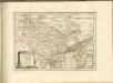
Geographica Provinciarum Sveviae Descriptio =
Mollova mapová sbírka Hurter, Johann Christoph Bodenehr, Gabriel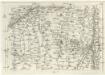
Geographica Provinciarum Sveviae Descriptio =
Mollova mapová sbírka Hurter, Johann Christoph Bodenehr, Johann Georg
Schlacht bey Neresheim am 11.ten August 1796
1 : 170000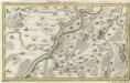
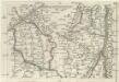
Lauingen und Confinen
1 : 140000 Mollova mapová sbírka Bodenehr, Gabriel Bodenehr, Gabriel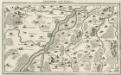
Lauingen und Confinen
Mollova mapová sbírka Bodenehr, Gabriel Bodenehr, Gabriel
La Battaille de Hoechstedt
1 : 50000 Mollova mapová sbírka Husson, Pieter Husson, Pierre
Plan of the glorious Battle of Hochstet
Plan of the glorious Battle of Hochstet [or Blenheim]. ... For Tindal's Continuation of Rapin's History of England. [London]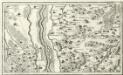
Thierhaupten, Pöttmess, Gumpenberg, Küebach a okolí]
Mollova mapová sbírka Bodenehr, Gabriel Bodenehr, Gabriel
A plan of the famous victory at Bleinem obtained by His Grace the Duke of Malborough over the Elector of Bavaria and the Marechals Tallard and Marcin, the 13th August, 1704 S.N
1 : 20000 J. van Vianen fecit [Amsterdam] : Reynerus Leers excudit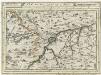
Ulm mit dero Gegend auf 2 Stund.
1 : 150000 Mollova mapová sbírka Bodenehr, Gabriel Bodenehr, Gabriel
Abriss des Territorii Ulmensis Ultra-Danubialis, Sambt denen Beeden Wildpan. bezürcken
1 : 100000 Mollova mapová sbírka Mayer, Bartholomaeus Bodenehr, Gabriel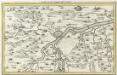
Ulm mit der Gegend auf 1 1/4 Stund
Mollova mapová sbírka Bodenehr, Gabriel Bodenehr, Gabriel
Augspurg mit umliegender Gegend und dabey verschanzten Französisch-Bayrischen Lager
1 : 40000 Mollova mapová sbírka Weigel, Johann Christoph Weigel, Christoph I.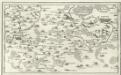
Geislingen, Heydenheim, Gienden a okolí]
Mollova mapová sbírka Bodenehr, Gabriel Bodenehr, Gabriel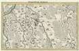
Marggraffschafft Burgau
Mollova mapová sbírka Bodenehr, Gabriel Bodenehr, Gabriel
Meßtischblatt [7527] : Schotthof, 1930
1 : 250000 Schotthof. - 1:25000. - Stuttgart, 1930. - 1 Kt.
Meßtischblatt [7526] : Langenau, 1926
1 : 250000 Langenau. - 1:25000. - Stuttgart, 1926. - 1 Kt.
Meßtischblatt [7526] : Langenau, 1912
1 : 250000 Langenau. - 1:25000. - Stuttgart, 1912. - 1 Kt.
Meßtischblatt [7427] : Sontheim a.d. Brenz, 1930
1 : 250000 Sontheim a.d. Brenz. - 1:25000. - Stuttgart, 1930. - 1 Kt.
Meßtischblatt [7426] : Dettingen a. Albuch, 1926
1 : 250000 Dettingen a. Albuch. - 1:25000. - Stuttgart, 1926. - 1 Kt.
Meßtischblatt [7327] : Giengen, 1931
1 : 250000 Giengen. - 1:25000. - Stuttgart, 1931. - 1 Kt.
Meßtischblatt [7326] : Heidenheim, 1928
1 : 250000 Heidenheim. - 1:25000. - Stuttgart, 1928. - 1 Kt.
Accurater Grund-Riss sambt der Situation und Attaque des H. Röm. Reichs freyen und berühmten Stadt Ulm
Mollova mapová sbírka Bodenehr, Gabriel Bodenehr, Gabriel


