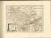
Maps of Dillingen a.d.Donau
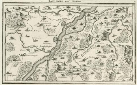
Lauingen und Confinen
Mollova mapová sbírka Bodenehr, Gabriel Bodenehr, Gabriel
Lauingen und Confinen
1 : 140000 Mollova mapová sbírka Bodenehr, Gabriel Bodenehr, Gabriel
Plan of the glorious Battle of Hochstet
Plan of the glorious Battle of Hochstet [or Blenheim]. ... For Tindal's Continuation of Rapin's History of England. [London]
Meßtischblatt [7427] : Sontheim a.d. Brenz, 1930
1 : 250000 Sontheim a.d. Brenz. - 1:25000. - Stuttgart, 1930. - 1 Kt.
La Battaille de Hoechstedt
1 : 50000 Mollova mapová sbírka Husson, Pieter Husson, Pierre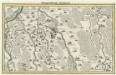
Marggraffschafft Burgau
Mollova mapová sbírka Bodenehr, Gabriel Bodenehr, Gabriel
Meßtischblatt [7527] : Schotthof, 1930
1 : 250000 Schotthof. - 1:25000. - Stuttgart, 1930. - 1 Kt.
Novissima delineatio Marchionatus Burgoviae
1 : 150000 Mollova mapová sbírka Michal, Jacques de Seutter, Matthäus
Nieuwe Kaart, van t'Land Donawert, en Hochstett &c.
1 : 200000 Mollova mapová sbírka Visscher, Nicolaes Jansz. Visscher, Nicolaus II.
Neueste Karte von der Markgrafschaft Burgau zu den oesterreichischen Vorlanden in Schwaben gehörig
1 Karte : Kupferdruck ; 54 x 47 cm Probst; Sprengler Johann Michael Probst
Suevia Universa :
1 : 170000 Mollova mapová sbírka Michal, Jacques de Seutter, Matthäus Seutter, Matthäus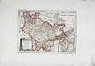
Die freye Reichsstadt Ulm mit ihrem Gebiete
1 Karte : Kupferdruck ; 19 x 27 cm Reilly F. J. J. von Reilly
München - Augsburg - Ulm

Theatrum des Krieges in der Marggrafschaft Burgau
Mollova mapová sbírka Stridbeck, Johann Stridbeck, Johann II
Suevia universa IX. tabulis delineata, 3
1 Blatt : s.n.
Augsburg
1 : 200000 Herder, Benjamin
Geographica Provinciarum Sveviae Descriptio =
Mollova mapová sbírka Hurter, Johann Christoph Bodenehr, Johann Georg
Umgegend von Ulm
1 : 200000 Kartographischen Abtheilung konigl Preuss
Geographica Provinciarum Sveviae Descriptio =
Mollova mapová sbírka Hurter, Johann Christoph Bodenehr, Gabriel
Geographica Provinciarum Sveviae Descriptio =
Mollova mapová sbírka Hurter, Johann Christoph Bodenehr, Johann Georg

172. Nördlingen, uit: Topographische Uebersichtskarte des Deutschen Reiches / herausgegeben v. d. Kartogr. Abt. d. Königl. Preuß. Landesaufnahme
1 : 200000 titelvariant: Topogr. Übersichtskarte des Deutschen Reiches; Annotatie: Titel boven bladen ook: Topogr. Übersichtskarte des Deutschen Reiches; Annotatie geografische gegevens: Op elk blad twee maatstokken: 10 Kilometer = 5,5 cm; 1 geogr. Meile = 3,6 cm; Legenda onder op elk blad Königlich Preußische Landesaufnahme. Kartographische Abtheilung [S.l : Königlich Preußische Landesaufnahme, Kartographische Abtheilung]
Nova et accurata Territorii Vlmensis cum Dominio Wainensi Descriptio
1 : 100000 Mollova mapová sbírka Lauterbach, Johann Christoph Homann, Johann Baptista
Nova et accurata territorii Vlmensis cum dominio Wainensi descriptio
1 Karte : Kupferdruck ; 47 x 56 cm Lauterbach; Homann Johann Baptist Homann
Nova et accurata territorii Vlmensis cum dominio Wainensi descriptio
1 Karte : Kupferdruck ; 47 x 56 cm Lauterbach; Homann Johann Baptist Homann
Augsburg mit der gegend auf 2 Stunden.
1 : 150000 Mollova mapová sbírka Bodenehr, Gabriel Bodenehr, Gabriel
Nova et accurata territorii Vlmensis cum dominio Wainensi descriptio
1 : 100000 Bádensko-Württembersko (Německo) Lauterbach, Johann Christoph Homann, Johann Baptist Ioh. Baptista Homann
Schlacht bey Neresheim am 11.ten August 1796
1 : 170000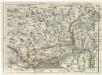
Geographica Provinciarum Sveviae Descriptio =
Mollova mapová sbírka Hurter, Johann Christoph Bodenehr, Gabriel