Maps of Buttenwiesen

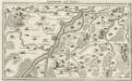
A plan of the famous victory at Bleinem obtained by His Grace the Duke of Malborough over the Elector of Bavaria and the Marechals Tallard and Marcin, the 13th August, 1704 S.N
1 : 20000 J. van Vianen fecit [Amsterdam] : Reynerus Leers excudit
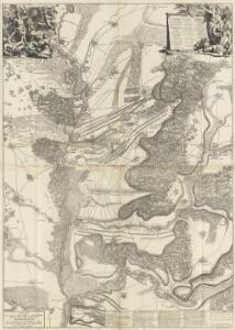
Plan of the glorious Battle of Hochstet
Plan of the glorious Battle of Hochstet [or Blenheim]. ... For Tindal's Continuation of Rapin's History of England. [London]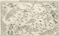
Nordlingen mit der Gegend
Mollova mapová sbírka Bodenehr, Gabriel Bodenehr, Gabriel
La Battaille de Hoechstedt
1 : 50000 Mollova mapová sbírka Husson, Pieter Husson, Pierre
Unter allen Schlachten dieses Seculi hat die Höchste Stadt die Schlacht bey Höchstädt geschehen den 13. Aug. 1704
Geographica Provinciarum Sveviae Descriptio =
Mollova mapová sbírka Hurter, Johann Christoph Bodenehr, Gabriel
Schlacht bey Neresheim am 11.ten August 1796
1 : 170000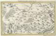
Nordlingen mit der Gegend.
1 : 140000 Mollova mapová sbírka Bodenehr, Gabriel Bodenehr, Gabriel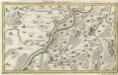
Lauingen und Confinen
1 : 140000 Mollova mapová sbírka Bodenehr, Gabriel Bodenehr, Gabriel
Geographica Provinciarum Sveviae Descriptio =
Mollova mapová sbírka Hurter, Johann Christoph Bodenehr, Johann Georg
172. Nördlingen, uit: Topographische Uebersichtskarte des Deutschen Reiches / herausgegeben v. d. Kartogr. Abt. d. Königl. Preuß. Landesaufnahme
1 : 200000 titelvariant: Topogr. Übersichtskarte des Deutschen Reiches; Annotatie: Titel boven bladen ook: Topogr. Übersichtskarte des Deutschen Reiches; Annotatie geografische gegevens: Op elk blad twee maatstokken: 10 Kilometer = 5,5 cm; 1 geogr. Meile = 3,6 cm; Legenda onder op elk blad Königlich Preußische Landesaufnahme. Kartographische Abtheilung [S.l : Königlich Preußische Landesaufnahme, Kartographische Abtheilung]
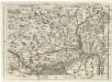
Suevia Universa :
1 : 170000 Mollova mapová sbírka Michal, Jacques de Seutter, Matthäus Seutter, Matthäus
Neueste Karte von der Markgrafschaft Burgau zu den oesterreichischen Vorlanden in Schwaben gehörig
1 Karte : Kupferdruck ; 54 x 47 cm Probst; Sprengler Johann Michael Probst
Theatrum des Krieges in der Marggrafschaft Burgau
Mollova mapová sbírka Stridbeck, Johann Stridbeck, Johann II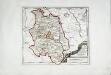
Die Grafschaft Oetingen
1 Karte : Kupferdruck ; 23 x 27 cm Reilly F. J. J. von Reilly
Suevia universa IX. tabulis delineata, 3
1 Blatt : s.n.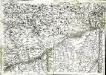
Geographica provinciarum Sueviae descriptio, 4
4 Blätter : Johann Georg Bodenehr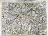
Carte topographique d'Allemagne contenant une partie de Baviere les principautés de Wurtemberg, d'Oettingen
1 Karte : Kupferdruck ; 45 x 63 cm Jaeger se vend chez l'auteur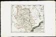
Die Grafschaft Oetingen mit den freyen Reichsstädten Nördlingen Bopfingen und Dünkelsbühl : Nro. 181
Reilly, Franz Johann Joseph von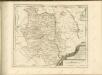

Nieuwe Kaart, van t'Land Donawert, en Hochstett &c.
1 : 200000 Mollova mapová sbírka Visscher, Nicolaes Jansz. Visscher, Nicolaus II.
Mappa geographica comitatvs Oettingensis in circulo Sueviceo siti
1 : 100000 Švábsko (Německo) Cnopf, Matthäus Ferdinand edentibus Homanninanis Heredibus
Pars IV. monstrat mediam partem ducat: Bavariæ, urbem jmp: Augustam Vindelicorum, cum parte ducat Neoburg, et episc. Frising
1 Karte : 54 x 52 cm Heinrich Ludwig Broenner
Mappa Geographica Comitatvs Oettingensis
1 : 100000 Mollova mapová sbírka Cnopf, Matthäus Ferdinand Homann, Johann Baptista - dědici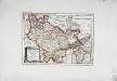
Die freye Reichsstadt Ulm mit ihrem Gebiete
1 Karte : Kupferdruck ; 19 x 27 cm Reilly F. J. J. von Reilly
Ingolstad 129, uit: Special-Karte von Mittel-Europa / nach amtlichen Quellen bearbeitet von W. Liebenow
1 : 300000 titelvariant: W. Liebenow's Mittel-Europa; Annotatie: Titel boven de bladen: W. Liebenow's Mittel-Europa Johannes Wilhelm Liebenow 1822-1897 Frankfurt a. M. : Ludwig Ravenstein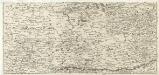
S. R. Imp. Circuli Franconici Geographica Delineatio Francken-Land mit Seinen Gräntzen
Mollova mapová sbírka Endter, Wolfgang Moritz Endter, Wolfgang Moritz
Weitere Fortsetzung des heurigen Kriegs Theatri
Mollova mapová sbírka Lidl, Johann Jakob Lidl, Johann Jacob
Novissima delineatio Marchionatus Burgoviae
1 : 150000 Mollova mapová sbírka Michal, Jacques de Seutter, Matthäus