Maps of Ulm

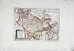
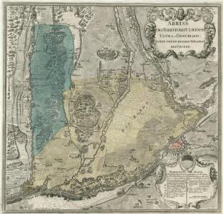
Abriss des Territorii Ulmensis Ultra-Danubialis, Sambt denen Beeden Wildpan. bezürcken
1 : 100000 Mollova mapová sbírka Mayer, Bartholomaeus Bodenehr, Gabriel
Meßtischblatt [7525] : Bermaringen, 1926
1 : 250000 Bermaringen. - 1:25000. - Stuttgart, 1926. - 1 Kt.
Meßtischblatt [7525] : Bermaringen, 1909
1 : 250000 Bermaringen. - 1:25000. - Stuttgart, 1909. - 1 Kt.
Accurater Grund-Riss sambt der Situation und Attaque des H. Röm. Reichs freyen und berühmten Stadt Ulm
Mollova mapová sbírka Bodenehr, Gabriel Bodenehr, Gabriel
Germany [Town plans of], Ulm
Town plans of Germany, GSGS 4480. Great Britain. War Office. [London] : War Office
Meßtischblatt Ulm, 1909
1 : 250000 Ulm. - 1:25000. - Stuttgart, 1909. - 1 Kt.
Ulm mit dero Gegend auf 2 Stund.
1 : 150000 Mollova mapová sbírka Bodenehr, Gabriel Bodenehr, Gabriel
Ulm mit der Gegend auf 1 1/4 Stund
Mollova mapová sbírka Bodenehr, Gabriel Bodenehr, Gabriel
Meßtischblatt [7526] : Langenau, 1926
1 : 250000 Langenau. - 1:25000. - Stuttgart, 1926. - 1 Kt.
Meßtischblatt [7526] : Langenau, 1912
1 : 250000 Langenau. - 1:25000. - Stuttgart, 1912. - 1 Kt.
Meßtischblatt [7425] : Weidenstetten, 1926
1 : 250000 Weidenstetten. - 1:25000. - Stuttgart, 1926. - 1 Kt.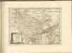
Geographica Provinciarum Sveviae Descriptio =
Mollova mapová sbírka Hurter, Johann Christoph Bodenehr, Gabriel
Nova et accurata Territorii Vlmensis cum Dominio Wainensi Descriptio
1 : 100000 Mollova mapová sbírka Lauterbach, Johann Christoph Homann, Johann Baptista

Nova et accurata territorii Vlmensis cum dominio Wainensi descriptio
1 : 100000 Bádensko-Württembersko (Německo) Lauterbach, Johann Christoph Homann, Johann Baptist Ioh. Baptista Homann
Nova et accurata territorii Vlmensis cum dominio Wainensi descriptio
1 Karte : Kupferdruck ; 47 x 56 cm Lauterbach; Homann Johann Baptist Homann
Nova et accurata territorii Vlmensis cum dominio Wainensi descriptio
1 Karte : Kupferdruck ; 47 x 56 cm Lauterbach; Homann Johann Baptist Homann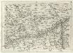
Geographica Provinciarum Sveviae Descriptio =
Mollova mapová sbírka Hurter, Johann Christoph Bodenehr, Johann Georg
Des Herzogthums Würtemberg ostsüdliche Aemter mit der freyen Reichsstadt Giengen
1 Karte : Kupferdruck ; 23 x 26 cm Reilly F. J. J. von Reilly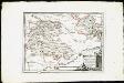
Des Herzogthums Würtemberg ostsüdliche Aemter mit der freyen Reichsstadt Giengen : Nro. 189
Reilly, Franz Johann Joseph von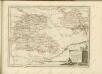

Umgegend von Ulm
1 : 200000 Kartographischen Abtheilung konigl Preuss
179. Ulm, uit: Topographische Uebersichtskarte des Deutschen Reiches / herausgegeben v. d. Kartogr. Abt. d. Königl. Preuß. Landesaufnahme
1 : 200000 titelvariant: Topogr. Übersichtskarte des Deutschen Reiches; Annotatie: Titel boven bladen ook: Topogr. Übersichtskarte des Deutschen Reiches; Annotatie geografische gegevens: Op elk blad twee maatstokken: 10 Kilometer = 5,5 cm; 1 geogr. Meile = 3,6 cm; Legenda onder op elk blad Königlich Preußische Landesaufnahme. Kartographische Abtheilung [S.l : Königlich Preußische Landesaufnahme, Kartographische Abtheilung]
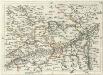
Nieuwe Kaart, van t'Land Donawert, en Hochstett &c.
1 : 200000 Mollova mapová sbírka Visscher, Nicolaes Jansz. Visscher, Nicolaus II.
Meßtischblatt [7524] : Blaubeuren, 1935
1 : 250000 Blaubeuren. - 1:25000. - Stuttgart, 1935. - 1 Kt.
Meßtischblatt [7426] : Dettingen a. Albuch, 1926
1 : 250000 Dettingen a. Albuch. - 1:25000. - Stuttgart, 1926. - 1 Kt.
Meßtischblatt [7624] : Schelklingen, 1912
1 : 250000 Schelklingen. - 1:25000. - Stuttgart, 1912. - 1 Kt.
Meßtischblatt [7424] : Deggingen, 1930
1 : 250000 Deggingen. - Hrsg. 1904, berichtigt 1927. - 1:25000. - Stuttgart, 1930. - 1 Kt.