Maps of Landkreis Lichtenfels

Chur Sächsischer Post-Charten Extract mit allen Chur Sächsischen und vielen daren gräntzenden Post Stationen
1 : 2100000 Mollova mapová sbírka Weigel, Johann Christoph Weigel, Christoph I.
Neue Sächsischen Post-Charte mitt denem Post-Wegen und Strasse, wie viele Meilen die Stationem vom ein ander liegen
1 : 480000 Mollova mapová sbírka Schenk, Pieter Schenk, Peter II
Neue Sächsischen Post-Charte mitt denem Post-Wegen und Strasse, wie viele Meilen die Stationem vom ein ander liegen
1 : 480000 Mollova mapová sbírka Schenk, Pieter Schenk, Peter II
Kriegs-Expeditions-Carte von Bohmen II. Blat, in welcher die Kriegs-Operationen von Prag und Eger vorgestellt werden
1 : 69600 Cheb (Česko) von Homaen[n] Erben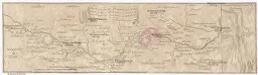
Marsch des k. frantzöischen Corpo, so Duc d'Mallabois com[m]andirt, wie weit selbiges in Böhmen avancirt A. 1742
1 : 247000 Cheb-oblast (Česko)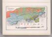
Coal Fields No. 7, Austria. Coal Resources of the World.
1 : 142857 Petrascheck, W.
Karte des Neustraschitzer Bezirkes im Prager Kreise
1 : 72000 Nové Strašecí-oblast (Česko) Wagner, Jan Eduard in Commission bei Karl André
Karte des Neustraschitzer Bezirkes im Prager Kreise
1 : 72000 Nové Strašecí-oblast (Česko) Wagner, Jan Eduard in Commission bei Karl André
Umgebungen von Carlsbad und Eger
Cheb-oblast (Česko) Kiss, Josef K. u. k. Militärgeographisches Institut

Cheb
1 : 75000 Cheb-oblast (Česko) Vojenský zeměpisný ústav
Karlsbad und Luditz
1 : 75000 Karlovy Vary (Česko : oblast) Höller, K. K. u. k. Militärgeographisches Institut
Karlsbad und Luditz
1 : 75000 Karlovy Vary (Česko : oblast) K. u. k. Militärgeographisches Institut
Karte des politischen Bezirkes Falkenau
1 : 30000 Sokolov-oblast (Česko) Hoffmann, Josef Franz Wurda
Podersam und Rakonitz
1 : 75000 Podbořany (Česko : oblast) K. u. k. Militärgeographisches Institut
Podersam und Rakonitz
1 : 75000 Podbořany (Česko : oblast) Hertel, A. K. u. k. militär-geographisches Institut
Podersam und Rakonitz
1 : 75000 Podbořany (Česko : oblast) Hertel, A. K. u. k. Militärgeographisches Institut
Podersam und Rakonitz
1 : 75000 Podbořany (Česko : oblast) K. u. k. Militärgeographisches Institut
III. vojenské mapování 3949
1 : 75000
Eger und Falkenau
1 : 75000 Cheb (Česko : oblast) Höller, K. K. u. k. militär-geographisches Institut
Eger und Falkenau
1 : 75000 Cheb (Česko : oblast) Höller, K. K. u. k. Militärgeographisches Institut
Eger und Falkenau
1 : 75000 Cheb (Česko : oblast) K. u. k. Militärgeographisches Institut
Karte des Gemeindegrenzen

Soubor přehledných map pro plánování a statistiku: 3952 – Kladno

Soubor přehledných map pro plánování a statistiku: 3952 – Kladno
Mapy plánování ČSR

III. vojenské mapování 3951
1 : 75000
Umgebungen von Lubenz
Lubenec-oblast (Česko) Kiss, Josef K. u. k. Militärgeographisches Institut


