Maps of Březová
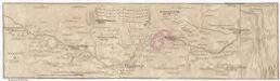
Marsch des k. frantzöischen Corpo, so Duc d'Mallabois com[m]andirt, wie weit selbiges in Böhmen avancirt A. 1742
1 : 247000 Cheb-oblast (Česko)
Eger und Falkenau
1 : 75000 Cheb (Česko : oblast) Höller, K. K. u. k. militär-geographisches Institut
Eger und Falkenau
1 : 75000 Cheb (Česko : oblast) Höller, K. K. u. k. Militärgeographisches Institut
Eger und Falkenau
1 : 75000 Cheb (Česko : oblast) K. u. k. Militärgeographisches Institut
Cheb
1 : 75000 Cheb-oblast (Česko) Vojenský zeměpisný ústav
III. vojenské mapování 3949
1 : 75000
Cheb
1 : 75000 Cheb (Česko : oblast) Vojenský zeměpisný ústav
Accurate geograph. Delineation des zu dem Koenigreich Boehmen gehoerigen Egerischen Creisses
1 : 130000 Cheb-oblast (Česko) Petrus Schenk
Trigonometrisches Netz als Grundlage zur Charte vom Egerlande
1 : 112000 Cheb-oblast (Česko) Kreibich, František Jakub Jindřich David, Martin Alois
Karte des politischen Bezirkes Falkenau
1 : 30000 Sokolov-oblast (Česko) Hoffmann, Josef Franz Wurda
Gradkartenblatt
1 : 25000 Loket-oblast (Sokolov, Česko) Böhm, Karl
Umgebungskarte der Kurstadt Franzensbad
1 : 50000 Cheb (Česko : oblast) E.A. Götz
Umgebungskarte der Kurstadt Franzensbad
1 : 25000 Františkovy Lázně (Česko : oblast) E. A. Götz
Districtvs Egranvs
1 : 217000 Mollova mapová sbírka Müller, Johann Christoph Weigel, Christoph II.
Repraesentatio geographica circvli Egerani nec non Elnbogensis in quo simul viae Egeranae in thermas Carolinas distincta delineato conscriptur
1 : 200000 Cheb-oblast (Česko) Müller, Johann Christoph apud Homannianos Heredes
Repraesentatio Geographica Curculi Egerani nec non Elnbogensis in quo simul viae Egeranae in Thermas Carolinas distincta delineato conscriptur
1 : 200000 Cheb-oblast (Česko) Müller, Johann Christoph apud Homannianos Heredes
[Falkenau und Umgebung]
Sokolov (Česko : oblast)
III. vojenské mapování 3949/1
1 : 25000
Meßtischblatt 5839 : Haslau, 1941
1 : 250000 Haslau. - Aufn. 1908/1920, hrsg. 1923, erkund. 1937/1939,. - 1:25000. - München, 1941. - 1 Kt.
Meßtischblatt Längenau (Schönberg)
1 : 250000 Längenau (Schönberg). - Aufn. 1920, Ausg. 1923, Nachtr. 1936. - 1:25000. - München, 1936. - 1 Kt.
Meßtischblatt 63 (156) : Längenau (Schönberg), 1933
1 : 250000 Längenau. - 1:25000. - München, 1933. - 1 Kt.
Meßtischblatt 1576 : Schönberg, 1929
1 : 250000 Schönberg. - Umdr.-Ausg., aufgen. 1908, hrsg. 1910, bericht. 1922, Nachtr. 1926. - 1:25000. - Leipzig, 1929. - 1 Kt.
Meßtischblatt 156 : Schönberg, 1922
1 : 250000 Schönberg. - Aufgen. 1908, hrsg. 1910, kurrentgest. 1922. - 1:25000. - Leipzig, 1922. - 1 Kt.
Meßtischblatt 156 : Schönberg, 1919
1 : 250000 Schönberg. - Aufgen. 1908, hrsg. 1910, einz. Nachtr. 1919. - 1:25000. - Leipzig, 1919. - 1 Kt.
[Mapový list]
1 : 25000 Lázně Kynžvart-oblast (Česko) Vojenský zeměpisný ústav
Gradkartenblatt
1 : 25000 Cheb-oblast (Česko) Böhm, Karl
III. vojenské mapování 3949/2
1 : 25000
III. vojenské mapování 3949/2
1 : 25000
III. vojenské mapování 3949/1
1 : 25000
![Marsch des k. frantzöischen Corpo, so Duc d'Mallabois com[m]andirt, wie weit selbiges in Böhmen avancirt A. 1742](https://images-2.georeferencer.com/images/iiif/579131893488/full/,300/0/native.jpg)

