Maps of Cheb District
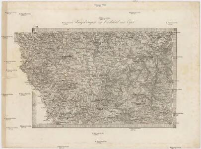
Umgebungen von Carlsbad und Eger
Cheb-oblast (Česko) Kiss, Josef K. u. k. Militärgeographisches Institut
II. vojenské mapování 11
1 : 144000
Geologische Uibersichtskarte vom Ursprunge der Eger bis Karslbad
Karlovy Vary (Česko)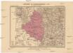
Generalkarte der Bezirkshauptmannschaft Eger
1 : 220000 Cheb-oblast (Česko) Wagner, Jan Eduard F. Kytka
Eger und Falkenau.
from Spezialkarte der osterreichisch-ungarischen Monarchie.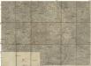
[Umgebung von Eger]
1 : 75000 Cheb (Česko : oblast) K. u. k. Militärgeographisches Institut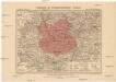
Generalkarte der Bezirkshauptmannschaft Falkenau
1 : 220000 Sokolov-oblast (Česko) Wagner, Jan Eduard F. Kytka
Západočeské lázně

Repraesentatio Geograpica Circuli Egerani nec non Elnbogensis
1 : 80000 Cheb-oblast (Česko) Müller, Johann Christoph Homannios Heredes
Mappa Chorographica Districtus Egrani
1 : 80000 Cheb-oblast (Česko) Müller, Johann Christoph Haberstumpff, Nicolas Christoph Weigel
Districtus Egranus
1 : 80000 Cheb-oblast (Česko) Müller, Johann Christoph Weigel, Christoph Christoph Weigel
Eger und Falkenau
1 : 75000 Cheb (Česko : oblast) Höller, K. K. u. k. militär-geographisches Institut
Eger und Falkenau
1 : 75000 Cheb (Česko : oblast) Höller, K. K. u. k. Militärgeographisches Institut
Eger und Falkenau
1 : 75000 Cheb (Česko : oblast) K. u. k. Militärgeographisches Institut
Cheb
1 : 75000 Cheb (Česko : oblast) Vojenský zeměpisný ústav
Karte vom Egerlande
1 : 57000 Cheb-oblast (Česko) J. Kobrtsch u. Gschihay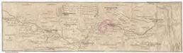
Marsch des k. frantzöischen Corpo, so Duc d'Mallabois com[m]andirt, wie weit selbiges in Böhmen avancirt A. 1742
1 : 247000 Cheb-oblast (Česko)
III. vojenské mapování 3949
1 : 75000
Podrobná mapa Království českého
1 : 100000 Aš (Česko : oblast) Srp, Jan Jos. R. Vilímek
[Vilímkovy místopisné mapy zemí Koruny české]
1 : 100000 Aš (Česko : oblast) Srp, Jan Jos. R. Vilímek
Umgebungskarte der Kurstadt Franzensbad
1 : 75000 Františkovy Lázně (Česko : oblast) E. A. Götz (Windirsch)
Cheb
1 : 75000 Cheb-oblast (Česko) Vojenský zeměpisný ústav
Cheb a okolí
1 : 75000 Cheb (Česko : oblast) Vojenský zeměpisný ústav
Trigonometrisches Netz als Grundlage zur Charte vom Egerlande
1 : 112000 Cheb-oblast (Česko) Kreibich, František Jakub Jindřich David, Martin Alois
Accurate geograph. Delineation des zu dem Koenigreich Boehmen gehoerigen Egerischen Creisses
1 : 130000 Cheb-oblast (Česko) Petrus Schenk
Petrographische Charte des Egrischen Bezirks
1 : 120000 Cheb-oblast (Česko) Müller, Johann Christoph
Karte der Bezirke Eger und Asch
1 : 75000 Aš (Česko : oblast) Stelzig, Heinrich J. Kobrtsch & Gschihay
Charte vom Egerischen Bezirke
1 : 110000 Cheb-oblast (Česko) Kreibich, František Jakub Jindřich David, Martin Alois
Charte vom Egerischen Bezirke
1 : 110000 Cheb-oblast (Česko) Kreibich, František Jakub Jindřich David, Martin Alois