Maps of okres Rakovník

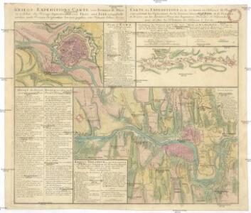
Kriegs-Expeditions-Carte von Bohmen II. Blat, in welcher die Kriegs-Operationen von Prag und Eger vorgestellt werden
1 : 69600 Cheb (Česko) von Homaen[n] Erben
Uebersichtskarte der Buschtěhrader Bahn
Buštěhradská dráha (Česko : zaniklá železniční trať)
Umgebungen von Lubenz
Lubenec-oblast (Česko) Kiss, Josef K. u. k. Militärgeographisches Institut
II. vojenské mapování 13
1 : 144000
Umgebungen von Lubenz
1 : 750000 Lubenec (Česko : oblast) K. k. militär-geographisches Institut
Pragae Metropolis regni Bohemiae
Special - Karte des Koenigreiches Boehmen
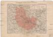
Generální mapa okresního hejtmanství Rakovníckého [sic]
1 : 220000 Rakovník-oblast (Česko) Wagner, Jan Eduard F. Kytka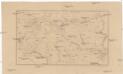
[Kladno a okolí]
Kladno-oblast (Česko)
Rakownický vikariát
Rakovník-oblast (Česko)
Fideicommiss-Domäne Pürglitz
1 : 75000 Křivoklát (Česko : oblast)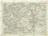
Umgebung von Prag
Praha-oblast (Česko) Biller, Bernhardt Marco Berra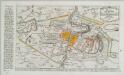
Plan der Battaille welche d. 6. Maj zwischen den Kayserl. Königl. Ungarische[n] u. Königlich Preusische[n] Armee bey Prag geliefert worden. 1757
1 : 90000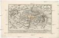
Plan der Battaille welche d. 6. Maj zwischen der kayserlich-königlich-ungarischen und königlich preussischen Armée bey Prag geliefert worden, 1757
Praha (Česko)
Podrobné mapy zemí Koruny české v měřítku 1:75.000 - Smečno - Kladno - Unhošť. Průvodce statisticko-historický po všech místech na těchto mapách uvedených a rejstřík věcný názvů hor, potoků, řek, rybníků atd. a mapa vzdáleností všech míst při silnici ležících Sešit 4. List 41,
1 : 75000
Výškopisný plán hlavního města Prahy s okolím
1 : 20000 Praha (Česko) obec Pražská
Nový, úředně schválený plán Velké Prahy
1 : 25000
Praha a okolí
Praha (Česko : oblast) Kuchař, Karel
Eger und Falkenau
1 : 75000 Cheb (Česko : oblast) Höller, K. K. u. k. militär-geographisches Institut
Eger und Falkenau
1 : 75000 Cheb (Česko : oblast) Höller, K. K. u. k. Militärgeographisches Institut
Eger und Falkenau
1 : 75000 Cheb (Česko : oblast) K. u. k. Militärgeographisches Institut
Uliční mapa hlavního města Prahy
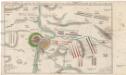
Accurate Vorstellung der zwischen den oesterreichischen und preussischen Armeen geschehenen Bataille bey Prag, den 6. May 1757
Praha (Česko)

Městské podniky Pražské

Plan van de stadt en de beleegering van Praag, 1757 = Plan de la ville & du siege de Prague, en 1757
T. Otten sc. ['s-Gravenhage] : P. Gosse excudit
III. vojenské mapování 3950
1 : 75000

Podersam und Rakonitz
1 : 75000 Podbořany (Česko : oblast) K. u. k. Militärgeographisches Institut
Podersam und Rakonitz
1 : 75000 Podbořany (Česko : oblast) Hertel, A. K. u. k. militär-geographisches Institut
Podersam und Rakonitz
1 : 75000 Podbořany (Česko : oblast) Hertel, A. K. u. k. Militärgeographisches Institut