Maps of Germany

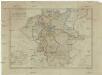
Regni Germaniae delineatio, secundum X. Circulorum divisionem veram suam figuram hodiernos circulorum et regni totius exacte referens
1 : 7900000 Mollova mapová sbírka Franz, Johann Michael Homann, Johann Baptista - dědici
General Karte vom Deutschen Reich
1 Karte : Kupferdruck ; 57 x 63 cm Carmine zu finden bei Joseph Carmine
Karte der fahrbaren oder im Bau begriffenen und der ernstlich projectirten Eisenbahnen in Deutschland, Belgien und Holland, so wie desgleichen einiger in Frankreich, in der Schweiz, in Italien und in Polen
1 : 2470000 Belgie Müller, Emil bey Hoffmann & Campe
Regni Germaniae partium originariarum, ex quibus olim conslatum est facies hodierna ad Circulorum divisionem applicata
1 : 7900000 Mollova mapová sbírka Franz, Johann Michael Homann, Johann Baptista - dědici
Deutschland und anliegende Länder, zur Übersicht der Hauptstrassen und Entfernungen
Hand-Atlas über alle Theile der Erde nach dem neuesten Zustande und über das Weltgebäude Stieler, Adolf bei Justus Perthes
Charte von Deutschland

Germany.
1 : 6000000 Carey, Mathew
Germany.
1 : 6000000 Carey, Mathew
Post Charte von Teutschland
1 : 1750000 Evropa střední Güssefeld, Franz L. Geograph. Institut
[Recto], uit: Post- und Eisenbahn-Karte von Deutschland, den Niederlanden, Belgien und der Schweiz / bearb. nach L. Friedrich's Post-, Eisenbahn- & Reisekarte von Mittel-Europa
1 : 1800000 Annotatie: Ondertitel op omslag: Bis Calais & Paris, Rügen & Königsberg, Krakau & Pesth, Venedig & Grenoble Gotha : Perthes
Deutschland
E. von Sydow's Schul-Atlas in sechs und dreissig Karten Sydow, Emil von bei Justus Perthes
Neueste Generalkarte von Deutschland nach den zehn Kreisen und ihren Unterabtheilungen
1 : 2845000 Evropa střední
Eisen-Bahn-Atlas von Deutschland, Belgien, Elsass und dem nördlichsten Theile von Italien
Stülpnagel, Friedrich von ; Bär, J.C. Justus Perthes
Neu-vermehrte Post-Charte durch gantz Teutschland nach Italien, Franckreich, Niederland, Preußen, Polen, und Ungarn ec
1 : 2470000 Německo Nell, Johann Peter Paar, Carl Joseph von Iohann Baptist Homann
Neu-vermehrte POST-CHARTE durch gantz TEUTSCHLAND nach Italien, Franckreich, Niederland, Preußen, Polen, und Ungarn etc
1 : 2600000 Evropa střední Nell, Johann Peter Homann, Johann Baptist Iohann Baptist Homann
[Neu-vermehrte Post-Charte durch gantz Teutschland nach Italien, Franckreich, Niederland, Preußen, Polen, und Ungarn etc
1 : 2470000 Francie Nell, Johann Peter Homann, Johann Baptist Iohann Baptist Homann
Neu-vermehrte Post-Charte durch gantz Teutschland nach Italien, Franckreich, Niederland, Preußen, Polen, und Ungarn etc
1 : 2470000 Francie Nell, Johann Peter Homann, Johann Baptist Iohann Baptist Homann
Neu-vermehrte Post-Charte durch gantz Teutschland nach Italien, Franckreich, Niederland, Preußen, Polen, und Ungarn etc
1 : 2470000 Francie Nell, Johann Peter Homann, Johann Baptist Iohann Baptist Homann
Neue und vollstaendige Postkarte durch ganz Deutschland und durch die angränzenden Theile der benachbarten Länder
1 : 1465000 Evropa střední Thurn-Taxis, Karel Anselm von denen Homaennischen Erben
Neue und vollstaendige Postkarte durch ganz Deutschland und durch die angränzenden Theile der benachbarten Länder
1 : 1465000 Evropa střední Thurn-Taxis, Karel Anselm von denen Homaennischen Erben
Neue und vollständige Postkarte durch ganz Deutschland und durch die angränzende Theile der benachbarten Länder
1 : 1465000 Evropa střední Heger, Franz Joseph Emmerich Joseph von denen Homaennischen Erben
Charte das Deutsche Reich nach seinen Kreisen und deren Unterabtheilungen vorstellend
1 : 2660000 Francie Güssefeld, Franz L. von den Homännischen Erben
Charte das Deutsche Reich nach seinen Kreisen und deren Unterabtheilungen vorstellend
1 : 2660000 Evropa střední Güssefeld, Franz L. von den Homännischen Erben
Neu vermehrte Post Charte durch gantz Teutschland nach Italien, Franckreich, Niederland, Preußen, Polen, und Ungarn & c
1 : 2600000 Evropa střední Nell, Johann Peter Homann, Johann Baptist Iohann Baptist Homann
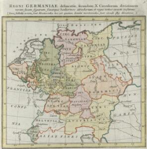
Empire d'Allemagne, divisé en ses dix cercles, ces cercles en leurs principaux estats
1 : 2810000 Evropa střední Sanson, Nicolas Cordier, Louis Pierre Mariette
Deutschland und anliegende Länder, zur Übersicht der Eisenbahnen und Hauptstrassen
Hand-Atlas über alle Theile der Erde nach dem neuesten Zustande und über das Weltgebäude Stieler, Adolf bei Justus Perthes
Neu-vermehrte Post-Charte durch gantz Teutschland nach Italien, Franckreich, Niederland, Preußen, Polen und Ungarn &c.
1 : 2500000 Mollova mapová sbírka Nell, Johann Peter Homann, Johann Baptista
Karte von Central-Europa bis Paris, Mailand, Triest, Pesth, Krakau, Köningsberg, Schleswig, zur Uebersicht der politischen Gestaltung im J. 1867, und der Eisenbahnen und andern Communicationen
1 : 1800000 Annotatie: Bijlage bij: Petermann's geographische Mittheilungen. Ergänzungsheft 19 Gotha : Justus Perthes
Deutschland nach den letzten Friedenschlüssen
1 : 3600000 Evropa střední Mollo, Tranquillo bey Tranquillo Mollo