Maps of Germany

Neueste Generalkarte von Deutschland nach den zehn Kreisen und ihren Unterabtheilungen
1 : 2845000 Evropa střední
Neu vermehrte Post Charte durch gantz Teutschland nach Italien, Franckreich, Niederland, Preußen, Polen, und Ungarn & c
1 : 2600000 Evropa střední Nell, Johann Peter Homann, Johann Baptist Iohann Baptist Homann
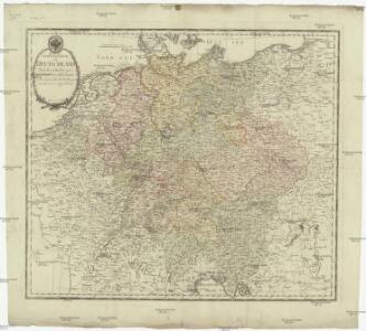
Charte das Deutsche Reich nach seinen Kreisen und deren Unterabtheilungen vorstellend
1 : 2660000 Francie Güssefeld, Franz L. von den Homännischen Erben
Charte das Deutsche Reich nach seinen Kreisen und deren Unterabtheilungen vorstellend
1 : 2660000 Evropa střední Güssefeld, Franz L. von den Homännischen Erben
Imperium Romano-Germanicum in suos circulos electorat. et status
1 : 5100000 Evropa střední Seutter, Matthäus Lotter, Tobias Conrad apud Matth. Seutter
Germany.
1 : 6000000 Carey, Mathew
Germany.
1 : 6000000 Carey, Mathew
Karte von Teutschland
Německo Ritter, C.
Neue und vollstaendige Postkarte durch ganz Deutschland und durch die angränzenden Theile der benachbarten Länder
1 : 1465000 Evropa střední Thurn-Taxis, Karel Anselm von denen Homaennischen Erben
Neue und vollstaendige Postkarte durch ganz Deutschland und durch die angränzenden Theile der benachbarten Länder
1 : 1465000 Evropa střední Thurn-Taxis, Karel Anselm von denen Homaennischen Erben
Neue und vollständige Postkarte durch ganz Deutschland und durch die angränzende Theile der benachbarten Länder
1 : 1465000 Evropa střední Heger, Franz Joseph Emmerich Joseph von denen Homaennischen Erben
General Charte von Teutschland mit Angabe aller Post-Strassen von Paris bis Warschau, und von Triest bis Stralsund
1 : 1760000 Evropa střední Güssefeld, Franz L. Geograph. Institut
Historia Imperii Romano-Germanici, nec non finitimarum Regionum In Mappa exhibita, ac aeri incisa
1 : 2500000 Mollova mapová sbírka Seutter, Matthäus Seutter, Matthäus
Deutschland und anliegende Länder zur Übersicht, d Hauptstr. u. Entfernungen zw. Paris, Mailand, Warschau u. Königsberg
1 : 3800000 Evropa střední Stieler, Adolf Justus Perthes
Eisen-Bahn-Atlas von Deutschland, Belgien, Elsass und dem nördlichsten Theile von Italien
Stülpnagel, Friedrich von ; Bär, J.C. Justus Perthes
Post und Reise Karte von Deutschland und den benachbarten Ländern
Evropa střední Schmitfeldt, Georg Mollo, Eduard bey Eduard Mollo
Societas Iesu Germana Sive Assistentia Germaniae
1 : 2600000 Mollova mapová sbírka Seutter, Matthäus Seutter, Georg Matthäus Seutter, Matthäus
Eisenbahnen in Deutschland und dessen Grenzlaendern
1 : 6200000 Evropa střední Radefeld Zipter, J. geographischen Anstalt des Bibliographischen Instituts
Germaniae Veteris, typus. [Karte], in: Theatrum orbis terrarum, S. 473.
1 Karte aus Atlas Ortelius, Abraham Vrients, Jan Baptista
Carte exacte des postes et routes de l'Empire d'Allemagne divisee en ses cercles.
1 : 2500000 Covens et Mortier
Post Karte durch ganz Deutschland, nach den allerneusten Nachrichten entworfen
1 : 2250000 In Augsburg : zu haben bei Joh. Walch
GERMANIAE | VETERIS | typus.
[Amsterdam : Joan Blaeu]
Charte von Deutschland

Deutschland von 1495 bis 1618.
1 : 3800000 Spruner von Merz, Karl
Germaniae nova et accurata delineatio [Karte], in: Novus atlas absolutissimus, Bd. 2, S. 13.
1 Karte aus Atlas Janssonius Offizin
Germany.
1 : 5200000 Darton, William
Neue und vollstaendige Post-Carte durch ganz Deutschland und die benach barten Lande
1 : 1850000 Evropa střední Güssefeld, Franz L. Heritiers de Chr. Weigel & Schneider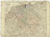
Neue und vollstaendige Post-Carte durch ganz Deutschland und die benach barten Lande
1 : 1850000 Evropa střední Güssefeld, Franz L. Heritiers de Chr. Weigel & Schneider
Neu-vermehrte Post-Charte durch gantz Teutschland nach Italien, Franckreich, Niederland, Preußen, Polen und Ungarn &c.
1 : 2500000 Mollova mapová sbírka Nell, Johann Peter Homann, Johann Baptista