Maps of Germany

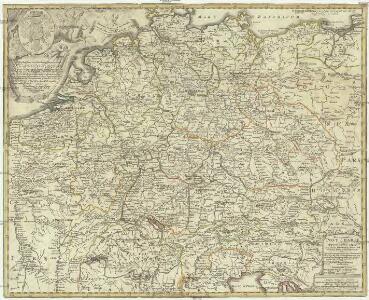
Neu vermehrte Post Charte durch gantz Teutschland nach Italien, Franckreich, Niederland, Preußen, Polen, und Ungarn & c
1 : 2600000 Evropa střední Nell, Johann Peter Homann, Johann Baptist Iohann Baptist Homann
Neueste Generalkarte von Deutschland nach den zehn Kreisen und ihren Unterabtheilungen
1 : 2845000 Evropa střední
Germany.
1 : 6000000 Carey, Mathew
Germany.
1 : 6000000 Carey, Mathew
Historia Imperii Romano-Germanici, nec non finitimarum Regionum In Mappa exhibita, ac aeri incisa
1 : 2500000 Mollova mapová sbírka Seutter, Matthäus Seutter, Matthäus
Charte das Deutsche Reich nach seinen Kreisen und deren Unterabtheilungen vorstellend
1 : 2660000 Francie Güssefeld, Franz L. von den Homännischen Erben
Charte das Deutsche Reich nach seinen Kreisen und deren Unterabtheilungen vorstellend
1 : 2660000 Evropa střední Güssefeld, Franz L. von den Homännischen Erben
Imperium Romano-Germanicum in suos circulos electorat. et status
1 : 5100000 Evropa střední Seutter, Matthäus Lotter, Tobias Conrad apud Matth. Seutter
Karte von Teutschland
Německo Ritter, C.
Eisen-Bahn-Atlas von Deutschland, Belgien, Elsass und dem nördlichsten Theile von Italien
Stülpnagel, Friedrich von ; Bär, J.C. Justus Perthes
Eisenbahnen in Deutschland und dessen Grenzlaendern
1 : 6200000 Evropa střední Radefeld Zipter, J. geographischen Anstalt des Bibliographischen Instituts
Societas Iesu Germana Sive Assistentia Germaniae
1 : 2600000 Mollova mapová sbírka Seutter, Matthäus Seutter, Georg Matthäus Seutter, Matthäus
Deutschland und anliegende Länder zur Übersicht, d Hauptstr. u. Entfernungen zw. Paris, Mailand, Warschau u. Königsberg
1 : 3800000 Evropa střední Stieler, Adolf Justus Perthes
Post und Reise Karte von Deutschland und den benachbarten Ländern
Evropa střední Schmitfeldt, Georg Mollo, Eduard bey Eduard Mollo
Neue und vollstaendige Postkarte durch ganz Deutschland und durch die angränzenden Theile der benachbarten Länder
1 : 1465000 Evropa střední Thurn-Taxis, Karel Anselm von denen Homaennischen Erben
Neue und vollstaendige Postkarte durch ganz Deutschland und durch die angränzenden Theile der benachbarten Länder
1 : 1465000 Evropa střední Thurn-Taxis, Karel Anselm von denen Homaennischen Erben
Neue und vollständige Postkarte durch ganz Deutschland und durch die angränzende Theile der benachbarten Länder
1 : 1465000 Evropa střední Heger, Franz Joseph Emmerich Joseph von denen Homaennischen Erben
Deutschland's kirchliche Eintheilung bis in das XVIte. Jahrhundert.
1 : 3800000 Spruner von Merz, Karl
Carte exacte des postes et routes de l'Empire d'Allemagne divisee en ses cercles.
1 : 2500000 Covens et Mortier
Karte von Central-Europa bis Paris, Mailand, Triest, Pesth, Krakau, Königsberg, Schleswig
1 : 1800000 Budapešť (Maďarsko) Justus Perthes
Neu-vermehrte Post-Charte durch gantz Teutschland nach Italien, Franckreich, Niederland, Preußen, Polen und Ungarn &c.
1 : 2500000 Mollova mapová sbírka Nell, Johann Peter Homann, Johann Baptista
Germaniae nova et accurata delineatio [Karte], in: Novus atlas absolutissimus, Bd. 2, S. 13.
1 Karte aus Atlas Janssonius Offizin

Composite: Carte Generale des Etats composant La Confederation Germanique.
1 : 2750000 Vivien de St Martin, L.
General Karte vom Deutschen Reich
1 Karte : Kupferdruck ; 57 x 63 cm Carmine zu finden bei Joseph Carmine
Charte von Deutschland

Germaniae Veteris, typus. [Karte], in: Theatrum orbis terrarum, S. 473.
1 Karte aus Atlas Ortelius, Abraham Vrients, Jan Baptista
General Charte von Teutschland mit Angabe aller Post-Strassen von Paris bis Warschau, und von Triest bis Stralsund
1 : 1760000 Evropa střední Güssefeld, Franz L. Geograph. Institut
GERMANIAE | VETERIS | typus.
[Amsterdam : Joan Blaeu]