Maps of Rhineland-Palatinate

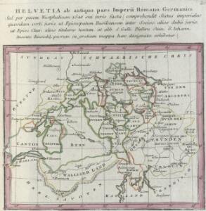
Helvetia ab antiquo pars Imperii Romano-Germanici. Sed per pacem Westphalicam 1648 sui juris facta, comprehendit Status imperiales quosdam certi juris, ut Episcopatum Basileensem inter Socios, alios dubii juris, ut Episc. Chur, alios titulares tantum, ut abb. S. Galli, Pfeffers, Stein, S. Iohann, Disentis, Einsiedel; quorum in gratiam mappa haec designata exhibetur
1 : 2200000 Mollova mapová sbírka Franz, Johann Michael Homann, Johann Baptista - dědici
Bern
1 : 500000 Gotha : Justus Perthes
Le Theatre De La Guerre En Allemagne :
Mollova mapová sbírka Fer, Nicolas de Danet, Guillaume
Smulders' kompas van het westelijk front
1 : 570000 Annotatie: Met informatie over o.a. inwoneraantal en productiegoederen van een aantal landen in de wereld; Annotatie geografische gegevens: De kaart toont de Maginotlinie en de Siegfriedlinie 's-Gravenhage : Smulders
Tabula Nova Particularis Provincie Rheni Superioris [Karte], in: Claudii Ptolemei viri Alexandrini mathematice discipline philosophi doctissimi geographie opus [...], S. 278.
1 Karte aus Atlas Waldseemüller, Martin [und Ptolemaeus, Claudius] Übelin, Georg
Mappa in qua Armisonum Martis Theatrum, ad Rhenum et Mosellam geographico stilo Exacte delineatur
1 : 1200000 Mollova mapová sbírka
Charte des Rhein-Stroms von Breisach bis Linz auch als Post- u. Reise-Charte der umliegenden Länder brauchbar
1 : 617000 Breisach am Rhein (Německo) Streit, Friedrich Wilhelm Joseph Engelmann

Des Ober-Rheinischen Creißes Südlicher theil mit der Franche Comte und den ganzen Hertzogthum Lotharingen
1 : 26000 Mollova mapová sbírka Weigel, Christoph Weigel, Christoph I.
Cursus Rheni a Basilea usque ad Bonnam, III. sectionibus exhibitus
1 : 258000 Basilej (Švýcarsko) Delisle, Guillaume per Homannianos Heredes
Cursus Rheni a Basilea usque ad Bonnam, III. sectionibus exhibitus
1 : 258000 Basilej (Švýcarsko) Delisle, Guillaume per Homannianos Heredes
Carte de France, 4
2 Blätter : Kupferdruck ; 54 x 45 cm Crepy
Piedmont, Monferrat.
1 : 275000 L'Isle, Guillaume de, 1675-1726
Abris Des Rheinstroms
Mollova mapová sbírka
Le cours du Rhin depuis Worms, jusqua Bonne et les pays adjaces / par Guillaume de l'Isle
1 : 220000 Isle, Guillaume de l' [Paris : Ph. Buache]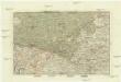
Der Rheinstrohm von Basel bis Maynz
1 : 620000 Basilej (Švýcarsko) Engelman, J.
Germania Prima sive Superior cujus Metropolis Moguntiacum
1 : 875000 Mollova mapová sbírka Sanson, Guillaume Sanson, Guillaume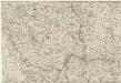
Totius Rheni â fontibus usque ad Ostia Novissima Descriptio
1 : 550000 Mollova mapová sbírka Steudner, Johann P. Bodenehr, Johann Georg Steüdner, Johann Philipp
Pars summa, seu Australis Superioris Rheni Circuli;
1 : 650000 Mollova mapová sbírka Valk, Gerhard Valck, Gerard
Geographica Sueviæ universæ descriptio, 1
1 Blatt : Homännische Erben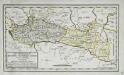
Die Departemente des Ober- und Nieder-Rheins oder das ehemalige Elsass, nebst den angrenzenden Ländern
1 Karte : Typometrie ; 17 x 31 cm Haas; Salzmann bey F. R. Salzmann
Frontiere Franco-Allemande
1 : 320000 Francie

Neue Karte von der Schweiz oder Helvetien in die XIII Eidgenossenschaften, ihre Bundsverwandten und Unterthanen eingetheilt
1 Karte in 2 Bl nach den zuverlässigsten Nachrichten und neuesten astronomischen Beobachtungen, London 1778 bei W. Faden [, neu hrsg. von F.A. Schraembl] Schalbacher, Wien
Karte vom Kriegestheater der vereinigten preussischen und östreichischen Armeen in Frankreich in VI. Blättern, [Blatt 6, 9 und 12]
3 Teile auf 3 Blättern : 72 x 39 cm Königl. preuss. Akademische Kunst- und Buchhandlung
Teatre De La Guerre sur le Rhein, Moessele, Mayn, &c le Necker [Karte], in: Atlas nouveau, contenant toutes les parties du monde [...], Bd. 1, S. 229.
1 Karte aus Atlas Sanson, Nicolas Jaillot, Alexis Hubert und Mortier, Pieter
Composite: Piedmont, Monferrat.
1 : 275000 L'Isle, Guillaume de, 1675-1726
Composite: Piedmont, Monferrat.
1 : 275000 L'Isle, Guillaume de, 1675-1726