Maps of Rheinland-Pfalz

Smulders' kompas van het westelijk front
1 : 570000 Annotatie: Met informatie over o.a. inwoneraantal en productiegoederen van een aantal landen in de wereld; Annotatie geografische gegevens: De kaart toont de Maginotlinie en de Siegfriedlinie 's-Gravenhage : Smulders
Théatre de la guerre, ou carte des frontières de la république française et de l'empire d'Allemagne, 2
1 Teil : Delamarche
Secunda Rheni Et IX. Nova Tabula. [Karte], in: Claud. Ptolemaeus. Geographia lat. cum mappis [...], S. 362.
1 Karte aus Atlas Münster, Sebastian [und Ptolemaeus, Claudius]
[Southwest Germany]
1 : 1400000 [S.l. : s.n.]
Martis Area et Alea per Tractum Rheni, Mosellae, ac Mosae, in qua per plurimos annorum tractus variante eventu saepius certatum, Curatißime designata caelo et studio
1 : 11100000 Mollova mapová sbírka Seutter, Matthäus Seutter, Matthäus
Der Rhein, die Maass und Mosel mit den anliegenden Ländern des Ober-Chur und Nieder-Rhein. wie auch des Burgundischen Kreises ing. Elsass ünd Lothringen &cc
1 : 902000 Alsasko (Francie) Güssefeld, Franz L. bey denen Homaen[n]ischen Erben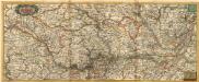
Nova Tractus Totius Rheni T.
1 : 740000 Mollova mapová sbírka Funck, David Funck, David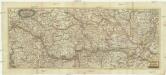
Nova tractus totius Rheni.T
1 : 740000 Evropa západní Funck, David David Funck
Mappa in qua Armisonum Martis Theatrum, ad Rhenum et Mosellam geographico stilo Exacte delineatur
1 : 1200000 Mollova mapová sbírka
Land Charte zum Schau Platz des Kriegs der Röm Kaiserl Maje und dero hohen Alliirten am Rhein
1 : 840000 Mollova mapová sbírka Riegel, Christoph Riegel, Christoph
Landskarte zum Schauplatz des Kriegs der Röm. Kaisers. Maje. und dero hohen alliirten am Rhein
1 : 840000 Německo Christoph Kriegel
Zachodnie granice Niemiec
Deutschland Frankreich Deutsches Reich Grenze Wierzbicki, B.
Accurate Land Charte des Rheins Mossel und Neckar-Stroms
1 : 845700 Mosela, řeka-oblast Christoph Riegel
Le Cercle Eslectorial Du Rhein subdivié entous les Estats qui le composent [Karte], in: Atlas nouveau, contenant toutes les parties du monde [...], Bd. 1, S. 290.
1 Karte aus Atlas Sanson, Nicolas Jaillot, Alexis Hubert und Mortier, Pieter
Der gantze Rhein Strom Von Seinem Ursprung biß zu seinem Ausfluß
1 : 1100000 Mollova mapová sbírka Haupt, Gottfried Jacob Haupt, Gottfried Jacob
Pars summa, seu Australis Superioris Rheni Circuli;
1 : 650000 Mollova mapová sbírka Valk, Gerhard Valck, Gerard
Teatre de la Guerre sur le Rhein, Moessele, Mayn & Necker
1 : 420000 Mollova mapová sbírka Sanson, Guillaume Covens, Johannes I
S. R. I. circulus Rhenanus inferior sive electorum Rheni
1 : 624000 Kolín nad Rýnem (Německo) Homann, Johann Baptist I. B. Homann
S.R.I. circulos Rhenanus inferior sive electorum Rheni
1 : 632000 Kolín nad Rýnem-oblast (Německo) Homann, Johann Baptist â Ioh. Baptista Homanno
Le Cercle Eslectoral du Rhein subdivisé et touts les Estats qui le composent
1 : 560000 Mollova mapová sbírka Sanson, Guillaume Jaillot, Alexis Hubert
Circolo Elettorale del Reno
1 : 730000 Mollova mapová sbírka Mariotti, Vincenzo De Rossi, Giovanni Giacomo
Synopsis Circuli Rhenani Inferioris, Sive Electorum Rheni
1 : 620000 Mollova mapová sbírka Seutter, Matthäus Seutter, Matthäus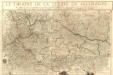
Le Theatre De La Guerre En Allemagne :
Mollova mapová sbírka Fer, Nicolas de Danet, Guillaume
Uterque Rheni Circulus, Superior, et Inferior Electoralis, cum Palatinatu :
1 : 620000 Mollova mapová sbírka Valk, Gerhard Valck, Gerard
S.R.I. circulus Rhenanus inferior sive electorum Rheni
1 : 640000 Dolní Porýní (Německo) Homann, Johann Baptist a Ioh. Baptista Homanno
S.R.I. circulus Rhenanus inferior sive electorum Rheni
1 : 640000 Dolní Porýní (Německo) Homann, Johann Baptist a Ioh. Baptista Homanno
S.R.I. circulus Rhenanus inferior sive electorum Rheni
1 : 640000 Dolní Porýní (Německo) Homann, Johann Baptist a Ioh. Baptista Homanno
S. R. I. circulus Rhenanus inferior sive electorum Rheni
1 : 660000 Kolín nad Rýnem (Německo) Homann, Johann Baptist J.B. Homann
S.R.I. circulus Rhenanus inferior sive electorum Rheni
1 : 640000 Dolní Porýní (Německo) Homann, Johann Baptist á Ioh. Baptista Homanno


