Maps of Piemonte
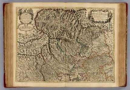
Piedmont, Monferrat.
1 : 275000 L'Isle, Guillaume de, 1675-1726
Composite: Piedmont, Monferrat.
1 : 275000 L'Isle, Guillaume de, 1675-1726
Composite: Piedmont, Monferrat.
1 : 275000 L'Isle, Guillaume de, 1675-1726
[Helvetia antiqua]
1 : 2300000 4 Karten [Johann Ulrich Müller] [Andrea], [Frankfurt a. M.]
Tabula nova eremi Helvetiorum
1 Karte [erstellt von Martin Waldseemüller] [Schott], [Strassburg]
Carte de France, 8
2 Blätter : Kupferdruck ; 53 x 45 cm Crepy
West-Helvetien im 2ten Decennium des XIVten Jahrh
1 : 1300000 1 Karte [bearb. nach Urkunden und den vorzüglichsten Werken Schweizerischer Geschichte von E. Scheuermann] [Scheuermann], [Aarau]
Dr. Konrad Türsts Karte der Eidgenossenschaft 1495/1497
1 : 500000 1 Karte Lith. Anst. J. Tribelhorn, St. Gallen
Neue Karte von der Schweiz oder Helvetien in die XIII Eidgenossenschaften, ihre Bundsverwandten und Unterthanen eingetheilt
1 Karte in 2 Bl nach den zuverlässigsten Nachrichten und neuesten astronomischen Beobachtungen, London 1778 bei W. Faden [, neu hrsg. von F.A. Schraembl] Schalbacher, Wien
Atlas novus Reipublicae Helveticae
1 Atlas ([40] Bl., 97 S.) bey Orell, Gessner und Compagnie, Zürich
[De situ confoederatorum descriptio]
1 : 950000 1 Karte [Konrad Türst] [Verlag nicht ermittelbar], [Erscheinungsort nicht ermittelbar]
Carte de la Suisse
1 : 400000 1 Karte auf 2 Blättern de R. Leuzinger = Karte der Schweiz : Gewässer & Gebirge / von R. Leuzinger Verlag der Dalp'schen Buchhandlung, Bern
[Wallis]
1 : 500000 1 Karte [Johannes Stumpf] [Christoffel Froschouer], [Zürych]
Alsatia Et Brisgoia II. Rheni Et VII. Nova Tabula. [Karte], in: Claud. Ptolemaeus. Geographia lat. cum mappis [...], S. 350.
1 Karte aus Atlas Münster, Sebastian [und Ptolemaeus, Claudius]
Die Departemente des Ober- und Nieder-Rheins oder das ehemalige Elsass, nebst den angrenzenden Ländern
1 Karte : Typometrie ; 17 x 31 cm Haas; Salzmann bey F. R. Salzmann
Landtaflen
1 Atlas [von Johannes Stumpf] Christoffel Froschower, Zürych
Parte occidentale dell'Elvezia divisa ne' suoi cantoni
1 : 600000 1 Karte di nuova projezione / [G. Zuliani inc.] ; [G. Pitteri scri.] presso Antonio Zatta, Venezia
Alsatia Et Brisgoia II. Rheni Et VII. Nova Tabula. [Karte], in: Geographia universalis vetus et nova complectens Claudii Ptolemaei Alexandrini enarrationis libros VIII, S. 317.
1 Karte aus Atlas Münster, Sebastian [und Ptolemaeus, Claudius]
Carte du réseau télégraphique Suisse
1 : 250000 Westblatt Schweizerische Telegraphen- und Telephonverwaltung Kartographische Anstalt LIPS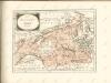

Atlas der Schweiz
1 : 450000 1 Atlas (18 Bl.) gez. u. gest. v. J. Scheurmann Orell Fussli, Zurich
Karte der Schweiz
Švýcarsko Leuzinger, Rudolf J. Dalp
Superioris atque inferioris Alsatiae
1 : 360000 Alsasko (Francie) Lotter, Tobias Conrad Tob. Conr. Lotter
Superioris atque inferioris Alsatiae
1 : 360000 Alsasko (Francie) Lotter, Tobias Conrad Tob. Conr. Lotter
Superioris atque inferioris Alsatiae
1 : 360000 Alsasko (Francie) Lotter, Tobias Conrad Tob. Conr. Lotter
Fragment de l'Atlas de la Suisse par Tschudi 1538
Tschudi, Aegidius Hofer & Burger
Alsatia Landgraviatus
1 : 350000 Mollova mapová sbírka Seutter, Matthäus Seutter, Matthäus
Superioris Atque Inferioris Alsatiae Tabula Perquam Accurata et Exacta
1 : 440000 Mollova mapová sbírka Schenk, Pieter Schenk, Peter II
Landgraviatus Alsatiae tam Superioris quam Inferi.
1 : 350000 Mollova mapová sbírka Homann, Johann Baptist Homann, Johann Baptista