Maps of Vosges

Le cours du Rhin depuis Worms, jusqua Bonne et les pays adjaces / par Guillaume de l'Isle
1 : 220000 Isle, Guillaume de l' [Paris : Ph. Buache]
Teatre De La Guerre sur le Rhein, Moessele, Mayn, &c le Necker [Karte], in: Atlas nouveau, contenant toutes les parties du monde [...], Bd. 1, S. 229.
1 Karte aus Atlas Sanson, Nicolas Jaillot, Alexis Hubert und Mortier, Pieter
Mappa in qua Armisonum Martis Theatrum, ad Rhenum et Mosellam geographico stilo Exacte delineatur
1 : 1200000 Mollova mapová sbírka
Cursus Rheni a Basilea usque ad Bonnam, III. sectionibus exhibitus
1 : 258000 Basilej (Švýcarsko) Delisle, Guillaume per Homannianos Heredes
Cursus Rheni a Basilea usque ad Bonnam, III. sectionibus exhibitus
1 : 258000 Basilej (Švýcarsko) Delisle, Guillaume per Homannianos Heredes
Germania Prima sive Superior cujus Metropolis Moguntiacum
1 : 875000 Mollova mapová sbírka Sanson, Guillaume Sanson, Guillaume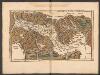
Tabula Nova Particularis Provincie Rheni Superioris [Karte], in: Claudii Ptolemei viri Alexandrini mathematice discipline philosophi doctissimi geographie opus [...], S. 278.
1 Karte aus Atlas Waldseemüller, Martin [und Ptolemaeus, Claudius] Übelin, Georg
Grand Theatre de la Guerre sur les Frontieres de France & d'Allemagne
1 : 240000 Mollova mapová sbírka Delisle, Guillaume Ottens, Josua
Grand theatre de la guerre, frontieres de France, d'Allemagne.
L'Isle, Guillaume de, 1675-1726
Composite: Rhin.
1 : 256000 L'Isle, Guillaume de, 1675-1726
Pars summa, seu Australis Superioris Rheni Circuli;
1 : 650000 Mollova mapová sbírka Valk, Gerhard Valck, Gerard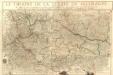
Le Theatre De La Guerre En Allemagne :
Mollova mapová sbírka Fer, Nicolas de Danet, Guillaume
General Idèe Du Terrain qu'ont occupé nos Troupes tant dans la foret noire que le Long de L'inondation et du Rhin. La Campagne. 1735

Abriss des Reinstroms
1 : 870000 Mollova mapová sbírka
Geographica Sueviæ universæ descriptio, 1
1 Blatt : Homännische Erben
Plan des neien Kostranhren Wegs aus Carnte über den Loibl, von Seite miternacht anzusehen
Mollova mapová sbírka Geyer
Veritable repraesentation des fortresses de consequence comme, elles se trouvent actuellement sur Rhein divisées et augmentées pendant la guerre avec plusieurs autres endroits
Německo jihozápadní
Carte des Rein Stroms
Basilej (Švýcarsko)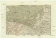
Der Rheinstrohm von Basel bis Maynz
1 : 620000 Basilej (Švýcarsko) Engelman, J.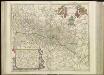
[54][54] Utriusque Alsatiae, Ducatus Dupontii, et Spirensis Episcopatus, uit: Atlas sive Descriptio terrarum orbis
Annotatie: Gedigitaliseerde versie. Amsterdam. Heiloo : Picturae (vervaardiger), 2015. tiff-bestand. Gedigitaliseerd: 07-01-2015; Origineel: Universiteitsbibliotheek Vrije Universiteit (XL.05127.-) ; Netherlands; Titelpagina ontbreekt Wit, Frederik de Amsterdam : Frederick de Wit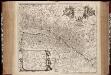
Utriusque Alsatiae, Ducatus Dupontii, et Spirensis Episcopatus novissima descriptio / per F. de Wit
1 : 385000 Annotatie: Origineel is Blad 112 in atlas factice; Annotatie geografische gegevens: Met schaalstokken in: Milliaria Germanica communia, Milliaria Gallica communia, en: Milliaria Magna Italica; West boven [Amsterdam : F. de Wit]
Utriusque ALSATIAE, DUCATUS DUPONTII, et SPIRENSIS EPISCOPATUS Novißima Descriptio
1 : 380000 Alsasko (Francie) Wit, Frederik de F. de Wit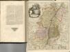
Tertia Rheni Nova Tabula [Karte], in: Claud. Ptolemaeus. Geographia lat. cum mappis [...], S. 365.
1 Karte aus Atlas Münster, Sebastian [und Ptolemaeus, Claudius]
Charte des Rhein-Stroms von Breisach bis Linz auch als Post- u. Reise-Charte der umliegenden Länder brauchbar
1 : 617000 Breisach am Rhein (Německo) Streit, Friedrich Wilhelm Joseph Engelmann
Baden.
1 : 800000 Radefeld, Carl Christian Franz, 1788-1874
Totius Rheni â fontibus usque ad Ostia Novissima Descriptio
1 : 550000 Mollova mapová sbírka Steudner, Johann P. Bodenehr, Johann Georg Steüdner, Johann Philipp
Abris Des Rheinstroms
Mollova mapová sbírka
Tractvs Rhenanvs Svperior
1 : 810000 Mollova mapová sbírka Weigel, Christoph I. - vdova


